
Springpole Gold Project
Springpole Gold Project
Draft Environmental Assessment Report
Document reference number: 96
February 2026
© His Majesty the King in Right of Canada, as represented by the Minister of the Environment, Climate Change and Nature, 2026.
This publication may be reproduced for personal or internal use without permission, provided the source is fully acknowledged. However, multiple copy reproduction of this publication in whole or in part for purposes of redistribution requires the prior written permission from the Impact Assessment Agency of Canada, Ottawa, Ontario K1A 0H3, or information@iaac-aeic.gc.ca.
This document has been issued in French under the title: Projet aurifère Springpole - Version provisoire du rapport d'évaluation environnementale.
Executive Summary
The Impact Assessment Agency of Canada (IAAC) conducted an environmental assessment of the Springpole Gold Project (the project) proposed by First Mining Gold Corp. (the proponent) according to the requirements of the Canadian Environmental Assessment Act, 2012 (CEAA 2012). The project includes the construction, operation, decommissioning, and abandonment of an open-pit gold/silver mine and on-site metal mill, located approximately 110 kilometres northeast of Red Lake, Ontario. As proposed, the project would have an ore production capacity of 65,000 tonnes per day over a 10-year mine life. The on-site metal mill would have an ore input capacity of 30,000 tonnes per day and would operate for 10 years.
On August 28, 2019, the Impact Assessment Act (the IAA) came into force and CEAA 2012 was repealed. However, in accordance with the transitional provisions of the IAA, the environmental assessment of this project is being continued under CEAA 2012 as if it had not been repealed.
The Province of Ontario is conducting an individual environmental assessment under Ontario's Environmental Assessment Act. IAAC and Ontario, represented by the Ontario Ministry of the Environment, Conservation and Parks, coordinated, to the extent possible, the conduct of the federal and provincial assessment processes. This included the acceptance of a single Environmental Impact Statement document written by the proponent to satisfy both the provincial and federal requirements and information sharing during the environmental assessment process. IAAC also sought input from provincial experts in the assessment of effects and considered measures that the Province of Ontario would undertake or ensure to address effects of the project.
In addition to the province, IAAC worked with others to assess the likely effects of the project:
- IAAC consulted and engaged with Indigenous communities throughout the environmental assessment in a manner consistent with Canada's commitment to reconciliation and the principles of free, prior and informed consent. IAAC considered Indigenous Knowledge that was provided to inform the environmental assessment.
- IAAC worked with the proponent, considering information presented in the Environmental Impact Statement and other submissions.
- IAAC considered expert advice from federal authorities, including Environment and Climate Change Canada, Fisheries and Oceans Canada, Health Canada, Indigenous Services Canada (including the First Nations and Indigenous Health Branch), Natural Resources Canada, and Transport Canada.
- IAAC also engaged with the public, inviting comments at various points during the environmental assessment, and considered input received.
This draft Environmental Assessment Report (draft EA Report) provides information about the environmental assessment and sets out IAAC's rationale and conclusions. It also provides a summary of the consultation process conducted with Indigenous Peoples to meet the duty to consult.
IAAC's assessment took into account adverse environmental effects as referred to in section 5 of CEAA 2012, which are focused in areas of federal jurisdiction, including effects related to changes to the environment that are directly linked or necessarily incidental to any federal authorizations required for the project. IAAC considered a range of effect pathways that could result in adverse environmental effects. For example, IAAC considered how changes to "boreal caribou" could be a pathway to an environmental effect on "the current use of lands and resources for traditional purposes by Indigenous Peoples". Where residual adverse environmental effects were predicted to occur after the implementation of mitigation measures, IAAC assessed adverse cumulative effects, that is, effects that are likely to result from the residual effects of the project interacting with effects from other physical activities. IAAC's conclusions regarding whether the project is likely to cause significant adverse environmental effects are summarized in Table i-1.
|
Adverse environmental effect |
IAAC conclusion |
|---|---|
|
Effects on fish and fish habitat |
Residual effects are not likely to be significant. Cumulative effects are not likely to occur. |
|
Effects to migratory birds |
Residual effects and cumulative effects are not likely to be significant. |
|
Effects to the environment on federal lands (Slate Falls Nation Reserve) |
Residual effects are not likely to be significant. Cumulative effects are not likely to occur. |
|
Effects to the health and socio-economic conditions of Indigenous Peoples resulting from any change to the environment |
Residual effects and cumulative effects are not likely to be significant. |
|
Effects to the physical and cultural heritage of Indigenous Peoples and to any structure, site or thing that is of historical, archaeological, paleontological or architectural significance to Indigenous Peoples resulting from any change to the environment |
Residual effects are anticipated. Cumulative effects are not likely to occur. |
|
Effects to the current use of lands and resources for traditional purposes by Indigenous Peoples resulting from any change to the environment |
Residual effects and cumulative effects are not likely to be significant. |
|
Effects related to changes to the environment that are directly linked or necessarily incidental to any federal authorizations required for the project |
Residual effects directly linked or necessarily incidental to federal authorizations required under the Fisheries Act, Metal and Diamond Mining Effluent Regulations, and Canadian Navigable Waters Act are not likely to be significant. Cumulative effects are not likely to occur. |
Once this draft EA Report is finalized, it will be provided to the Minister of the Environment, Climate Change and Nature (the Minister). The Minister will decide whether the project is likely to cause significant adverse environmental effects. If the Minister determines that the project is likely to cause significant adverse environmental effects, then the Minister must refer to Governor in Council the matter of whether those effects are justified in the circumstances.
A comment period is being held on this draft EA Report, along with draft potential conditions. Following the comment period, IAAC will finalize this EA Report to support decision making.
On this page
- Executive Summary
- List of tables
- List of figures
- List of abbreviations and acronyms
- Glossary
- 1 Introduction to the project and environmental assessment process
- 2 Consultation and engagement with Indigenous communities
- 3 Effects to fish and fish habitat
- 4 Effects to migratory birds
- 5 Effects to the environment on federal lands
- 6 Other effects related to federal decisions
- 7 Effects to the health and socio-economic conditions of Indigenous Peoples
- 8 Effects to the physical and cultural heritage and sites of significance of Indigenous Peoples
- 9 Effects to the current use of lands and resources for traditional purposes of Indigenous Peoples
- 10 Collaborative assessments of impacts on Aboriginal and treaty rights
- 11 Impacts on section 35 rights
- 12 Decision making and next steps
- Annexes
List of tables
- Table i-1: IAAC's conclusions on whether the project is likely to cause significant adverse environmental effects
- Table 1-1: Key project components
- Table 3-1: Summary of IAAC's recommended mitigation measures and follow-up program measures pertaining to fish and fish habitat
- Table 4-1: Summary of IAAC's recommended mitigation measures and follow-up program measures pertaining to migratory birds
- Table 6-1: Changes to waterbodies for which a federal decision may be pursued
- Table 7-1: Summary of IAAC's recommended mitigation measures and follow-up program measures pertaining to changes to the health and socio-economic conditions of Indigenous Peoples
- Table 8-1: Summary of IAAC's recommended mitigation measures pertaining to changes to the physical and cultural heritage and sites of significance of Indigenous Peoples
- Table 9-1: Summary of IAAC's recommended mitigation measures and follow-up program measures pertaining to the current use of lands and resources for traditional purposes by Indigenous Peoples
- Table A-1: Malfunction and accident scenarios considered in the assessment
- Table B-1: Analysis of alternative means of carrying out the project
- Table C-1: Definitions and limits used to assign levels of effect for each rating criterion, and likelihood of occurrence
- Table C-2: Description of magnitude ratings
- Table C-3: Decision tree for determining overall significance of a residual effect
List of figures
- Figure 1-1: Project location
- Figure 1-2: Key project component locations
- Figure 4-1: Local and regional study areas for migratory birds
- Figure B-1: Dyke location alternatives
- Figure B-2: Tailings storage location alternatives
List of abbreviations and acronyms
- AAQC
- Provincial Ambient Air Quality Criteria
- CAAQS
- Canadian Ambient Air Quality Standards
- CEAA 2012
- Canadian Environmental Assessment Act, 2012
- CO
- Carbon Monoxide
- COPC
- Contaminants of Potential Concern
- DFO
- Fisheries and Oceans Canada
- EA Report
- Environmental Assessment Report
- EAA
- Environmental Assessment Act
- E1C Transmission Line
- Ear Falls to Pickle Lake Transmission Line
- ECCC
- Environment and Climate Change Canada
- EIS
- Environmental Impact Statement
- IAA
- Impact Assessment Act
- IAAC
- Impact Assessment Agency of Canada
- LSA
- Local Study Area
- MECP
- Ministry of the Environment, Conservation and Parks
- Minister
- Minister of the Environment, Climate Change and Nature
- NO2
- Nitrogen Dioxide
- Ontario
- Government of Ontario
- PDA
- Project Development Area
- Project
- Springpole Gold Project
- Proponent
- First Mining Gold Corp.
- RSA
- Regional Study Area
- SO2
- Sulphur Dioxide
- STPN
- Shared Territory Protocol Nations (Cat Lake First Nation, Lac Seul First Nation, and Slate Falls Nation)
Glossary
The table below defines or explains key terms or phrases that are used in this draft EA Report.
- Abandonment
- The phase of the project after the reflooded basin would be reconnected to Springpole Lake and habitat would be partially restored. Long-term environmental monitoring would continue during abandonment. Referred to as "post-closure" by the proponent.
- Acid rock drainage
- Some rocks, typically those containing an abundance of sulphide minerals, when exposed to water and air, can release water which is more acidic than the natural surrounding environment. Often associated with metal leaching.
- Construction
- The phase of the project during which physical activities would be undertaken that consist of preparing the site and constructing the mine infrastructure, water management systems, co-disposal facility, and dykes, as well as dewatering an area of Springpole Lake. Activities would take place over approximately two to three years.
- Contact water
- Surface water or groundwater that has contacted project components within the mine site.
- Decommissioning
- The phase of the project after production would have permanently ceased, which includes removing infrastructure, revegetating to support habitat restoration, developing a new fish habitat area, flooding the open pit and dewatered area, and lowering the dykes to reconnect to Springpole Lake. Referred to as "active closure" by the proponent and would take approximately five years.
- Effluent
- Contact water that is released from the mine site to the external environment, including controlled, treated effluent and uncontrolled effluent (run-off and seepage that is not contained).
- Ephemeral stream
- A temporary stream that flows for brief periods after rainfall or snowmelt.
- Leased property boundary
- The boundary that represents the proponent's extent of mining claims to be brought to lease.
- Metal leaching
- The release of metals from rocks, site materials and pit walls exposed to water and air, which can increase the concentrations of these metals in contact water. Often associated with acid rock drainage.
- Mine rock
- A natural rock that is extracted during the mining process and does not contain any valuable minerals, such as metals.
- Mine site
- The geographic area overprinted by mining-related components (e.g., dewatered area, open pit, co-disposal facility, stockpiles, processing plant, water management system). Refer also to "project footprint".
- Operations
- The phase of the project during which commercial production takes place and would include open-pit mining, ore processing, mine waste and water management, and progressive reclamation. Activities would take place for approximately ten years.
- Ore
- A natural rock or sediment that contains one or more valuable minerals, such as metals, that can be mined and processed to extract the valuable mineral.
- Overburden
- Material overlying the ore deposit, including rock, soil, and other unconsolidated (i.e., loose) materials.
- Particulate matter (PM10)
- Airborne particles with diameters of 10 micrometres or less.
- Fine particulate matter (PM2.5)
- Airborne particles with diameters of 2.5 micrometres or less.
- Project Development Area
- The geographic study area that includes a 250-metre buffer around the mine site, a 30-metre corridor for the mine access road, and a 40-metre corridor for the transmission line. The shared corridor for the transmission line and mine access road is 60 metres wide.
- Project footprint
- The geographic area overprinted by mining-related project components at the mine site, as well as the transmission line, mine access road, and airstrip. Refer also to "mine site" and "leased property boundary".
- Process water
- Water that is added to the crushed ore during extraction of gold at the processing plant.
- Seepage
- The slow movement of water through soil, rock, or engineered mine structures due to gravity and hydraulic pressure.
- Species at risk
- Any species listed in Schedule 1 of the Species at Risk Act. This includes species recommended for inclusion in Schedule 1 by the Committee on the Status of Endangered Wildlife in Canada (COSEWIC) but does not include species that are listed only under provincial legislation.
- Tailings
- The mixture of ore material, water, and residual chemicals left over after gold is removed from ore in the processing plant.
1 Introduction to the project and environmental assessment process
The Impact Assessment Agency of Canada (IAAC) conducted an environmental assessment (EA) of the Springpole Gold Project (the project) proposed by First Mining Gold Corp. (the proponent) according to the requirements of the Canadian Environmental Assessment Act, 2012 (CEAA 2012). The assessment was coordinated, to the extent possible, with an individual environmental assessment being conducted by the Province of Ontario under its Environmental Assessment Act (EAA).
1.1 Project description
The proponent is proposing the construction, operation, decommissioning, and abandonment of an open-pit gold/silver mine and on-site metal mill, located approximately 110 kilometres northeast of Red Lake, Ontario. As proposed, the project would have an ore production capacity of 65,000 tonnes per day over a 10-year mine life. The on-site metal mill would have an ore input capacity of 30,000 tonnes per day and would operate for 10 years.
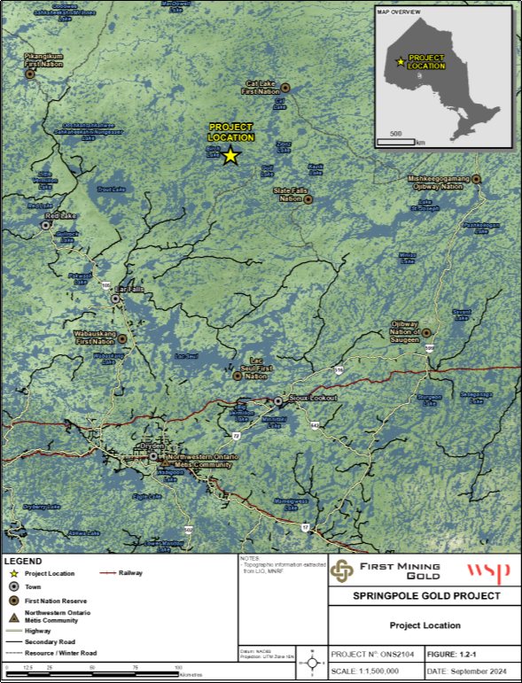
The project is in a remote area in northwestern Ontario (Figure 1-1), situated between Birch Lake and Springpole Lake. The project would also include the construction of an all-season access road, an air strip, and a transmission line.
The purpose of the project is to extract gold and silver to produce semi-pure doré bars that would be transported off-site for further processing and eventual use to meet global demands. The proponent anticipates that the project would provide a return on investment to shareholders, and bring benefits to the local economy and region, including Indigenous communities. This would include increased local and regional revenues and business profits from which future investments in social services, community infrastructure, business development and capacity building would be made.
The project would consist of four main phases:
- Construction (approximately two to three years) would consist of preparing the site and constructing the mine infrastructure, water management systems, co-disposal facility, and dykes, as well as dewatering an area of Springpole Lake.
- Operations (approximately ten years) would include open-pit mining, ore processing, mine waste and water management, and progressive reclamation.
- Decommissioning (approximately five years) would include removing infrastructure, revegetating to support habitat restoration, developing a new fish habitat area, flooding the open pit and dewatered area, and lowering the dykes to reconnect to Springpole Lake.
- Abandonment would begin after the reflooded area is reconnected. Long-term environmental monitoring would continue during abandonment.
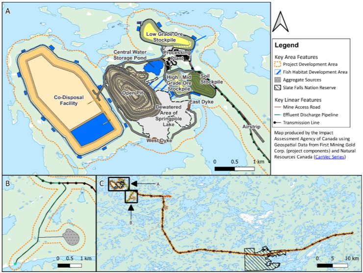
The key project components are depicted in Figure 1-2 and described below in Table 1-1.
Source: Adapted from Springpole Gold Project, Environmental Impact Statement, Figure 1.2-1.
Figure 1-1: Project location - Text version
The Springpole Gold Project would be situated in northwestern Ontario between Birch Lake and Springpole Lake. Nearby Indigenous communities include Cat Lake First Nation, Slate Falls Nation, Mishkeegogamang Ojibway Nation, Wabauskang First Nation, Lac Seul First Nation, and the Northwestern Ontario Metis Community. Nearby towns and municipalities include Red Lake, Ear Falls, Sioux Lookout, and Dryden.
Source: Proponent's geospatial data
Figure 1-2: Key project component locations - Text version
The mine site for the Springpole Gold Project would be situated between Birch Lake and Springpole Lake. A mine access road extends southeast from the mine site and connects to the Wenesaga Forestry Road. The project would receive electricity through a transmission line that runs southeast, parallel to the mine access road, and eventually turns south. Aggregate sources are identified at two locations: one southeast adjacent to the transmission line and one east of the effluent pipeline. The effluent pipeline runs southeast of the mine site and discharges into the southeast arm of Springpole Lake.
|
Component |
Detail |
|---|---|
|
Dewatered Area, Springpole Lake |
Two dykes would be constructed to isolate and dewater a portion of the north basin of Springpole Lake. At decommissioning, the dewatered area would be reflooded, the dykes would be lowered, and the reflooded area would be reconnected with Springpole Lake. |
|
Open Pit |
The open pit would be located within a portion of the dewatered area of Springpole Lake, with an anticipated depth of 321 metres and a surface area of 132 hectares. The pit would be filled with water at decommissioning. |
|
Processing Plant |
Gold and silver would be extracted from crushed ore using various chemical processes including cyanide treatment, solvent washing, and electrowinning. Process water would be recycled in the processing plant. Waste from the process would consist of potentially acid-generating slurry tailings and non-acid generating thickened tailings. Tailings would be treated to remove some of the residual cyanide and transferred to the co-disposal facility via pipeline for storage. |
|
Co-disposal Facility |
The co-disposal facility would be located adjacent to the west side of the open pit. A minimum distance of 120 metres would be maintained from Springpole Lake to the south and from Birch Lake to the north and west. The north cell would store potentially acid-generating mine rock with non-acid generating thickened tailings. The south cell would store potentially acid-generating slurry tailings under an aqueous cover during operations. The facility would have a total surface area of 380 hectares, a final height of approximately 77 metres, and would store 125 million cubic metres of mine waste. The south cell's perimeter embankments would be lined with a low permeability material. The separator berm between the north and south cells would be permeable to allow water to flow to the south cell. The full co-disposal facility would be covered and revegetated at decommissioning. |
|
Ore Stockpiles |
Two ore stockpiles would be located north of the processing plant. A minimum distance of 120 metres would be maintained from Birch Lake. The stockpiles would have footprints of 22 hectares (medium- and high-grade ore) and 26 hectares (low-grade ore) and would range in height from 40 to 60 metres. Non-acid generating mine rock would be used to construct a pad as a buffer between the stockpiles and natural ground. All ore would be processed by the end of operations. A third, smaller stockpile for crushed ore would be maintained next to the processing plant to provide approximately 16 hours of live storage. |
|
Soil Stockpile |
Lakebed sediment and stripped overburden would be stockpiled east of the open pit for reuse in site restoration. The stockpile would have an area of 26 hectares and height of 20 metres. Any remaining soil would be reshaped to a physically stable condition (if needed) and revegetated at the end of decommissioning. |
|
Water Management System and Effluent Treatment |
An integrated site water management system would manage mine water during all phases of the project, until no longer needed at some point during abandonment. Ditches and ponds would intercept contact water (run-off and seepage) and allow settling of coarse suspended solids. The central water storage pond would receive contact water, provide make-up water to the processing plant, and store excess contact water prior to treatment and discharge. The co-disposal facility internal reclaim pond would store contact water from the co-disposal facility cells and perimeter ditching. Water would be pumped to the processing plant for reuse or to the central water storage pond. Excess water from the central water storage pond would be treated at the effluent treatment plant to remove metals, cyanide, and suspended solids before discharge to the southeast arm of Springpole Lake through a 9.3-kilometre effluent discharge pipeline. A packaged sewage treatment plant would treat domestic sewage and grey water. Domestic sewage effluent would be discharged with the mine effluent from the effluent treatment plant. Fresh water would be taken from Birch Lake throughout construction, operation, and decommissioning. A potable water treatment system would treat fresh water intended for drinking purposes. |
|
Transmission Line Corridor |
A 93-kilometre, 230-kilovolt, overhead transmission line would be constructed to connect the project to the provincial electrical distribution grid. It would run parallel to the existing E1C transmission line for 57 kilometres before tying into the Wataynikaneyap 230-kilovolt line between Dinorwic and Pickle Lake. Vegetation would be cleared within a 40-metre corridor around the transmission line. |
|
Mine Access Road |
An all-season access road would be constructed to connect the mine site to the existing regional road network. The two-lane gravel road would extend approximately 17 kilometres from the end of the existing Wenasaga Road to the mine site. |
|
Airstrip |
An airstrip would be located adjacent to the mine access road, approximately two kilometres southeast of the processing plant. It would accommodate a Dash 8 or similar aircraft to support access to the mine site. |
1.2 Environmental assessment process, scope and considerations
IAAC conducted an EA of the project in coordination with the Province of Ontario. The federal EA commenced on April 27, 2018. On that date, IAAC (then called the Canadian Environmental Assessment Agency) issued the Environmental Impact Statement (EIS) Guidelines to the proponent, which described the scope of the assessment and the information and studies required. The proponent prepared an EIS, which was reviewed by IAAC, federal authorities, Indigenous communities, the public, and the Province of Ontario.
On August 28, 2019, the Impact Assessment Act (IAA) came into force and CEAA 2012 was repealed. In accordance with the transitional provisions of the IAA, the EA of this project is being continued under CEAA 2012, as if that Act had not been repealed.
IAAC prepared this draft EA Report which provides information about the EA and sets out IAAC's rationale and conclusions about the project's adverse environmental effects. In preparing this report, IAAC considered multiple sources of information including: the proponent's EIS, Indigenous Knowledge that was provided and other input from Indigenous communities, and comments from the public, federal authorities, and the Province of Ontario.
1.2.1 Assessment scope
IAAC scoped the EA to focus on key adverse environmental effects as referred to in section 5 of CEAA 2012. The adverse environmental effects that are likely to be caused by the project are:
- effects to fish and fish habitat;
- effects to migratory birds;
- effects to the environment on federal lands;
- changes to the environment and the effects of those changes that are directly linked or necessarily incidental to other federal decisions;
- effects of changes to the environment on the:
- health and socio-economic conditions of Indigenous Peoples;
- physical and cultural heritage of Indigenous Peoples, and any structure, site or thing that is of historical, archaeological, paleontological or architectural significance; and
- current use of lands and resources for traditional purposes by Indigenous Peoples.
Environmental effects of the project are described in Sections 3 to 9. Where effects could fall into more than one of the categories listed above, IAAC only assessed them in a single category. For example, effects to migratory birds are not duplicated in the assessments of effects to the environment on federal lands.
In developing its assessment of key adverse environmental effects, IAAC took into consideration comments from Indigenous communities and the public, input from provincial ministries and the proponent, and the advice of federal authorities. Where there were views or perspectives that differed from IAAC's conclusions related to a valued component, the relevant sections below provide additional detail about how those views were considered. In all cases, comments received from stakeholders and Indigenous communities are available upon request from IAAC.
IAAC considered pathways that could lead to adverse environmental effects. For example, IAAC considered how changes to freshwater could be a pathway to an effect to fish and fish habitat. This report focuses on adverse environmental effects and effect pathways that are key issues.
IAAC took into account the proponent's proposed mitigation measures that are technically and economically feasible for each of the adverse environmental effects. At the end of Sections 3, 4, 7, 8 and 9, IAAC identified in a table the recommended mitigation measures that would mitigate any significant adverse environmental effects of the project and follow-up program measures. In addition to adverse environmental effects, IAAC considered the adverse impacts of the project on the exercise of Aboriginal and/or treaty rights (Sections 10 and 11).
1.2.2 Other factors considered in the environmental assessment
In conducting the EA, IAAC considered the factors described in section 19 of CEAA 2012 to the extent of their relevance to the EA. These factors are addressed throughout this EA report. Additional information on some factors is provided below.
Malfunction and accident scenarios
IAAC considered the effects from malfunctions and accidents that may occur in connection with the project in the assessment of adverse environmental effects.
Annex A provides a description of the malfunction and accident scenarios considered. As applicable, adverse environmental effects of malfunctions and accidents are considered in Sections 3 to 9 of this report.
Effects to the project caused by the environment
IAAC considered how effects caused by the environment to the project, such as severe natural events, could be a contributing or complicating factor for malfunctions and accidents. The main consideration was the potential effects of an extreme precipitation event on the site water management system (storage pond, collection ponds and ditches), the co-disposal facility dams, and the dykes in Springpole Lake. To manage the potential effects of an extreme precipitation event on the project, the proponent has designed the ponds and ditches to withstand a 1:100-year storm event, and has designed the co-disposal facility and dykes in accordance with the Canadian Dam Association Safety Guidelines.
Other projects considered in the cumulative effects assessment
IAAC considered how the likely residual adverse environmental effects of the project could interact with effects from other past, present or reasonably foreseeable future physical activities, resulting in cumulative effects. The other physical activities considered were:
- Forestry: The project is located within the Trout Lake Forest Management Unit. As per the 2021 to 2031 Trout Lake Forest Management Plan, areas immediately to the east and southeast of the project may be available for harvest between 2041 and 2061. Some harvest blocks would overlap spatially with proposed project components to the east of the mine site area, portions of the mine access road, effluent pipeline, airstrip, and transmission line.
- Transmission line: The Ear Falls to Pickle Lake (E1C) transmission line is in operation approximately 30 kilometres south of the project and overlaps a portion of the project's proposed transmission line corridor.
As applicable, the cumulative effects of the project in combination with other physical activities are discussed in Sections 3 to 9 of this report.
Alternative means of carrying out the project
IAAC considered the alternative means of carrying out the project identified by the proponent as technically and economically feasible as well as the effects of those means. IAAC also considered the rationale provided by the proponent for its preferred means of carrying out key project elements.
Cat Lake First Nation, Lac Seul First Nation, and Slate Falls Nation expressed concerns regarding their lack of meaningful involvement in the proponent's alternatives assessment, which they noted did not adequately incorporate Indigenous Knowledge, values, or land use priorities. The Nations emphasized that long-term environmental impacts were not sufficiently considered, and that the process appeared to prioritize cost-efficiency over environmental protection. Additionally, concerns were raised about a lack of transparency in how Indigenous input and consultation outcomes were reflected in the assessment.
Based on its review of this analysis, IAAC is satisfied that alternative means have been adequately considered for the purposes of conducting an EA under CEAA 2012. Annex B provides an overview of the alternative means analysis.
Factors not included in the assessment
IAAC determined that the following factors were not relevant to the scope of this EA:
- Paragraph 19(i) of CEAA 2012 requires IAAC to consider the results of any relevant regional studies conducted by a committee established under section 73 or 74 of CEAA 2012; no such studies exist.
- Paragraph 19(j) allows IAAC to identify any other matter related to the EA that it requires to be taken into account; IAAC did not require any other matters to be taken into account.
1.2.3 Criteria for significant adverse environmental effects
Taking into consideration the recommended mitigation measures, and in accordance with IAAC's Operational Policy Statement: Determining Whether a Designated Project is Likely to Cause Significant Adverse Environmental Effects under CEAA 2012, IAAC assessed the likelihood and significance of the residual adverse environmental effects of the project. Where residual adverse environmental effects are predicted to occur, IAAC also assessed the adverse cumulative effects that are likely to result from the project in combination with other physical activities that have been or will be carried out.
IAAC described the residual adverse environmental effects and cumulative effects using the rating criteria defined in Annex C. IAAC drew conclusions on whether those effects are likely to occur and their significance.
1.3 Coordination with other assessment and regulatory processes
In addition to being subject to a federal EA under CEAA 2012, the proponent entered into a voluntary agreement with the Ontario Ministry of the Environment, Conservation and Parks (MECP) to subject the project to the requirements of the Ontario Environmental Assessment Act and is undertaking an individual EA. The proponent conducted environmental studies and engaged with Indigenous communities and the public to address both the federal and provincial requirements. IAAC and the Province of Ontario, represented by MECP, coordinated, to the extent possible, the conduct of the federal and provincial EA processes. This included the acceptance of a single EIS document written by the proponent to satisfy both the provincial and federal requirements and information sharing during the EA process.
1.4 Consultation and engagement with Indigenous communities
IAAC consulted with the following Indigenous communities throughout the EA: Cat Lake First Nation; Lac Seul First Nation; Mishkeegogamang Ojibway Nation; the Northwestern Ontario Métis Community (formerly referred to as the Métis Nation of Ontario, Region 1); Slate Falls Nation; and Wabauskang First Nation. IAAC also engaged with the Ojibway Nation of Saugeen.
Section 2 of this report describes the consultation carried out over the course of the EA process. It also provides information on the Indigenous Knowledge that was provided with respect to the project and was considered by IAAC in conducting the EA and preparing this report. Input from Indigenous communities informed IAAC's assessment and is incorporated throughout the EA Report.
IAAC allocated a total of $712,075.40 in participant funding to support Indigenous communities to understand the effects of the project on community members and their exercise of rights, and to participate in the EA.
Cat Lake First Nation and Lac Seul First Nation conducted the Kita-Ki-Nan "Our Land" process, and Slate Falls Nation conducted an Anishinaabe-led assessment. Where available, a summary of these assessments and their conclusions is included in Section 10, with the full text available on the project page on the Canadian Impact Assessment Registry.
1.5 Public engagement
IAAC engaged the public during the EA through virtual and in-person meetings and formal comment periods on the Summary of the Project Description, the draft EIS Guidelines, and EIS Summary. IAAC also provided updates at key milestones and opportunities to discuss the project with groups who indicated interest, including Grand Council Treaty #3 and the Wildlife Conservation Society Canada.
IAAC provided $14,930.00 in participant funding to help the public participate in the EA.
Written public comments were published on the project page on the Canadian Impact Assessment Registry, subject to privacy, security or confidentiality exceptions. Input from the public informed IAAC's assessment and is incorporated throughout the EA Report, as applicable.
2 Consultation and engagement with Indigenous communities
IAAC is responsible for leading Crown consultation and engagement with Indigenous Peoples for the Government of Canada throughout the EA. Both IAAC and the proponent are expected to maintain bilateral relationships with Indigenous communities throughout EA, with IAAC ensuring that consultation is coordinated, tracked, and responsive to the issues and interests raised. Proponents are expected to undertake early, ongoing, and distinctions-based engagement with Indigenous Peoples to understand and respond to project-specific concerns and to include Indigenous Knowledge in the assessment process.
2.1 IAAC-led consultation and engagement with Indigenous communities
The federal government has a duty to consult Indigenous communities, and, where appropriate, to accommodate, when it has knowledge that its proposed conduct might adversely impact the exercise of Aboriginal and treaty rights recognized and affirmed in section 35 of the Constitution Act, 1982 (section 35 rights). Section 35 of the Constitution Act, 1982, states:
- (1) The existing aboriginal and treaty rights of the aboriginal peoples of Canada are hereby recognized and affirmed;
- (2) In [the Constitution Act, 1982], aboriginal peoples of Canada includes the Indian, Inuit and Métis peoples of Canada;
- (3) For greater certainty, in subsection (1) treaty rights includes rights that now exist by way of land claims agreements or may be so acquired;
- (4) Notwithstanding any other provision of [the Constitution Act, 1982], the aboriginal and treaty rights referred to in subsection (1) are guaranteed equally to male and female persons.
Indigenous consultation is also undertaken more broadly as an important part of good governance, meaningful policy development and informed decision making. The Minister's decision pursuant to subsection 52(1) under CEAA 2012 is considered Crown conduct that could give rise to the common law duty to consult and, where appropriate, accommodate with respect to potential adverse impacts on section 35 rights.
For the purposes of the EA, IAAC served as Crown Consultation Coordinator to facilitate a whole-of-government approach to consultation. These responsibilities are in addition to the requirements under CEAA 2012 to consider the effect of any changes to the environment caused by the project on Indigenous Peoples, the results of which are set out in Sections 7, 8, and 9 of this report. The potential impacts on section 35 rights are discussed in Sections 10 and 11. Indigenous communities with the potential for the project to adversely impact section 35 rights were consulted, as described below.
2.1.1 General overview of consultation
IAAC is committed to advancing reconciliation by working towards implementing the standards set out in the United Nations Declaration on the Rights of Indigenous Peoples (the Declaration). On June 21, 2021, the United Nations Declaration on the Rights of Indigenous Peoples Act received Royal Assent. This Act provides a road map for the government and Indigenous Peoples to work together to fully implement the Declaration. Consultation efforts for the project have been consistent with the Crown's commitment to implement the Declaration by recognizing and upholding the rights of Indigenous Peoples and ensuring there is effective and meaningful participation of Indigenous Peoples throughout the EA in an integrated manner. IAAC also sought to implement the principles outlined in its Reconciliation Framework, namely through maximizing Indigenous leadership in EA, providing limited funding support to Indigenous-led assessments, and including results of these Indigenous-led assessments in the EA to ensure that they factor into the federal government's decision-making process.
IAAC created opportunities throughout the assessment for Indigenous communities to learn about the project, discuss concerns about the project's potential adverse environmental effects and potential impacts on section 35 rights, and discuss possible mitigation and accommodation measures, as appropriate. This information contributed to the Crown's understanding of the project's potential adverse impacts on section 35 rights and the effectiveness of the proposed mitigation measures. IAAC integrated the Crown's consultation and engagement activities throughout the EA process and invited Indigenous communities to review and provide written comments during formal comment periods on the Summary of the Project Description (March 6, 2018 to March 26, 2018), draft EIS Guidelines (April 27, 2018 to May 28, 2018), and EIS Summary (December 2, 2024 to January 10, 2025).
IAAC provided advance notice to Indigenous communities about the process steps following the proponent's submission of the EIS and offered to set up meetings in advance of the comment period to discuss how IAAC could support community capacity for participation. IAAC provided a preliminary analysis of potential impacts to each community for review and validation; input to these summaries was used to inform the draft EA Report. Indigenous communities were notified when IAAC provided Information Requirements (IRs) to the proponent based on Indigenous comments, and IAAC offered to schedule meetings with the proponent and federal authorities to discuss technical issues of concern, if interested. Indigenous communities were also provided an opportunity to review and provide comments on portions of this draft EA Report before the commencement of the public comment period.
IAAC supports Indigenous participation and consultation activities through its Participant Funding Program. Funding was provided to Indigenous communities that participated in the EA process. In total, Indigenous recipients were allocated $712,075.40 in grant and contribution funding.
2.1.2 Shared Territory Protocol Nations – Cat Lake First Nation, Lac Seul First Nation, and Slate Falls Nation
On March 3, 2017, Cat Lake First Nation, Lac Seul First Nation, and Slate Falls Nation signed a Shared Territory Protocol that recognized that the Nations would share certain geographic areas based on traditional use and impact, address and collaborate on all issues related to resource development and land-related activities within those shared territories and cooperate with respect to consultation. Together, these groups were identified as the Shared Territory Protocol Nations (STPN).
IAAC consulted with the STPN to understand potential impacts on community members and their exercise of rights throughout the EA process, beginning in January 2018. IAAC initially reached out individually to each community in support of IAAC's decision as to whether an EA was required. IAAC met jointly with representatives of Cat Lake First Nation and Slate Falls Nation via the Cat–Slate Resource Management Team in mid 2018 to discuss the federal EA process and the draft EIS Guidelines. IAAC met jointly, via the Springpole Environment Committee, with the three STPN member Nations in 2021 to receive comments on the proponent's baseline studies.
On March 30, 2022, the STPN wrote to the proponent to propose that an Anishinaabe-led impact assessment (ALIA) be conducted for the project. Following IAAC's acceptance of the proponent's request for a time limit extension in August 2022, the STPN wrote to IAAC noting disappointment that IAAC did not consult with Indigenous communities before granting a time limit extension to the proponent and requested that IAAC terminate the EA under CEAA 2012 and recommence the assessment under the IAA. On October 13, 2022, IAAC sent a letter to STPN emphasizing its commitment to supporting their ALIA and working collaboratively on next steps. IAAC met with STPN in November 2022 to discuss how it may support their ongoing work and answer their questions about IAAC's experience with Indigenous-led assessments, the differences between CEAA 2012 and the IAA, and how IAAC will consider the Declaration and the STPN member Nations' right to self-government in the federal EA.
In fall 2023, Slate Falls Nation decided to conduct its own independent Anishinaabe-led assessment, while Cat Lake First Nation and Lac Seul First Nation continued to work together to develop and implement the Kita-Ki-Nan "Our Land" process. Continued consultation is detailed separately, as follows.
2.1.3 Cat Lake First Nation and Lac Seul First Nation
Further to the consultation activities described in Section 2.1.2, IAAC continued joint consultation with Cat Lake First Nation and Lac Seul First Nation (in this section, collectively, the Nations). The Nations and IAAC met on February 16, 2024, to discuss potential collaboration and alignment between the Nations' Kita-Ki-Nan assessment process and the federal EA. The Nations provided IAAC with a draft term sheet on May 21, 2024, which outlined a series of proposed terms for a collaboration agreement between the Nations and IAAC. The Nations and IAAC met on July 9, 2024, to discuss these terms in further detail, and IAAC provided a response on August 16, 2024, outlining possible collaboration opportunities under CEAA 2012, and noting interest in continued discussions with the Nations about aligning milestones between the Kita-Ki-Nan process and the federal EA. Throughout the EA process, IAAC endeavoured to schedule meetings with the Kita-Ki-Nan Technical Team to develop a work plan for the collaborative activities of interest identified by the Nations with an interest in aligning key milestones between the federal EA process and Kita-Ki-Nan; however, the Kita-Ki-Nan Technical Team noted significant challenges in aligning the Kita-Ki-Nan process to the legislated timelines for the federal EA process.
Following the submission of the proponent's EIS, IAAC met with the technical team conducting the Kita-Ki-Nan assessment on December 13, 2024, and January 17, 2025, to further discuss potential collaboration opportunities. IAAC received comments from the Nations on the EIS on January 31, 2025, and February 10, 2025. On February 24, 2025, the Kita-Ki-Nan Technical Team confirmed that the Nations would engage with IAAC in a strategic partnership on the development of the IRs and co-drafting of the EA Report.
IAAC and the Kita-Ki-Nan Technical Team met three times in March and April 2025 to discuss IAAC's IRs for the proponent; the Kita-Ki-Nan Technical Team expressed disappointment and frustration at the limited scope of the IRs compared with the Nations' outstanding concerns. IAAC worked to support scheduling of technical meetings throughout June and July 2025 to facilitate resolution of issues of concern to the Nations.
Correspondence from the Nations on September 25, 2024, March 18, 2025, May 13, 2025, and June 17, 2025, expressed discontent with the consultation process, asserting that IAAC had not been sufficiently flexible to adapt its process and take into account the Declaration and the Nations' free, prior, and informed consent in its discussions about a potential collaboration agreement and the development of the IRs.
In May 2025, IAAC provided to the Kita-Ki-Nan Technical Team documents summarizing its preliminary understanding of potential impacts of the project on each of the Nations and their exercise of rights, intended to be a foundation for a discussion of co-drafting on May 14, 2025. The meeting was cancelled by the Kita-Ki-Nan Technical Team, citing disappointment in the scope of the IRs provided to the proponent on May 7, 2025. Correspondence from Lac Seul First Nation on June 28, 2025, and from Cat Lake First Nation on July 4, 2025, provided comments on these preliminary summaries, and was used to develop IAAC's preliminary analysis on potential effects to Indigenous Peoples due to the project.
IAAC provided preliminary portions of this draft EA Report to the Kita-Ki-Nan team on October 23, 2025. The Kita-Ki-Nan team provided feedback to IAAC via correspondence on October 31, 2025, and November 10, 2025, during a meeting on November 21, 2025, and in writing on December 11, 2025. Lac Seul First Nation additionally provided a draft assessment of impacts on their exercise of rights on December 11, 2025, and an updated version on January 7, 2026. Cat Lake First Nation provided a draft assessment of impacts on their exercise of rights on January 19, 2026. IAAC also met with Cat Lake First Nation and Lac Seul First Nation on February 18, 2026, to discuss updated portions of its draft analysis prior to the comment period and receive feedback on key mitigation. These inputs have informed the content of this draft EA Report.
2.1.4 Slate Falls Nation
Further to the consultation activities described in Section 2.1.2, IAAC continued to consult with Slate Falls Nation bilaterally. Slate Falls Nation and IAAC met on March 5, 2024, to discuss potential collaboration and alignment between Slate Falls Nation's ALIA and the federal EA. Over the following months, IAAC and the project coordinator for Slate Falls Nation shared regular phone calls to discuss the development of Slate Falls Nation's studies and ALIA methodology, available funding from IAAC to support Slate Falls Nation's participation in the federal EA, Slate Falls Nation's ongoing discussions with the proponent, and IAAC's consultation workplan.
On May 22, 2024, Slate Falls Nation provided the work plan for the ALIA, and following discussions about potential alignment between the ALIA and the federal EA, IAAC provided its consultation work plan for review and feedback on August 27, 2024. IAAC and Slate Falls Nation's project coordinator met to discuss the plan in September and October 2024. IAAC offered to attend Slate Falls Nation's weekly technical meetings to support better alignment between both processes. IAAC provided the revised consultation plan on September 11, 2024, and again on November 1, 2024, and sent a finalized version on November 28, 2024.
On February 28, 2025, Slate Falls Nation provided a package of comments on the EIS. On March 7, 2025, IAAC received correspondence from Slate Falls Nation's project coordinator noting interest from the Slate Falls Nation team in revisiting the consultation plan. From March to June 2025, IAAC had nearly weekly meetings with the Slate Falls Nation technical team to discuss comments and outstanding technical concerns, Slate Falls Nation's proposed edits on the consultation plan, IAAC's proposed IRs, and the alignment of the ALIA and the federal EA. The Slate Falls Nation technical team provided feedback on IAAC's IRs on May 2, 2025, and proposed edits to the consultation plan on May 26, 2025, and June 3, 2025.
On September 10, 2025, and September 29, 2025, IAAC and Slate Falls Nation met to discuss next steps for co-drafting the EA report. IAAC provided preliminary portions of this draft EA Report to the Slate Falls Nation on October 23, 2025. Slate Falls Nation and IAAC met in person in Toronto on November 4 and 5, 2025, to discuss IAAC's preliminary analysis. Slate Falls Nation shared substantive comments and observations on IAAC's preliminary analysis, which have informed the content of this draft EA Report. Slate Falls Nation provided a draft assessment of impacts on their exercise of rights on December 19, 2025. IAAC also met with Slate Falls Nation on February 10, 2026, to discuss updated portions of its draft analysis prior to the comment period and receive feedback on key mitigation. These inputs have informed the content of this draft EA Report.
2.1.5 Mishkeegogamang Ojibway Nation
IAAC consulted Mishkeegogamang Ojibway Nation to understand potential impacts on community members and on their exercise of rights throughout the EA process, beginning in April 2018. IAAC met with representatives from Mishkeegogamang Ojibway Nation in 2020 and 2023 to discuss key issues of interest to the community and sent correspondence updating the community of developments in the EA. IAAC hosted in-person meetings with Mishkeegogamang Ojibway Nation leadership in Toronto on November 7, 2024, and March 5, 2025, to discuss the EIS and the community's technical concerns. Mishkeegogamang Ojibway Nation noted interest in co-drafting the draft EA Report. IAAC provided a summary of potential impacts to Mishkeegogamang Ojibway Nation on March 13, 2025, for review and comment. On July 29, 2025, IAAC received a letter of support for the project from Chief Merle Loon that confirmed that IAAC could consider their comments on the EIS resolved. IAAC provided preliminary portions of this draft EA Report to Mishkeegogamang Ojibway Nation on October 23, 2025, but did not receive comments prior to the start of the comment period.
2.1.6 Northwestern Ontario Métis Community
IAAC consulted the Northwestern Ontario Métis Community to understand potential impacts on Métis citizens and on their exercise of rights throughout the EA process, beginning in January 2018. IAAC met with representatives from the Northwestern Ontario Métis Community in 2020 and 2023 to discuss key issues of interest to the community, including the scope of IAAC's consultation, and sent correspondence updating the community of developments in the EA. IAAC hosted a meeting on December 5, 2024, with the Northwestern Ontario Métis Community, the proponent, and MECP to discuss the EIS, and received comments from the Métis Nation of Ontario on the EIS on December 20, 2024. On February 20, 2025, and February 21, 2025, IAAC received letters of support for the project from Métis Nation of Ontario President Margaret Froh and Northwestern Ontario Métis Community Regional Councillor Theresa Stenlund, respectively. In a meeting in April 2025, the Métis Nation of Ontario confirmed that IAAC could consider their comments on the EIS resolved. IAAC and the Métis Nation of Ontario agreed to work together to validate IAAC's understanding of impacts to the Northwestern Ontario Métis Community and ensure that the community had opportunities to provide feedback on the EA Report during the public comment period. IAAC provided preliminary portions of this draft EA Report to the Northwestern Ontario Métis Community on October 23, 2025, but did not receive comments prior to the start of the comment period.
2.1.7 Wabauskang First Nation
IAAC consulted Wabauskang First Nation to understand potential impacts on community members and on their exercise of rights throughout the EA process, beginning in January 2018. In October 2023, Wabauskang First Nation expressed interest in remaining updated about future milestones in the EA but noted that they would not be providing comments on the EIS or engaging closely with IAAC and would defer to the more proximate Indigenous communities. IAAC continued to notify Wabauskang First Nation of key milestones through letters and emails, including the submission of the EIS, the start of the public comment period on the EIS, and the publication of its addendum of IRs based on Indigenous community comments. IAAC and representatives from Wabauskang First Nation met on December 2, 2024, to discuss the EIS and agreed that IAAC would share its summary of potential impacts on Wabauskang First Nation for review and validation, and that the community representatives would brief leadership and share any changes to the consultation approach. IAAC followed up to share the summary and to confirm the next steps and did not receive any follow up. IAAC provided preliminary portions of this draft EA Report to Wabauskang First Nation on October 23, 2025, but did not receive comments prior to the start of the comment period.
2.1.8 Ojibway Nation of Saugeen
IAAC did not initially include the Ojibway Nation of Saugeen in consultation activities, as it did not possess any information to identify that the project may adversely impact Ojibway Nation of Saugeen's section 35 rights. In June 2024, Ojibway Nation of Saugeen expressed interest in participating in the federal EA. IAAC met with Ojibway Nation of Saugeen on July 4, 2024, and provided grant funding to support Ojibway Nation of Saugeen's review of the draft EIS to identify potential effects on their community and their exercise of section 35 rights. IAAC continued to notify Ojibway Nation of Saugeen of key milestones through emails, including the submission of the EIS and the start of the public comment period on the EIS. On May 1, 2025, Ojibway Nation of Saugeen provided another letter to IAAC expressing interest in being listed as a community potentially most affected by the project. IAAC met with Ojibway Nation of Saugeen on July 4, 2025, to discuss potential impacts on their community and their exercise of rights, and IAAC provided funding to support their review of the draft EA Report during the public comment period. IAAC received no further information from Ojibway Nation of Saugeen prior to the start of the comment period.
2.2 Proponent-led engagement
The proponent engaged all potentially impacted Indigenous communities identified by IAAC to discuss issues related to the project. Beginning in October 2017, the proponent engaged with the potentially impacted Indigenous communities about their respective practice of section 35 rights, use of lands and resources, and potential effects of the project. The proponent's engagement activities included:
- Regular communication and notification of key project milestones via email, telephone calls, newsletters, and in-person meetings;
- Virtual and in-person community meetings, open houses, and site visits;
- Training and engagement of environmental monitors in field programs;
- Technical review meetings to discuss baseline studies, preliminary alternatives assessment, and issues identified in the EIS; and
- Webinars to discuss the draft EIS, the Fish Habitat Offsetting and Compensation Plan, water management and treatment, and the coordinated assessment process.
In addition, the proponent provided financial support to communities to retain technical experts to review the draft and final EIS, baseline studies, alternatives assessment, and other documents; conduct traditional knowledge, traditional land and resource use, and socio-economic studies, as well as independent Indigenous-led assessments; and hire professional and legal advisors and community support, where appropriate. The proponent has finalized agreements with the Northwestern Ontario Métis Community and Mishkeegogamang Ojibway Nation, who both provided letters of support for the project.
3 Effects to fish and fish habitat
The project is likely to cause residual adverse environmental effects to fish and fish habitat through loss and alteration of fish habitat from dewatering an area of Springpole Lake. With the implementation of the recommended mitigation measures (Table 3-1), IAAC is of the view that the project is not likely to cause significant adverse environmental effects. Cumulative effects are not likely to occur. IAAC has proposed follow-up measures to verify the accuracy of its assessment.
IAAC's assessment of effects to fish and fish habitat focused on key species such as Lake Trout, Walleye, Northern Pike, and Yellow Perch, as well as the aquatic ecosystems that support them. Cat Lake First Nation, Lac Seul First Nation, and Slate Falls Nation emphasized the cultural and subsistence importance of Lake Trout in Springpole Lake, highlighting it as a key resource for year-round harvesting.
IAAC considered effects in the Project Development Area (PDA) (i.e., project footprint plus a 250-metre buffer around the mine site, as well as the mine access road and transmission line corridor); the Local Study Area (LSA) (i.e., the Springpole Lake watershed and Birch Lake, which drains into Springpole Lake); and the Regional Study Area (RSA) (i.e., the Birch Lake watershed, extending downstream to where the Birch River meets Gull Lake, about eight kilometres to the east, past the LSA). Effects were considered for all project phases, from construction through abandonment.
The project may affect Springpole Lake, Birch Lake, 18 small inland waterbodies, and 11 small tributary watercourses. Springpole Lake has a slow-moving north basin and a faster flowing southeast arm, which is fed by the north basin and Birch Lake. Within the north basin, three very deep basins provide critical summer habitat for Lake Trout. Spawning habitat for Lake Trout, Lake Whitefish and Northern Pike is present throughout the north basin and the southeast arm.
Birch Lake supports a diverse fish community, including Lake Trout, Walleye, Northern Pike, and Yellow Perch, due to its complex shoreline and multiple deep basins. The small inland waterbodies provide habitat for small-bodied fish, with some supporting larger species. The small tributary watercourses often have intermittent flows and may occasionally be fish-bearing.
Lake Trout lakes are rare. Only about one percent of Ontario's lakes contain Lake Trout, and this represents 20 to 25 percent of all Lake Trout lakes in the world. Springpole Lake and Birch Lake are designated by Ontario as having naturally reproducing Lake Trout populations and managed accordingly. Lake Trout populations throughout the local fisheries management zone are generally healthy and abundant, with recognition that the species is sensitive to over-exploitation, invasive species, and climate change, and they should be managed with precaution. Ontario has set an objective to maintain the current abundance of Lake Trout in the fisheries management zone.
3.1 Assessment of effects
3.1.1 Loss or alteration of fish habitat
The project is likely to cause the destruction or alteration of approximately 213 hectares of fish habitat. This includes temporary loss and some permanent alteration of fish habitat in Springpole Lake, small inland waterbodies, and small tributary watercourses due to the development of the open pit and other works. It also includes permanent destruction of fish habitat in small inland waterbodies and tributary watercourses due to overprinting by the co-disposal facility and central water storage pond.
Loss of fish habitat in dewatered area of Springpole Lake
Springpole Lake's naturally reproducing Lake Trout population is important for Indigenous communities and contributes to Ontario's fisheries management objectives. This population would be affected by a long-term, partially reversible loss of a deep basin used for summer refuge habitat and a spawning shoal in the dewatered area of Springpole Lake.
Approximately 156 hectares of habitat loss would be partially restored when the dewatered area is reflooded and reconnected to Springpole Lake, after decommissioning and filling of the open pit. Parts of the lakebed would be irreversibly altered by the open pit and unusable by fish species. The deep basin and other habitat would be dewatered for a minimum of 18 years.
Prior to dewatering, fish may be relocated to the remaining areas of Springpole Lake, if licensed to do so by Ontario in accordance with the Fish and Wildlife Conservation Act, 1997. The proponent predicts productivity in Springpole Lake would be reduced during the period of disconnection and would return to pre-disturbance levels within five years of reconnection, and that the Lake Trout population would be sustained during this time.
Harmful alteration, disruption, or destruction of fish habitat is prohibited under the Fisheries Act, except when authorized by Fisheries and Oceans Canada (DFO) and carried out in accordance with established conditions. Authorization for the harmful alteration, disruption or destruction of fish habitat in the dewatered area of Springpole Lake would be conditional on a plan to partially restore the lost habitat and to create or enhance fish habitat elsewhere to offset losses. This includes the predicted reduction in fish productivity during the dewatered period. IAAC recommends that this plan to partially restore the lost habitat in the dewatered area of Springpole Lake and to offset losses be developed and implemented.
Preliminary offsetting concepts include a new fish habitat development area to the east of the reflooded basin. Because there are limited opportunities to restore or create Lake Trout summer refuge habitat in the area, the proponent in consultation with Indigenous communities and DFO, is preparing supplemental offsetting options. Details continue to be refined, but DFO has confirmed there are no technical barriers to the proponent proposing viable and acceptable offsetting solutions for the predicted loss. DFO would require monitoring for the efficacy of restoration in the north basin and offsets.
DFO advised that there is uncertainty about how fish productivity, species composition and population demographics could change in Springpole Lake during the period of disconnection and after reconnection. There are many unpredictable influences on ecosystem dynamics and no known comparable situations. Uncertainty exists as to whether the salvaged fish would be relocated within Springpole Lake or not. DFO advised that it is plausible that the remaining population in Springpole Lake could be sustained, and also plausible that the population could begin to decline unsustainably given the extended period during which the dewatered basin would be inaccessible and the potential that habitat function and use of the basin may not be restored as quickly or effectively as predicted. IAAC recommends that the efficacy of the partial habitat restoration and the new fish habitat development area within Springpole Lake be monitored as part of a follow-up program.
Environment and Climate Change Canada (ECCC) advised that the time required to reconnect the reflooded basin to Springpole Lake may be underestimated. Re-flooding the basin and filling the open pit will require water-taking from Springpole Lake, at rates that are protective of fish and fish habitat in the lake. The proponent predicted that, considering these controlled filling rates, and accounting for time required for the reflooded basin water to meet water quality criteria established through future permitting, reconnection of the reflooded basin to Springpole Lake would occur within five years from the start of filling, resulting in the minimum 18-year period of disconnection.
IAAC recommends that a robust Lake Trout population monitoring program be implemented in Springpole Lake throughout all project phases and for a defined period after the reflooded basin is reconnected. DFO would incorporate this into the conditions of the authorization under the Fisheries Act. The program should define thresholds that would trigger course corrective measures, should monitoring results detect a decline in the Lake Trout population and should the reconnection of the basin be delayed. Following the index netting components and frequency of the provincially standardized broad-scale monitoring protocol could enable comparisons within Ontario's local fisheries management zone. Less lethal monitoring methods should be incorporated at a higher frequency that would be suitable to detect early changes. A nearby comparable lake should be included in the monitoring program and adhere to the same protocol to provide a regional control. The monitoring program should be developed in collaboration with DFO and the Ontario Ministry of Natural Resources (MNR).
The time to reconnection would be largely managed through provincial regulatory frameworks at the time of decommissioning. Water-taking from Springpole Lake (to reflood the dewatered area and fill the open pit) would be managed through Ontario's water-taking framework under the Ontario Water Resources Act. Provincial permitting decisions in this framework would consider ecosystem needs and impacts on water users in Springpole Lake, and can incorporate adaptive management. Ontario would consult with DFO and Indigenous communities, as appropriate. The proponent has also proposed contingency measures in case it is necessary to accelerate the achievement of water quality criteria in the reflooded basin. These include ongoing operation of the effluent treatment plant and in situ water treatment within the reflooded area to facilitate water quality improvement, and would be subject to Ontario's review and approval.
IAAC acknowledges that fish productivity may change in Springpole Lake while important deepwater basin habitat is dewatered and disconnected from the rest of the lake. Partial habitat restoration, offsetting habitat loss and reconnecting as soon as feasible would help support the Lake Trout population, but with some uncertainty. IAAC is of the view that, with the implementation of these mitigation measures, the project is likely to result in residual adverse effects to fish and fish habitat from dewatering an area of Springpole Lake. Specific mitigation and follow-up measures recommended by IAAC are highlighted in the paragraphs above and are included in Table 3-1.
Loss of fish habitat in small inland waterbodies and tributary watercourses
Permanent loss of fish habitat is expected where the co-disposal facility and central water storage pond would overprint small inland waterbodies and tributary watercourses. Schedule 2 of the Metal and Diamond Mining Effluent Regulations under the Fisheries Act would be amended to allow these waterbodies to be used for the disposal of mine waste. Habitat loss would be offset as part of the broader offsetting plan. IAAC recommends that this plan to offset losses be developed and implemented.
Flow reductions from modified drainage patterns are expected in small inland waterbodies and tributary watercourses around the co-disposal facility and stockpiles. Groundwater drawdown would reduce surface flows near the open pit. Some losses would be temporary as groundwater levels and some drainage patterns would be restored after decommissioning. Temporary and permanent fish habitat loss from flow reductions would be offset as a condition of the Fisheries Act authorization. Groundwater drawdown from dewatering the open pit would be managed through Ontario's water-taking framework under the Ontario Water Resources Act, which considers ecosystem needs and impacts on water users. If other water-taking is needed to supplement impacted small inland waterbodies and tributary watercourses, the same framework would apply.
ECCC identified uncertainties in the water quantity modelling for small inland waterbodies east of the stockpiles, which could translate to uncertainties in effects to fish habitat. The proponent will clarify assumptions in its modelling and refine predictions to inform the conditions of the Fisheries Act authorization.
Finally, the mine access road and haul roads within the mine site would require a few water crossings of ephemeral and intermittent streams. If loss of fish habitat cannot be avoided through crossing design, it would also be offset as a condition of the Fisheries Act authorization.
IAAC acknowledges that fish habitat would be lost in small inland waterbodies and tributary watercourses that would be overprinted or modified by project components, and that losses can effectively be offset. IAAC is of the view that, with the implementation of these mitigation measures, the project is not likely to result in residual adverse effects to fish habitat in small inland waterbodies and tributary watercourses from overprinting and flow reductions. Specific mitigation measures recommended by IAAC are included in Table 3-1.
Habitat disturbance from in-water work
In-water construction work could disturb fish habitat in the absence of standard mitigation. In-water construction may be required for water crossings, water intake or discharge structures, and dykes. All construction would follow DFO's Measures to Protect Fish and Fish Habitat and applicable standards and codes of practice. Isolation measures would be installed for the dyke construction in accordance with DFO's Standard: In-Water Site Isolation. Additional measures may be necessary depending on the materials chosen, and would be included as conditions of the Fisheries Act authorization. IAAC is of the view that, with the implementation of these mitigation measures, the project is not likely to result in residual adverse effects to fish habitat from in-water construction works.
Lake sturgeon research program
Indigenous communities have noted that Lake Sturgeon is, or was historically, present in the Birch Lake watershed. DFO's aquatic species at risk map does not identify Lake Sturgeon presence. Proponent surveys did not find evidence of the species in Birch Lake or Springpole Lake, but the proponent acknowledges the potential for remnant populations. As part of the plan to offset loss of fish habitat as required for the Fisheries Act authorization, the proponent has proposed to research the history and recovery potential of Lake Sturgeon in these lakes. This could become a complementary measure for the purposes of the Fisheries Act authorization pending further discussion with DFO.
3.1.2 Fish health and mortality
Changes to water quality can affect fish health. The assessment of effects of the project to fish health focused on controlled effluent that would be discharged to the southeast arm of Springpole Lake and uncontrolled effluent (e.g., uncontained run-off and seepage) that would be released to Springpole Lake and Birch Lake, as well as the related mine waste management and site water management strategies.
Mine waste and site water management
Mine waste and ore stockpiles can generate contaminants through metal leaching and acid rock drainage if not properly managed. Under Ontario's Mining Act, the proponent must file a closure plan with Ontario that conforms with standards in the Mine Rehabilitation Code of Ontario, and provide financial assurance for the costs of closure and rehabilitation. Where materials have the potential for metal leaching and acid rock drainage, the code requires that a mine waste management plan be developed to ensure the materials do not adversely affect the environment. A monitoring program must also be put in place to test the performance of any covers.
Portions of the mine rock, ore and tailings produced by the project would have the potential to generate metal leaching and acid rock drainage. As part of the project's mine waste management plan, mine rock and tailings would be managed together in a co-disposal facility designed to mitigate the onset of metal leaching and acid rock drainage. Potentially metal-leaching and acid-generating slurry tailings would be stored in the south cell under an aqueous cover during operations and under a vegetative cover after decommissioning. Potentially metal-leaching and acid-generating mine rock would be co-disposed with non-acid-generating thickened tailings in the north cell. Non-metal leaching and acid-generating mine rock would be used for construction of the co-disposal facility and possibly elsewhere on the site.
The proposed mine waste management plan design is informed by the geochemical characterization of mine materials available to date, including metal leaching and acid rock drainage release rates used as "source terms" in site models. During operations, mine operators would segregate metal-leaching and acid-generating materials from other materials to ensure the co-disposal facility functions as planned and that the wrong materials are not used for construction or cover. The Mine Rehabilitation Code of Ontario requires that all materials to be left on site be sampled and tested in accordance with the Mine Environment Neutral Drainage Program's Prediction Manual for Drainage Chemistry from Sulphidic Geologic Materials. The proponent indicates that the ongoing geochemical characterization program, which is used to inform planning and continued through construction and operations, is following this manual. IAAC recommends that potential metal-leaching and acid-generating materials be properly identified, segregated and stored.
To reduce uncertainty and minimize contaminant generation, Natural Resources Canada recommended the proponent continually update the source terms used in site models during construction and operation, and amend the mine waste management plan as required. In particular, Natural Resources Canada recommended that the proponent monitor and refine the proposed arsenic cut-off criterion for segregating acid-generating and non-acid generating materials, which includes identifying arsenic-leaching rock that would require storage in the co-disposal facility, and further characterize selenium in the tailings. These refinements should be based on site-specific data, ongoing geochemical testing, and observed water quality trends in any pore water, wells, and water management structures associated with the co-disposal facility, ore stockpiles, and mine rock used for construction. IAAC recommends these ongoing data-driven refinements be undertaken and that they inform the ongoing segregation of materials during construction and operation, as well as updates to the mine waste management plan, in advance of decommissioning, if needed.
The co-disposal facility, ore stockpiles and open pit would result in contact water that would need to be managed before released to the environment. As part of the project's site water management system, ditches and ponds would be positioned to intercept seepage and run-off, and to redirect contact water for re-use within the mine site. Excess contact water would be treated in an effluent treatment plant before final discharge to the environment. IAAC recommends that contact water be managed in this way.
The project cannot collect, treat or discharge mine effluent without an Environmental Compliance Approval for Industrial Sewage Works from Ontario (required under the Ontario Water Resources Act, and issued under the Environmental Protection Act). If issued, this provincial permission would allow the project to operate with environmental controls that protect the natural environment. After consideration of impacts to water, the approval would impose receiver-based effluent criteria and a water management plan, and require necessary monitoring, triggers, and contingency measures.
For the purpose of this EA, the proponent has developed and proposed receiver-based effluent criteria based on Ontario's report B-1-5 Deriving Receiving Water Based Point Source Effluent Requirements for Ontario Waters. They incorporate water quality parameters from the Provincial Water Quality Objectives and Interim Provincial Water Quality Objectives, Canadian Water Quality Guidelines for the Protection of Aquatic Life, and Federal Environmental Quality Guidelines. Final effluent criteria would be approved by Ontario.
IAAC acknowledges the importance of managing mine waste to minimize the generation of contaminants and managing contact water to control effluent discharge. Specific mitigation recommended by IAAC, in relation to mine waste and site water management, are highlighted in the paragraphs above and included in Table 3-1.
Controlled effluent discharge to the southeast arm of Springpole Lake
Treated effluent from the effluent treatment plant would be discharged to the southeast arm of Springpole Lake during operations. This would continue after decommissioning until site runoff is of acceptable quality to discharge directly to the receiving environment. The southeast arm of Springpole Lake was selected over the closer north basin for its higher assimilative capacity. The proponent may relocate the effluent discharge to Birch Lake in response to feedback from Indigenous communities and subject to further analysis and approval by Ontario.
Effluent concentrations within the final effluent discharge and the Springpole Lake southeast arm are predicted to remain within the proponent's proposed receiver-based effluent criteria. Monitoring would be required to demonstrate compliance with the receiver-based criteria established by Ontario as part of an Environmental Compliance Approval for Industrial Sewage Works. Comprehensive monitoring in the receiving environment, and adaptive management, would also be required in the approval.
Effluent at the final discharge point would also be monitored for compliance with the Metal and Diamond Mine Effluent Regulations. These federal regulations set thresholds for the quality of mine effluent that can be discharged into water frequented by fish. The regulations require effluent testing and reporting, as well as Environmental Effects Monitoring studies that assess if effluent quality conditions are sufficiently protective of fish, fish habitat, and use of fish.
Discharge of effluent at the final discharge point could be paused or modified, if needed, in response to the monitoring required for an Environmental Compliance Approval for Industrial Sewage Works or the Metal and Diamond Mine Effluent Regulations.
IAAC acknowledges that treated effluent would be released to the environment in a controlled manner, when necessary, within set limits and with ongoing demonstration that conditions are protective of fish. The mine waste management and site water management strategies would support this. IAAC is of the view that, with the implementation of these mitigation measures, the project is not likely to result in residual adverse effects to fish from controlled effluent discharge in the southeast arm of Springpole Lake.
Uncontrolled effluent in Birch Lake and Springpole Lake
If contact water (run-off and seepage) from project components is not intercepted and contained in the site water management system, it could result in water quality changes in Birch Lake, the north basin of Springpole Lake, and a small inland waterbody that flows into Springpole Lake (Lake 16), which could affect fish health. Run-off is expected to be captured in the site water management system which would be designed with specific stormwater planning considerations in accordance with Ontario's Guide to Applying for an Environmental Compliance Approval. The proponent predicts that not all seepage from the co-disposal facility and the low-grade ore stockpile would be captured in the site water management system.
Seepage from the co-disposal facility would begin in operations and continue through abandonment. The proponent predicted that ten percent of the seepage from the co-disposal facility would bypass the perimeter ditches and ultimately flow into Birch Lake or Springpole Lake. Seepage from the low-grade ore stockpile would occur during operations until the stockpile is exhausted. The proponent predicted that 13 percent of the seepage from the low-grade ore stockpile would flow directly into Birch Lake.
Cat Lake First Nation, Lac Seul First Nation, and Slate Falls Nation raised concerns about the potential for bypass seepage from the co-disposal facility to cause poor water quality and harm fish.
The proponent predicted that contaminant concentrations at the modelled locations in receiving waterbodies would remain within its proposed receiver-based effluent criteria, during all project phases. ECCC noted that the proponent's assessment did not substantiate predicted changes of certain metal concentrations at the seepage face, where seepage has not fully mixed with surface waters, and where effects to fish health are most likely to occur. Contaminants would exist at higher concentrations here prior to being diluted. ECCC therefore noted that acute toxicity to aquatic life may be underestimated and the proponent should demonstrate that certain metals would not cause acute toxicity at the seepage face. IAAC recommends a seepage management follow-up program to demonstrate that concentrations of the metals of concern would not, or do not, cause acute toxicity to fish at the seepage face.
MECP continues to provide guidance to the proponent about how to predict seepage and groundwater flow from the co-disposal facility, and how to mitigate potential seepage-related water quality changes, to support consideration of the necessary permissions under the Environmental Protection Act, such as the Environmental Compliance Approval for Industrial Sewage Works.
The proponent has proposed adaptive management triggers to be incorporated into the Environmental Compliance Approval for Industrial Sewage Works. The proponent would implement a groundwater and surface water quality monitoring program including sampling locations around the co-disposal facility. The proponent would also monitor pore water quality and reclaim pond water quality and optimize internal operations accordingly. The proponent indicated that the co-disposal facility has been designed such that there is enough space to implement pump-back wells, should contingency measures be required to manage seepage. IAAC recommends that the proponent implement contingency measures such as pump-back wells, if needed to prevent acute toxicity to fish.
Since the co-disposal facility would remain in place in perpetuity, following closure and rehabilitation measures, long-term monitoring would also be required under Ontario's Mining Act. The Mine Rehabilitation Code of Ontario under Ontario Regulation 35/24, Rehabilitation of Lands would also require monitoring of surface water and groundwater at decommissioning and abandonment for seepage from on-site sources and discharging from the property boundary, as part of the closure plan. The monitoring would build from the project's baseline studies and water quality monitoring and management program during operations.
IAAC acknowledges that not all seepage would be captured by the site water management system. Since there is uncertainty about the quality of this uncontrolled effluent, the proponent would have to demonstrate it does not cause acute toxicity to fish at the seepage face, and implement contingency measures such as pump-back wells, if needed. Appropriate mine waste management would support this. IAAC is of the view that, with the implementation of these mitigation measures, the project is not likely to result in residual adverse effects to fish health due to uncontrolled effluent at the seepage face in Birch Lake, Springpole Lake and Lake 16. Specific mitigation and follow-up measures recommended by IAAC, in relation to seepage, are highlighted in the paragraphs above and are included in Table 3-1.
Other fish mortality due to project activities
During construction, fish could become trapped in the area that would be isolated and dewatered in Springpole Lake. To avoid the incidental death of fish, a salvage and relocation program would be developed with input from MNR, DFO, and Indigenous communities. IAAC recommends the program be implemented and that Indigenous communities have the option to participate in the relocation and use the fish salvaged, where appropriate. Fish would also be relocated from small inland waterbodies and tributary watercourses prior to overprinting. In addition, all in-water works would be carried out outside of the Ontario Restricted Activity Timing Windows for the Protection of Fish and Fish Habitat to avoid fish death, unless exempt by Ontario to reflect optimal timing associated with fish movement.
Overpressure from blasting in the open pit could affect fish swimming within a 1.4-hectare area of Birch Lake adjacent to the open pit. Safe overpressure thresholds may be exceeded there due to proximity. The proponent would develop a detailed blasting management plan to avoid or minimize the effect, taking into account DFO's Guidelines for the Use of Explosives in or Near Canadian Fisheries Waters and DFO's recommended threshold of 50 kilopascals. Unavoidable effects from blasting would be offset as part of the Fisheries Act authorization for the project.
IAAC is of the view that, with the implementation of mitigation measures, the project is not likely to result in residual adverse effects to fish from salvage and relocation, or blasting. Specific mitigation recommended by IAAC, in relation to fish salvage and relocation, is highlighted above and included in Table 3-1.
3.1.3 Effects from malfunctions and accidents
IAAC considered potential malfunctions and accidents that could harm fish and fish habitat.
A dyke failure, resulting from flooding or erosion, could result in Springpole Lake draining into the open pit, reducing lake water levels and water quality and impacting fish and fish habitat. Under the Lakes and Rivers Improvement Act, Ontario has legislative authority to govern the design, construction, operation, maintenance and safety of dams (including dykes) in Ontario, and would do so through a review and approval of the dykes' locations and plans and specifications. The proponent indicated the dykes would be designed in accordance with the Canadian Dam Association's Dam Safety Guidelines.
A breach of the co-disposal facility dams could result in the release of tailings, pond water, and mine rock into the surrounding environment, with potential migration into Birch Lake or Springpole Lake. Such an event could temporarily affect adjacent land and alter the water quality of the receiving waterbody. IAAC recommends the proponent design, construct and operate the co-disposal facility containment structures in accordance with the Canadian Dam Association's Dam Safety Guidelines. Under Ontario's Mining Act, the closure plan filed in accordance with the Mine Rehabilitation Code of Ontario must detail how the design engineer has given due regard to the Canadian Dam Association's Dam Safety Guidelines and various technical bulletins in the design, construction, maintenance and decommissioning of tailings dams, to ensure their long-term physical stability. The proponent indicated that the co-disposal facility's design and construction would follow safety guidelines and international standards, including the Canadian Dam Association's Dam Safety Guidelines (2013 edition) and 2019 Technical Bulletin on the Application of Dam Safety Guidelines to Mining Dams, and the design requirements of the Global Industry Standard on Tailings Management. The co-disposal facility design was also subject to a technical review by an Independent Geotechnical and Tailings Review Board. The proponent asserted that since the co-disposal facility dams are rockfill founded on bedrock, a catastrophic failure of the dams would be exceedingly unlikely.
Other accidents that could impact fish include the possible malfunction of the water management system during extreme weather which could discharge untreated contact water into Birch Lake and Springpole Lake; the accidental detonation of explosives, which could cause underwater vibration resulting in disturbance or injury to fish; and vehicular accidents or equipment malfunction that could lead to spills of materials that could impact water quality if they were to reach nearby waterbodies, including along the mine access road. The water management system would be designed with specific stormwater planning considerations in accordance with Ontario's Guide to Applying for an Environmental Compliance Approval and would be included in any approval issued under Ontario's Environmental Protection Act. Explosives would be handled and stored in compliance with the Explosives Act, and shipments would follow the requirements of the Transportation of Dangerous Goods Act, 1992.
Specific mitigation measures recommended by IAAC, in relation to malfunctions and accidents, are highlighted in the paragraphs above and included in Table 3-1. In addition, IAAC recommends that an accidents and malfunctions prevention and response plan be developed and implemented, in consultation with Indigenous communities, ECCC, and other relevant authorities, for each phase of the project. While residual adverse effects to fish and fish habitat due to malfunctions and accidents could be possible, IAAC is of the view that such effects have a low probability of occurrence and would be managed by proposed mitigation measures.
3.2 Significance of residual effects
The project is likely to cause residual adverse environmental effects to fish and fish habitat from dewatering an area of Springpole Lake. Residual effects are not likely as a result of habitat loss in small inland waterbodies and watercourse tributaries, in-water works, mine effluent, and other activities.
With the implementation of recommended mitigation measures described in Table 3-1, and based on the rating criteria in Annex C, IAAC concludes that the likely residual effects from dewatering an area of Springpole Lake are moderate in magnitude (measurable effect on fish populations but would not likely result in changes to the regional status of fish populations), limited to Springpole Lake (within the LSA), continuous, and long-term. The likely residual effects are partially reversible, as the reflooded basin would be partially restored and reconnected to Springpole Lake, and as habitat offsetting would be implemented to counterbalance losses. Notwithstanding that construction activities would be conducted outside of sensitive periods, the lost habitat is seasonally important. IAAC acknowledges that there is substantial uncertainty in the time required to reconnect the dewatered area, restore habitat function, and recolonize. IAAC has proposed follow-up and monitoring measures to address this uncertainty.
With the implementation of recommended mitigation measures, IAAC concludes that the project is not likely to cause significant adverse environmental effects to fish and fish habitat. A full list of the mitigation and follow-up measures recommended by IAAC in relation to effects to fish and fish habitat (for habitat in Springpole Lake and for other potential effects to fish), is included in Table 3-1.
3.3 Cumulative effects
The main nearby physical activity is the Trout Lake Forest Management Unit which overlaps with the project in time and space. Under the 2021 to 2031 Trout Lake Forest Management Plan, areas immediately to the east and southeast of the project may be available for harvest between 2041 to 2061. Some harvest blocks would overlap spatially with proposed project components to the east of the mine site area, portions of the mine access road, effluent pipeline, airstrip, and transmission line corridor. Forestry activities could cause localized erosion and sedimentation, but mitigation and rehabilitation measures would be in place to address areas where sediment could reach waterbodies. No residual effects are expected from forest management activities. IAAC is of the view that cumulative effects to fish and fish habitat from the project in combination with other physical activities are not likely. No further mitigation or follow-up measures are recommended.
|
Mitigation measures |
|---|
|
Develop, to the satisfaction of DFO, and implement, a plan to partially restore fish habitat in the reflooded basin after reconnection to Springpole Lake. |
|
Develop, to the satisfaction of DFO and in consultation with Indigenous communities, and implement, a plan to offset the harmful alteration, disruption, or destruction of fish habitat, and death of fish, associated with carrying out the project. For any fish habitat offsetting measure proposed in any offsetting plan that may cause direct or incidental adverse effects, develop and implement measures to mitigate those effects. |
|
Develop, to the satisfaction of Ontario and DFO and implement a protocol to salvage and relocate fish prior to conducting any activity requiring the removal of fish habitat. Consult with Ontario and Indigenous communities prior to relocating fish in Springpole Lake or other waterbodies to identify opportunities for their participation and potential use of the fish. |
|
Manage potential mine effluents in compliance with the pollution prevention provisions of the Fisheries Act and its regulations including the Metal and Diamond Mining Effluent Regulations. |
|
To manage potential mine effluents:
In implementing above measures, ensure to:
|
|
Design, construct and operate the co-disposal facility containment structures in accordance with the Canadian Dam Association's Dam Safety Guidelines. |
|
Develop, prior to construction and in consultation with Indigenous communities and relevant authorities, and implement and maintain, a malfunctions and accidents prevention and response plan for each phase of the project. Include measures to prevent and mitigate effects to fish and fish habitat from, but not limited to, dyke failure, a breach of co-disposal facility dams, malfunction of the water management system, accidental detonation of explosives, and spills. |
|
Follow-up programs |
|
Develop and implement, to the satisfaction of DFO and Ontario, a Lake Trout population monitoring program in Springpole Lake that includes:
|
|
Develop and implement, to the satisfaction of DFO, a follow-up program for the efficacy of fish habitat restoration and development in Springpole Lake, that includes:
|
|
Develop and implement a seepage management follow-up program for the co-disposal facility. As part of this:
|
4 Effects to migratory birds
The project is likely to cause residual adverse environmental effects to migratory birds through displacement due to habitat loss and disturbance from noise and light. With the implementation of the recommended mitigation measures (Table 4-1), IAAC is of the view that the project is not likely to cause significant adverse environmental effects to migratory birds. Cumulative effects that would occur with nearby forestry activities are not likely to be significant. IAAC has proposed a follow-up program to verify the accuracy of its assessment.
IAAC's assessment of effects to migratory birds considered migratory bird displacement, disturbance from noise and light, and risk of mortality due to interactions with the project. It included migratory birds of importance to Indigenous Peoples and species at risk listed under Schedule 1 of the Species at Risk Act (SARA).
IAAC considered effects within the PDA (i.e., project footprint plus a 250-metre buffer around the mine site, as well as the mine access road and transmission line corridor); the LSA (i.e., a two-kilometre buffer around the mine site and mine access road, and a one-kilometre buffer around the transmission line); and the RSA (i.e., a regional area developed by the proponent in consideration of patterns in land cover, watersheds, and eco-districts; Figure 4-1). Effects were considered from construction through abandonment.
Bird habitat in the PDA is mainly composed of coniferous forests (e.g., black spruce, jack pine), deciduous forests (e.g., trembling aspen, white birch), wetlands, and open water areas. Over 100 migratory bird species that are protected by the Migratory Birds Convention Act, 1994 were detected within the RSA, including waterfowl, wetland birds, shorebirds, and forest birds. Of particular note:
- Waterfowl (ducks and geese) of interest to Indigenous Peoples use wetlands and open water throughout the RSA;
- Yellow Rail, a SARA-listed wetland bird of special concern, was detected in the PDA;
- Lesser Yellowlegs, a shorebird, was detected in the PDA. While not listed under SARA, it is assessed as threatened by the Committee on the Status of Endangered Wildlife in Canada;
- Forest bird species at risk detected by the proponent include Canada Warbler, Common Nighthawk, Evening Grosbeak, Olive-sided Flycatcher (in the PDA), Eastern Whip-poor-will (in the LSA), and Eastern Wood-pewee (in the RSA). All are special concern under SARA, except Canada Warbler and Eastern Whip-poor-will which are listed as threatened. Both species have been reassessed as special concern by the Committee on the Status of Endangered Wildlife in Canada in 2020, and 2022, respectively; and
- A Barn Swallow nest was observed in a mine exploration garage in the PDA. Barn Swallow is also listed as threatened under SARA but was reassessed in 2021 as special concern by the Committee on the Status of Endangered Wildlife in Canada.
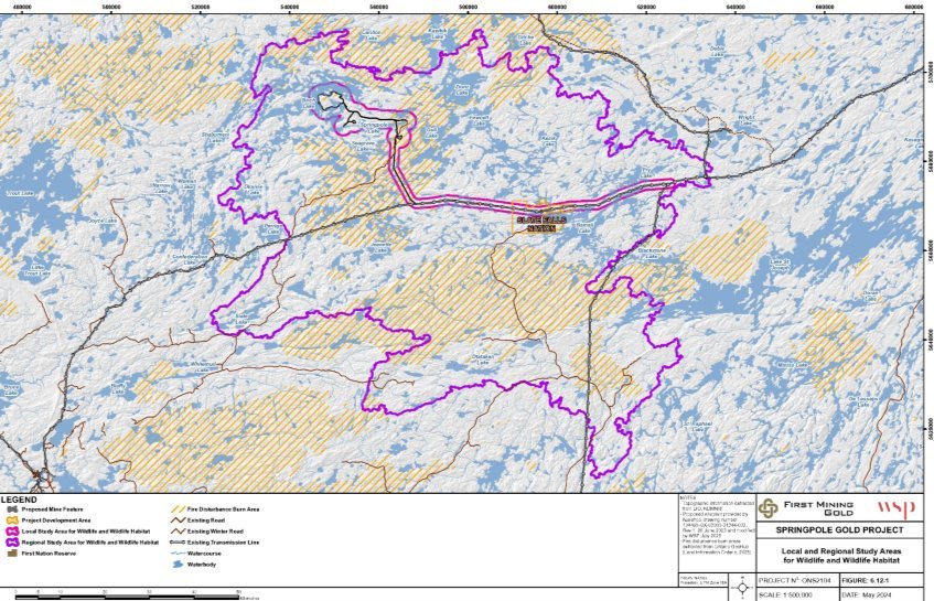
Source: Springpole Gold Project, Environmental Impact Statement, Figure 6.12-1.
Figure 4-1: Local and regional study areas for migratory birds - Text version
A map that delineates the project development area and the local study area and regional study area for migratory birds.
4.1 Assessment of effects
4.1.1 Displacement of migratory birds
Migratory bird habitat would be lost, and migratory birds would be displaced, due to vegetation clearing within the PDA. A high proportion of the PDA is considered suitable habitat for waterfowl and shorebirds that rely on treed areas adjacent to waterbodies, as well as for certain forest bird species that breed in upland forest habitats. In contrast, a relatively low proportion of the PDA provides suitable habitat for wetland-associated bird species. All of these habitat types are regionally abundant. Habitat loss within the PDA represents less than one percent of suitable habitat available within the RSA, for waterfowl, wetland birds, shorebirds, and forest birds, and for each migratory bird species at risk considered. There is no unique habitat within the PDA critical to the survival of migratory birds, including species at risk.
To reduce migratory bird displacement, vegetation clearing would be minimized within the mine access road and transmission line corridors. Progressive revegetation would occur where practicable during operations. Progressive revegetation and final rehabilitation of the mine site would be undertaken in accordance with a closure plan filed with the province to meet the requirements of Ontario's Mining Act. The proponent indicated it would prioritize the use of local vegetation sources and include the creation of wildlife features. IAAC understands this would support the partial rehabilitation of habitat suitable for migratory birds in most areas of the PDA.
IAAC acknowledges that migratory birds would be displaced as a result of vegetation clearing, and that clearing would be kept to a minimum and followed by progressive revegetation. IAAC is of the view that, with the implementation of these measures, the project is likely to result in residual adverse effects to migratory birds due to habitat loss within the PDA. The project would reduce migratory bird abundance in the PDA but would not affect overall regional populations.
4.1.2 Disturbance from noise and light
Increased noise and light may result in disturbance to migratory birds, leading to behavioural change, and local displacement in the LSA.
Noise levels in the PDA and some areas of the LSA would increase during construction, operations, and decommissioning from heavy equipment use and blasting activities. Noise from transmission line construction would be localized and temporary. The proponent would implement buffers around occupied nests in accordance with ECCC's Guidelines to avoid harm to migratory birds. To the extent possible, the proponent would design buildings to shield noise sources, use acoustical enclosures and silencers on equipment, and limit the use of reversing alarms and engine brakes. A monitoring program would be used to verify that project-induced sound levels outside of wildlife protection buffer zones remain below thresholds that are protective of sensitive avian species.
Artificial lighting could deter light-sensitive birds during construction, operations and decommissioning. It could also attract nocturnal species such as the Common Nighthawk and Eastern Whip-poor-will thereby increasing their risk of mortality. The proponent would minimize light spill and glare by using shields on stationary light sources, directional lighting to target areas, optimized lighting design to reduce the amount needed, and smart lighting systems to reduce light use when not required. IAAC recommends that light spill and glare be minimized using these measures.
IAAC acknowledges that noise and light may contribute to behavioural changes and displacement, which can be minimized by following guidelines for sound buffers around nests and carefully managing light. IAAC is of the view that, with the implementation of these measures, the project is likely to result in residual adverse effects to migratory birds due to disturbance from noise and light. Specific mitigation measures recommended by IAAC are included in Table 4-1.
4.1.3 Mortality risk
Vegetation clearing within the PDA during construction could destroy nests containing eggs or juveniles, if undertaken during the breeding season. To mitigate this, vegetation clearing would not be conducted during the sensitive period (late April to late August), as defined in ECCC's Nesting Periods guidance, and would be conducted in accordance with ECCC's Guidelines to avoid harm to migratory birds.
Some migratory bird nests receive year-round protection until they are deemed abandoned (e.g., Pileated Woodpecker and Great Blue Heron). The proponent would determine the presence of protected nests prior to initiating vegetation clearing and, should they be present, the proponent would establish set back distances around the nests while they are protected. Removal of protected nests would have to comply with the Migratory Birds Regulations, 2022.
A Barn Swallow nest that is known to be used and located in a mine exploration garage would have to be removed during the construction phase. Barn Swallow nests are protected as residences under the Species at Risk Act. The nest would be removed outside of the period of occupancy (roughly May to August), in accordance with the Migratory Birds Convention Act, 1994 and the Species at Risk Act.
IAAC recommends all vegetation clearing and nest removal be done in accordance with ECCC's guidance and in a manner that complies with the Migratory Birds Convention Act, 1994 and the Species at Risk Act.
The 93-kilometre transmission line poses a collision risk for waterfowl, grebes, shorebirds, and cranes from construction through decommissioning. ECCC advised this could yield population-level effects if certain populations like shorebirds are already declining. To mitigate collisions, IAAC recommends measures be implemented to increase visibility (e.g., line-marking devices such as aerial marker spheres, spirals, bird strike diverters), taking into consideration the Aviation Power Line Interaction Committee's document Reducing Avian Collisions with Power Lines.
Open water often attracts birds. Some open water within the mine site could have elevated contaminant levels such as the co-disposal facility reclaim pond, central water storage pond, and other contact water ponds. ECCC, Cat Lake First Nation, Lac Seul First Nation, and Slate Falls Nation expressed concerns about waterfowl interacting with these project components. The proponent considered it unlikely as the ponds would not support food for birds during operations. To mitigate potential exposure to contaminants, IAAC recommends the proponent ensure waterfowl do not access stored contact water until it is demonstrated to be protective of birds.
Increased traffic within the PDA during construction, operations and decommissioning would increase the risk of vehicle collisions with migratory birds. Common Nighthawk and Eastern Whip-poor-will are at higher risk because they tend to nest, roost and forage on or around gravel roads. To mitigate vehicle collisions, the proponent would implement speed limits, record any wildlife vehicle collisions, and adapt measures if collisions are being recorded.
IAAC acknowledges the mortality risks caused by vegetation clearing, nest removal, transmission line collisions, contaminated water, and traffic associated with the project. IAAC is of the view that, following the implementation of mitigation measures, the project is not likely to result in residual adverse effects to migratory birds due to new mortality risks. Specific mitigation measures recommended by IAAC are included in Table 4-1.
Cat Lake First Nation and Lac Seul First Nation expressed concern that the proponent's assessment potentially underestimates the residual effects on waterfowl populations. IAAC recommends the proponent develop a follow-up and monitoring program prior to construction, and in consultation with ECCC and Indigenous communities, to verify the accuracy of the assessment and to determine the effectiveness of mitigation measures, related to avoiding harm to waterfowl. This follow-up program recommended by IAAC is included in Table 4-1.
4.1.4 Effects from malfunctions and accidents
Malfunction of the cyanide destruction process within the process plant could cause the co-disposal facility to store tailings and contact water with higher concentrations of cyanide and metals. Should a malfunction occur, the process plant would be shut down until cyanide destruction is restored. Freshwater could also be introduced, as needed, to ensure appropriate pond water quality. As noted above, IAAC recommends the proponent ensure waterfowl do not access stored contact water to mitigate potential exposure to contaminants.
Spills of hazardous materials during transportation and storage, such as liquid cyanide or hydrocarbon materials, could enter the natural environment and increase the risk of mortality to migratory birds. Based on advice from ECCC, IAAC recommends that an accidents and malfunctions prevention and response plan be developed and implemented in relation to each phase of the project, taking into consideration ECCC's Guidelines for Wildlife Response Plans. It should include measures for the protection of migratory birds from spills including, stationing appropriately stocked spill kits, using biodegradable oils (e.g., hydraulic oil) for equipment near water, using secondary containment systems, regularly inspecting the storage and dispensing systems, and applying fuel transfer and dispensing best practices.
4.2 Significance of residual effects
The project is likely to cause residual adverse environmental effects to migratory birds due to displacement from habitat loss, and disturbance from noise and light. Residual effects are not likely as a result of risk of migratory bird mortality due to interactions with the project.
With the implementation of the mitigation measures described in Table 4-1, and based on the rating criteria in Annex C, IAAC concludes that the likely residual adverse effects to migratory birds would be moderate in magnitude (not likely to change the status of regional populations or availability of unique habitats) and continuous. The residual effects of displacement from habitat loss would be limited to the PDA, while the residual effects of disturbance from noise and light would extend into the LSA. While revegetation would occur during decommissioning, the displacement of birds in the PDA would be long-term and only partially reversible, as areas cleared would not be fully restored to pre-project conditions. The effects of disturbance from noise and light would be medium-term and reversible upon abandonment. IAAC also considered that while construction activities affecting migratory birds would be carried out with consideration for bird breeding timing restrictions, the disturbance would be year-round, including during sensitive periods.
With the implementation of recommended mitigation measures, IAAC concludes that the project is not likely to cause significant adverse environmental effects to migratory birds. A full list of the mitigation and follow-up measures recommended by IAAC in relation to effects to migratory birds is included in Table 4-1.
4.3 Cumulative effects
Cumulative effects were identified in relation to forest management activities in the Trout Lake Forest Management Unit. As noted in Section 3, areas immediately to the east and southeast of the project site may be available for harvest between 2041 to 2061, some of which overlap with portions of the mine access road, effluent pipeline, airstrip, and transmission line corridor. Considering the abundance of available habitat within the RSA, this additional potential source of temporary displacement and noise disturbance would be a small cumulative effect.
Forestry practices are regulated by the Province of Ontario through the Crown Forest Sustainability Act, in a way that considers biodiversity conservation and wildlife protection. Long-term forest management objectives are set to help determine where timber harvesting is permitted, taking into account private lands, mining activities, natural resource features, and values of interest to Indigenous Peoples. IAAC does not recommend further mitigation measures or follow-up program measures for cumulative effects to migratory birds.
IAAC concludes that the likely cumulative effects to migratory birds are low in magnitude, and continuous, pending the start of timber harvest in areas adjacent to the PDA. Residual effects of the project are limited to the LSA and partially reversible through progressive revegetation. The project is not likely to cause significant adverse cumulative environmental effects to migratory birds.
|
Mitigation measures |
|---|
|
All activities associated with the project will be executed in a manner that protects migratory birds and avoids injuring, killing or harassing migratory birds; or destroying, disturbing or taking their eggs; or damaging, destroying, removing, or disturbing their nests, while taking into account ECCC's Guidelines to avoid harm to migratory birds. Vegetation clearing, including tree clearing, will be conducted in accordance with the Migratory Birds Regulations, 2022. |
|
Determine, under the direction of a Qualified Individual, the presence, or likely presence of migratory bird nest(s) protected under the Migratory Birds Convention Act, 1994 and its regulations, and residences protected under Species at Risk Act, that may be adversely affected by any project activity prior to initiating the activity. If protected nests are found during any activity, work must be interrupted and a buffer zone established while protections are in place. |
|
Ensure migratory birds do not access sources of contact water (co-disposal facility, central water storage pond, contact water ponds, and any other infrastructure where contact water may be stored or conveyed) until such time that the proponent can consistently demonstrate that contact water quality meets any regulatory requirements, or water quality objectives that are protective of migratory birds, or both. Water quality objectives shall be established using an ecological risk-based approach. |
|
Control project lighting, while meeting operational, health and safety requirements, to mitigate attraction and disorientation of migratory birds, including:
|
|
Implement, under the direction of a Qualified Individual, line marking devices on transmission lines (e.g., aerial marker spheres, spirals, and suspended devices, bird strike diverters) at locations and intervals to increase transmission line visibility to migratory birds, taking into account the Aviation Power Line Interaction Committee's document Reducing Avian Collisions with Power Lines. |
|
As detailed in Table 3-1, implement an accidents and malfunctions prevention and response plan. The plan should include wildlife emergencies involving migratory birds, and identify measures for the protection and rehabilitation of migratory birds, taking into account ECCC's Guidelines for Effective Wildlife Response Plans. |
|
Follow-up programs |
|
Develop and implement a follow-up program to verify the accuracy of the environmental assessment and to determine the effectiveness of mitigation measures, related to avoiding harm to waterfowl. Provide opportunities for the participation of interested Indigenous communities. The follow-up program would be implemented during all project phases. |
5 Effects to the environment on federal lands
The project is likely to cause residual adverse effects to the environment on federal lands through changes to the atmospheric environment, vegetation communities, and wildlife and wildlife habitat. With the implementation of the mitigation measures identified by the proponent, IAAC is of the view that the project is not likely to cause significant adverse effects to the environment on federal lands. Cumulative effects are not likely to occur.
This section focuses on effects of the project to the environment on Slate Falls Nation Reserve. No other federal lands were predicted to be affected by the project.
Slate Falls Nation is located 52 kilometres southeast of the mine site. Approximately 13 kilometres of the project's transmission line would be constructed on the Slate Falls Nation Reserve, adjacent to the existing E1C transmission line, widening the existing corridor by up to 60 metres.
IAAC considered changes to the environment in the portion of the PDA (i.e., the transmission line with a 60-metre buffer) where it intersects with the Slate Falls Nation Reserve; the LSA (i.e., an area that extends two kilometres from the centreline of the transmission line, where it intersects with the Slate Falls Nation Reserve); and the RSA (i.e., an area that fully encompasses the Slate Falls Nation Reserve).
IAAC assessed the effects of project activities on the atmospheric environment, vegetation communities and wetlands, and wildlife and wildlife habitat. IAAC's assessment of effects to migratory birds (Section 4) and to Indigenous Peoples (Sections 7, 8, and 9), includes consideration of effects relating to changes to the environment on the Slate Falls Nation Reserve, and are not assessed separately here.
5.1 Assessment of effects
5.1.1 Atmospheric environment
The project would result in changes to the atmospheric environment, including changes to air quality and noise on the Slate Falls Nation Reserve, largely due to the use of heavy equipment during the construction, and eventual decommissioning of the transmission line. Lesser changes would occur during operations as a result of maintenance activities, if and as required. This section is focused on the changes to the biophysical environment. An assessment of how these changes may affect the health conditions of Indigenous Peoples is provided in Section 7.
To mitigate changes to air quality on the Slate Falls Nation Reserve, the proponent would ensure that equipment and vehicles are operated with pollution control equipment. In addition, the proponent has committed to implementing dust control measures. Following mitigation, concentrations of air contaminants on the Slate Falls Nation Reserve were predicted to remain below their respective Ontario Ambient Air Quality Criteria and Canadian Ambient Air Quality Standards during all phases of the project, except benzo(a)pyrene, which was determined to already exceed the criteria in baseline conditions.
The proponent would also implement measures to mitigate noise during construction, such as mufflers on equipment, regular inspections, and limiting the use of reversing alarms and engine brakes. The proponent has modelled noise due to transmission line construction and predicted levels may reach 75 A-weighted decibels (dBA) in areas immediately adjacent to the transmission line corridor. It also predicted that most of the northern half of the Slate Falls Nation Reserve would perceive noise that exceeds noise thresholds characteristic of rural areas (40 dBA) during the construction and decommissioning of the transmission line. These noise emissions would be temporary in nature, limited to daytime hours, and limited to the area within which construction is being conducted, advancing along the length of the transmission line corridor as work is completed.
IAAC is of the view that, with the implementation of these measures, the project is likely to result in residual adverse changes to the atmospheric environment on federal lands.
5.1.2 Changes to the terrestrial environment
During construction, vegetation would be removed from the Slate Falls Nation Reserve to widen the existing E1C transmission line corridor. Throughout operations, this vegetation would be allowed to regrow naturally; however, additional clearing may occur on an occasional basis, as necessary for maintenance purposes. Generally, wetlands are expected to remain intact as infrastructure placement would avoid areas below the high-water mark.
The removal of vegetation constitutes the direct loss of wildlife habitat and may lead to the displacement of wildlife and a reduction in wildlife abundance in the vicinity of the transmission line on the Slate Falls Nation Reserve. This effect may be partially reversed after decommissioning of the transmission line, following the regrowth of vegetation.
Noise during construction, decommissioning, and maintenance activities during operations, would also lead to indirect habitat alteration due to sensory disturbance to wildlife, which would be temporary in nature, and limited to areas in the vicinity of the work.
For information on changes to the use of wildlife species by Indigenous communities due to the project and associated mitigation measures, refer to Section 9.
IAAC is of the view that, with the implementation of these measures, the project is likely to result in residual adverse effects to the terrestrial environment on federal lands.
5.2 Significance of residual effects
The project is likely to cause residual adverse environmental effects to the atmospheric environment, vegetation communities and wetlands, and wildlife and wildlife habitat on the Slate Falls Nation Reserve.
With the implementation of the mitigation measures described above, and based on the rating criteria in Annex C, IAAC concludes that the likely residual adverse effects to the environment on federal lands are moderate in magnitude (measurable effect on vegetation communities or wildlife populations that is not likely to result in changes to the regional status of vegetation communities or wildlife populations). The residual effects are largely constrained to the LSA, except for direct habitat impacts, which are constrained to the PDA. The effects to the atmospheric environment would be short term, and intermittent, limited to periods of active work on the transmission line. These effects would be reversible, as noise would stop when construction, maintenance, or decommissioning activities cease. The effects to the terrestrial environment would be long-term, starting in construction and continuing until the transmission line is decommissioned and the vegetation regrows during the abandonment phase. The effects to the terrestrial environment would be partially reversible, as natural revegetation within transmission line corridor would not fully restore the terrestrial environment to pre-project conditions.
With the implementation of recommended mitigation measures, IAAC concludes that the project is not likely to cause significant adverse effects to the environment on federal lands. IAAC does not recommend any further mitigation measures or follow-up monitoring.
5.3 Cumulative effects
IAAC considered whether residual effects from the project would interact with other activities to cause cumulative effects to the environment on federal lands. The E1C transmission line corridor abuts the project's transmission line corridor on the Slate Falls Nation Reserve. The E1C transmission line is an operational line, and may require periodic maintenance, which may involve the use of heavy machinery.
Cumulative effects for air quality and noise are not likely to occur as the changes to air quality and noise are expected to be limited to construction, maintenance during operations, and decommissioning of the transmission line. The effects for such activities are temporary and would emanate from the area of work. As such, the likelihood of spatial or temporal overlap of activities between the project's transmission line and the E1C line is low.
Cumulative effects on vegetation communities, and wildlife and wildlife habitat are likely to be limited. The construction of new linear corridors can result in indirect habitat alteration such as changes to the function, connectivity, and quality of vegetation communities due to edge effects and the opening of new corridors for predators. However, as the transmission line corridor on the Slate Falls Nation Reserve will abut the existing E1C transmission line corridor, it is expected that the new transmission line would displace existing edge effects but would not contribute to additional fragmentation or open new corridors to predators on the Slate Falls Nation Reserve.
IAAC is of the view that cumulative effects from the project on federal lands in combination with other physical activities are not likely and no further mitigation or follow-up measures are recommended.
6 Other effects related to federal decisions
The project is likely to cause residual adverse environmental effects that are directly linked or necessarily incidental to federal authorizations required under the Fisheries Act, Metal and Diamond Mining Effluent Regulations, and Canadian Navigable Waters Act. These include certain changes to wetlands, riparian habitat, and wildlife; effects to public navigation in Springpole Lake; and effects to recreational fishing and bait harvesting. IAAC is of the view that the project is not likely to cause significant adverse environmental effects that are directly linked or necessarily incidental to federal decisions. Cumulative effects are not likely to occur.
IAAC considered changes to the environment and the effects of those changes that are directly linked or necessarily incidental to the following potential federal decisions:
- Authorization under the Fisheries Act;
- Schedule 2 amendment under the Metal and Diamond Mining Effluent Regulations;
- Approval of works under the Canadian Navigable Waters Act;
- Damage or danger permit under the Migratory Birds Regulations, 2022;
- Licence(s) for explosives factories and magazines under the Explosives Act;
- Authorization under the Species at Risk Act; and
- Permit for use of Indigenous lands under the Indian Act.
The proponent identified waterbodies and watercourses for which it intends to pursue one or more decisions under the Fisheries Act, the Metal and Diamond Mining Effluent Regulations, and the Canadian Navigable Waters Act (Table 6-1) to facilitate project activities.
IAAC's assessment focused on the effects of changes to these waterbodies and watercourses, including the associated wetlands, riparian areas, and wildlife that depend on them, as well as public navigation, recreational fishing, and bait harvesting. Effects were considered from construction through abandonment.
Adverse effects to fish and fish habitat, migratory birds, Indigenous Peoples, and the environment on federal lands, which may also be related to the above-noted federal decisions, are assessed in Sections 3, 4, 6, 7, 8, and 9.
6.1 Assessment of effects
6.1.1 Changes to wetlands, riparian areas, and wildlife
Waterbodies that would be affected by the project in the PDA, and where changes are subject to federal decisions, are connected to wetlands and riparian areas. Together these waterbodies, wetlands and riparian areas support ecosystem function and provide wildlife habitat for herptiles, aquatic furbearers (beaver, weasel, mink, and otter), birds, and moose. A low proportion of wetlands and high proportion of riparian areas exist in the PDA, relative to other habitat types. Waterbodies and associated wetlands, riparian areas, and habitat for wildlife that depend on them, are regionally abundant.
Permanent loss of wetland and riparian habitat is anticipated where the co-disposal facility and central water storage pond would overprint small inland waterbodies and tributary watercourses. A decision under the Metal and Diamond Mining Effluent Regulations would authorize the use of these waterbodies for mine waste disposal.
A decision under the Fisheries Act to allow flow reductions in small inland waterbodies and tributary watercourses, and dewatering an area in Springpole Lake, would also enable the loss and alteration of connected wetlands and riparian areas. Certain losses would be temporary as groundwater levels and some drainage patterns would be restored after decommissioning, and the dewatered area of Springpole Lake would be reflooded and reconnected.
A Fish Habitat Development Area would be constructed next to the open pit at decommissioning, as a condition of the Fisheries Act authorization. A disturbed area would be converted into new fish habitat instead of being restored to the pre-disturbance forest, wetlands and riparian areas, resulting in their permanent loss.
Progressive revegetation and final rehabilitation would be undertaken at decommissioning in accordance with a closure plan filed with the province to meet the requirements of Ontario's Mining Act. The proponent indicated it would prioritize the use of local vegetation sources and include the creation of wildlife habitat features. Although full restoration of original wetland and riparian habitat is unlikely, the return of water levels as the open pit fills and the dewatered area is reflooded is expected to support recovery of wetlands and riparian habitat conditions in some areas.
IAAC acknowledges the interconnectedness of waterbodies, wetlands, riparian areas, and the wildlife that depend on them, and acknowledges that while proposed revegetation and pit filling would help to minimize effects, some loss would be permanent. IAAC is of the view that, with the implementation of these mitigation measures, the project is likely to result in residual adverse effects from changes to certain waterbodies and associated wetlands and riparian habitats, and the wildlife that depend on them, that may be directly linked or necessarily incidental to federal decisions. This would contribute to the reduction of wildlife abundance in the PDA but would not affect overall regional populations.
6.1.2 Public navigation
The north basin of Springpole Lake is navigated by recreational boaters and used to access a portage route to or from Birch Lake. Decisions under the Fisheries Act and Canadian Navigable Waters Act required for the development of the open pit would remove the ability to navigate in the dewatered part of the north basin of Springpole Lake and access the portage. To maintain access between the two lakes the proponent would develop an alternative portage route on the west side of the north basin of Springpole Lake until the original portage can be restored after decommissioning. Recreational navigation would continue to be possible in the remaining areas of Springpole Lake.
IAAC is of the view that, with the implementation of these mitigation measures, the project is likely to result in residual adverse effects on public navigation in the north basin of Springpole Lake, that are directly linked or necessarily incidental to federal decisions.
6.1.3 Recreational fishing and bait harvesting
Springpole Lake has been used by remote tourism outfitters for recreational fishing. Decisions under the Fisheries Act and Canadian Navigable Waters Act required for the development of the open pit would remove recreational fishing opportunities in a portion of the north basin of Springpole Lake for approximately 18 years. The rest of Springpole Lake would remain available.
Four licensed bait harvest areas overlap with the PDA, including one that covers most small inland waterbodies that would be subject to decisions under the Fisheries Act and Metal and Diamond Mining Effluent Regulations. Some of these waterbodies would be permanently lost and some temporarily altered. Bait harvesting in Ontario is managed under the Fish and Wildlife Conservation Act, 1997. Licensed harvesters may need to adjust the specific waterbodies they use within their licenced area or apply for a new licence from MNR. Bait resources would remain available in other waterbodies throughout the LSA and RSA.
IAAC is of the view that the project is likely to result in residual adverse effects on recreational fishing in the north basin of Springpole Lake and on bait harvesting in small inland waterbodies, that are directly linked or necessarily incidental to federal decisions.
6.2 Significance of residual effects
The project is likely to cause residual adverse environmental effects from changes to certain waterbodies and associated wetlands and riparian habitats, and the wildlife that depend on them; public navigation in Springpole Lake; and recreational fishing and bait harvesting, that may be directly linked or necessarily incidental to federal decisions.
Based on the rating criteria described in Annex C, IAAC concludes that the likely residual effects are moderate in magnitude (measurable effect on the receiving environment that is not likely to result in changes to the regional status of wildlife populations, and change in current activity that would require alteration in activity), limited to the PDA, long-term, and continuous. The effects are partially reversible as some small inland waterbodies would be permanently changed. Effects to public navigation and recreational fishing in Springpole Lake are reversible.
IAAC concludes that the project is not likely to cause significant adverse environmental effects related to federal decisions. IAAC notes that mitigation recommended in other sections, such as revegetation with native species and establishment of an alternate portage route, help to reduce the residual effects. IAAC does not recommend any further mitigation measures or follow-up monitoring.
6.3 Cumulative effects
Cumulative effects were considered in relation to forest management activities in the Trout Lake Forest Management Unit. As noted in Section 3, areas immediately to the east and southeast of the project may be available for harvest between 2041 and 2061, some of which overlap with portions of the mine access road, effluent pipeline, airstrip, and transmission line corridor. Considering the abundance of available wetland, riparian and wildlife habitat within the RSA, this additional temporary habitat loss would be a small cumulative effect.
Forestry practices are regulated by the Province of Ontario through the Crown Forest Sustainability Act, in a way that considers biodiversity conservation and wildlife protection. Riparian buffers are commonly maintained around waterbodies with some intentional shoreline harvest to emulate natural disturbance. Mitigation and rehabilitation for wetland alteration includes prohibiting operations and tree felling within three metres of wetlands during the frost-free period. No residual effects are expected from forest management activities.
IAAC is of the view that cumulative effects from the project in combination with other physical activities are not likely. No further mitigation or follow-up measures are recommended.
|
Change to environment |
Waterbody* |
Decision** |
|---|---|---|
|
Construction of dykes and dewatering for development of the open pit |
Springpole Lake north basin |
FA CNWA |
|
Overprinting by the central water storage pond or co-disposal facility, for mine waste disposal |
Lakes 2, 3, 4, 5, 17, 18 Streams 16, 17, 18 |
MDMER |
|
Overprinting by the co-disposal facility embankment |
Lakes 5, 17, 18 Streams 16, 17, 18, 19, 21, 22, 23 |
FA |
|
Flow reduction from altered drainage patterns around co-disposal facility, stream crossing from perimeter road |
Lake 16 Streams 16, 17, 21, 22, 23, Lake 5 outflow |
FA |
|
Flow reduction from groundwater drawdown around the open pit |
Lake 1, inflow and outflow, L-2 inflows |
FA |
|
Overprinting by the process plant |
Lake 2 inflows |
FA |
|
Flow reduction from altered drainage patterns around the process plant and stockpiles |
L 19 and outflow |
FA |
|
Crossing by mine access or haul road |
Lake 5 outflow, Lake 2 inflow Stream 16, 2 |
FA |
|
* Lakes and streams were named by proponent in Figure 6.10-4 of the EIS. ** Legislation for which the proponent may pursue a federal decision, including the Fisheries Act (FA), Canadian Navigable Waters Act (CNWA), or Metal and Diamond Mining Effluent Regulations (MDMER). |
||
7 Effects to the health and socio-economic conditions of Indigenous Peoples
The project is likely to cause residual adverse environmental effects to the health and socio-economic conditions of Indigenous Peoples through changes to air quality, and access to traplines. With the implementation of the recommended mitigation measures (Table 7-1), IAAC is of the view that the project is not likely to cause significant adverse environmental effects to the health and socio-economic conditions of Indigenous Peoples. Cumulative effects that would occur with nearby forestry activities are not likely to be significant. IAAC has proposed follow-up program measures to verify the accuracy of its assessment.
IAAC's assessment of effects to the health conditions of Indigenous Peoples focused on effects that result from changes in air quality, the acoustic environment, water quality, and the quality and quantity of country foods (i.e., animals, plants, and fish that are harvested for food). IAAC also considered how any such changes would affect the mental health and wellbeing of Indigenous Peoples that may result from changes to the environment. In addition, IAAC assessed effects to socio-economic conditions including the use of traplines for commercial wildlife harvesting. IAAC also considered the potential for malfunctions and accidents, and cumulative effects.
IAAC considered effects of the project within the Project Development Area (PDA) (i.e., project footprint plus a 250-metre buffer around the mine site, as well as the mine access road and transmission line corridor), as well as the LSA, comprised of a ten-kilometre area extending from the emission sources within the PDA and the watershed boundaries of Springpole Lake and Birch Lake, both upstream and downstream of the project. Effects from the project on socio-economic conditions were considered within the PDA and the LSA for commercial wildlife harvesting (i.e., a ten-kilometre buffer around the mine site area and the centreline of the mine access road). Effects were considered for all phases of the project, from construction through abandonment.
The proponent conducted a risk assessment to assess how environmental changes related to the project could affect Indigenous Peoples' health conditions. This assessment estimated the probability of adverse health effects in humans who may be exposed to environmental contaminants.
Indigenous communities raised concerns about the limited scope of the proponent's assessment. Cat Lake First Nation and Lac Seul First Nation both noted that, by focusing on biomedical health pathways, the proponent failed to encapsulate Indigenous health perspectives, including physical, emotional, mental, and spiritual health. Slate Falls Nation questioned the assumptions used in the proponent's modelling, noting that the models were not sufficiently conservative.
Indigenous communities noted that being on the land plays a vital role in supporting their mental health and community wellbeing, as people are intrinsically connected with their surroundings. Slate Falls Nation noted that being on the land is healing and has supported members with overcoming mental health struggles and addictions by keeping them physically active and mentally at peace. Indigenous communities noted that they continue to experience significant mental health challenges, rooted in the intergenerational impacts of residential schools and other forms of colonial trauma. These ongoing effects contribute to elevated rates of substance use and suicide. Indigenous communities noted that any potential health risks would alienate land users from their traditional territory, and could compound existing community mental health crises by reducing or eliminating a fundamental source of support.
With respect to socio-economic conditions, Indigenous communities noted concerns related to increased public access into the region, which could lead to long-lasting social and economic effects for surrounding Indigenous communities, including social pressures, increased availability of substances, and resource competition. Cat Lake First Nation and Lac Seul First Nation noted that their communities are experiencing ongoing health and socio-economic issues, including a substance use crisis, inadequate housing quality and availability, and strained healthcare services.
Cat Lake First Nation, Lac Seul First Nation, and Slate Falls Nation noted that the limited effects assessment conducted by the proponent was not sufficient to assess potential impacts to a range of Indigenous health determinants, including health broadly defined, and noted that a broader health impact assessment would have been more suitable to assess impacts.
7.1 Assessment of Effects
7.1.1 Health Conditions
Atmospheric Environment
IAAC assessed how changes to air quality could affect the health of Indigenous Peoples. Direct inhalation of airborne contaminants or consumption of country foods directly or indirectly affected by deposition of these contaminants onto vegetation, soil, or in water could affect Indigenous Peoples' health.
Air contaminants including benzo(a)pyrene
Existing concentrations of contaminants in air, such as particulates, carbon monoxide (CO), nitrogen dioxide (NO2), sulphur dioxide (SO2), and metals, within the LSA are all below their applicable federal Canadian Ambient Air Quality Standards (CAAQS) and provincial Ambient Air Quality Criteria (AAQC). The proponent used benzo(a)pyrene as a surrogate for total polycyclic aromatic hydrocarbons. Baseline concentrations of benzo(a)pyrene were found to exceed the applicable provincial AAQC. The proponent attributes this exceedance to the characteristics of the regional monitoring station used for this baseline data, which is expected to experience elevated concentrations relative to the LSA, and is therefore considered conservative in its representation of conditions within the LSA.
During the construction, operation, and decommissioning phases of the project, sources of air contaminants include vehicle and heavy equipment exhaust, explosives detonation, and dust emissions from the movement of heavy equipment and vehicles, handling and movement of materials, and wind erosion of exposed stockpiles. These activities could result in increased air concentrations of total suspended particulates, particulate matter of 10 micrometres in diameter or less (PM10), fine particulate matter (PM2.5), diesel particulate matter, metals, CO, NO2, SO2, and polycyclic aromatic hydrocarbons. Cat Lake First Nation, Lac Seul First Nation, and Slate Falls Nation expressed concern about the potential impact of changes to air quality on Indigenous land users' health conditions, rights practices, harvesting, and experience of and connection to the land.
The proponent's human health risk assessment considered air quality impacts at receptor locations both at and beyond the project's leased property boundary, in line with Ontario Regulation 419/05 Air Pollution - Local Air Quality. Exposure to contaminants at select points within the leased property boundary was assessed, as the proponent's proposed access management strategy (discussed further in the socio-economic conditions section below) would allow Indigenous communities to continue traditional land use within that area. Air quality impacts from peak emissions during each project phase were compared to the relevant AAQCs and CAAQS, including baseline and project-related emissions. Concentrations of CO, NO2, and SO2 were all predicted to be below their respective AAQCs and CAAQS, with the exception of NO2 which was predicted to exceed its respective 1-hour CAAQS during all phases of the project.
To manage emissions related to blasting and exposure to these emissions, the proponent would implement a detailed Blasting Management Plan that would include a blasting schedule during operations and measures to avoid blasting during unfavourable meteorological conditions. The proponent noted that the weekly blast schedule would be posted on the proponent's website so Indigenous land users would be aware of blasting activities in advance, reducing the risk of exposure. The proponent also indicated the preferred use of emulsion explosives, which typically generates reduced ammonia residuals compared with conventional ammonium nitrate fuel oil explosives. To manage tailpipe emissions, heavy equipment would be maintained to meet ECCC's Tier 4 emission standards.
Notwithstanding the elevated concentrations of benzo(a)pyrene in the baseline data, the human health risk assessment indicated that concentration levels were under Health Canada's guidelines and would cause negligible impacts to human health. Exposures to benzo(a)pyrene and diesel particulate matter were also evaluated as carcinogens. Increases in incremental lifetime cancer risk from exposure to these contaminants were considered negligible, as they were predicted to be within their respective carcinogenic targets.
Particulate matter
Concentrations of particulate matter, including PM10 and PM2.5, would increase within the LSA primarily due to dust generated by heavy equipment using the on-site haul roads. With the implementation of dust control measures, including the use of water spray, dust suppressants, and limited vehicle speeds and silt loading on haul roads in the PDA, the proponent predicted PM10 and PM2.5 would be below their respective AAQCs at the leased property boundary. Concentrations of PM10 and PM2.5 were predicted to exceed their respective 24-hour AAQCs in some areas near the PDA within the leased boundary that land users may access. Exceedances in these areas are expected to be infrequent and were predicted to occur during winter months (December to February). Slate Falls Nation noted that the frequency of exceedances would be driven by climate variations.
The proponent would implement a dust management plan that would include these dust mitigation measures, as well as adaptive management and visual inspection procedures to control the fugitive dust generated by the project. IAAC recommends that the proponent implement these measures, and conduct progressive reclamation of areas disturbed by the project, which would limit dust generated during operations and decommissioning phases.
Matters related to changes to air, and noise are also overseen by the Province of Ontario under requirements set out in section 9 of Ontario's Environmental Protection Act. The proponent would be required to seek an Environmental Compliance Approval under this section, which would allow the proponent to operate the project with environmental controls that protect human health and the natural environment.
The proponent has committed to implementing an air quality monitoring program, which would monitor concentrations of PM10, PM2.5, and metals during construction, operations, and decommissioning. Monitoring of NO2 would also be undertaken during construction and operations at locations determined in accordance with the MECP Operations manual for air quality monitoring in Ontario.
The proponent has also committed to establish, prior to construction, one or more Environment Committee(s) with interested Indigenous communities. The aims of these committee(s), as articulated by the proponent, are to review project approvals and environmental management and monitoring plans, and to identify mitigation measures, if required. IAAC recommends that the proponent establish these committee(s).
IAAC recommends that the Environment Committee(s) participate in the development and implementation of a program to monitor concentrations of PM10 and PM2.5. The air quality monitoring program should include triggers and thresholds for the implementation of adaptive management actions. IAAC also recommends that the proponent make monitoring reports available to Indigenous communities upon request and provide direct notification to Indigenous communities when there are forecasted exceedances to the 24-hour AAQCs based on meteorological conditions and planned project activities, to limit the potential for exposure from Indigenous land users. IAAC further recommends that the proponent, via the Environment Committee(s), identify, prior to construction, opportunities for Indigenous environmental monitors to observe and record the implementation of environmental mitigation measures. The Indigenous monitors should share information with the Environment Committee(s).
IAAC recognizes that exposure levels are within federal and provincial limits, apart from NO2, which would be managed by proponent mitigation and monitoring. IAAC is of the view that, with the implementation of the mitigation measures, the project is likely to result in residual adverse effects to Indigenous health conditions as a result of changes to air quality. Specific mitigation and follow-up measures recommended by IAAC, are highlighted in the paragraphs above and are included in Table 7-1.
Acoustic Environment
IAAC assessed how project-related noise could affect the health of Indigenous Peoples. Increased noise levels due to project activities may cause adverse effects to Indigenous Peoples' health, such as sleep disturbance, communication interference, and annoyance. The acoustical environment is dominated by natural sounds and has little anthropogenic disturbance. The proponent's noise modelling considered noise exposure at 21 receptor locations comprised of seasonal cabins, Indigenous points of interest identified to the proponent, and potential recreational and cabin sites identified though provincial geospatial data. During construction, operation, and decommissioning of the project, sources of potentially disruptive noise include heavy equipment operation, operations at the process plant and other facilities, and blasting. These activities could result in increased acoustic disturbance, particularly for Indigenous Peoples practicing traditional spiritual, cultural, or recreational activities in the LSA.
Noise levels from project activities during all phases of the project are predicted to be below the limits for speech interference and sleep disturbance (as defined in Health Canada's Guidance for Evaluating Human Health Impacts in Environmental Assessment Noise), with the exception of short-term exceedances within 500 metres of the transmission line due to helicopter use during construction. The proponent would implement an operation plan for helicopter use during construction that would require minimum flight altitudes, except when helicopters are engaged in construction tasks, landing, or departure. Requirements for monitoring noise would be incorporated into an Environmental Compliance Approval under the Environmental Protection Act. The proponent committed to implement a noise monitoring program to verify that project-induced sounds at designated receptor points do not exceed MECP NPC-300 Guidelines and Health Canada's noise guidance. The proponent also noted that it would communicate with Indigenous communities at affected receptor locations prior to transmission line construction and would establish a mechanism for land users to file noise complaints. IAAC recommends that this communication plan be developed in collaboration with the Environment Committee(s).
IAAC is of the view that, with the implementation of these mitigation measures, the project is not likely to result in residual adverse effects to Indigenous health conditions as a result of increased noise levels.
Drinking Water
IAAC assessed how changes to surface water quality due to deposition of dust, runoff, discharge of treated effluent, and seepage could affect Indigenous health conditions. IAAC understands that Indigenous communities collect drinking water year-round from various lakes within the LSA, including Springpole Lake and Birch Lake, that have the potential to be affected by project activities. The project could affect water quality through fugitive dust emissions and the discharge of contaminants in effluent and seepage.
The proponent's human health risk assessment modelled exposure to Indigenous land users, assuming that they spend 40 percent of their time engaging in traditional activities at a cabin close to the PDA and obtain 100 percent of their drinking water from surface water sources within the LSA. Cat Lake First Nation identified a groundwater spring location within the PDA, which would not be accessible during the life of the project. Lac Seul First Nation identified an additional groundwater spring within the LSA, but it is located outside of the area where groundwater could be affected. Based on available information on water consumption and land use from Indigenous communities, IAAC understands the assumptions in the human health risk assessment to be conservative and protective of human health. Slate Falls Nation expressed concern that the assumptions in the proponent's modelling underestimate the potential exposure of land users to drinking water affected by seepage and effluent discharge. Slate Falls Nation noted that community members spend over 70 percent of their time on the land.
As noted in Section 3, the project cannot discharge mine effluent without an Environmental Compliance Approval for Industrial Sewage Works (required under the Ontario Water Resources Act and issued under the Environmental Protection Act). If issued, this provincial permission would allow the project to operate with environmental controls that protect human health and the natural environment. The proponent predicted that effluents would remain within the proponent's proposed receiver-based effluent criteria, based on Ontario's report B-1-5 Deriving Receiving Water Based Point Source Effluent Requirements for Ontario Waters. These criteria are protective of the natural environment and health. Treated effluent from the water treatment plant will also be monitored to comply with the Metal and Diamond Mining Effluent Regulations. Slate Falls Nation's position is that the proponent's assessment has underestimated impacts to water quality and that water quality would pose a risk to the health of land users; Slate Falls Nation noted that the provincial water quality standards do not align with the expectations of the community based on Anishinaabe law. In addition, Cat Lake First Nation, Lac Seul First Nation, and Slate Falls Nation emphasized that the presence of the co-disposal facility would contribute to ongoing psychological distress for community members, noting specific concern about potential contamination from uncaptured seepage into Birch Lake and Springpole Lake.
To verify that water quality remains protective of Indigenous health conditions, the proponent committed to establishing a comprehensive water monitoring program in the region with the participation of Indigenous communities. This program would include opportunities for community-based monitoring for Cat Lake First Nation, Lac Seul First Nation, and Slate Falls Nation at sites in addition to those required by provincial permitting.
IAAC recommends that the proponent implement the comprehensive water monitoring program via the Environment Committee(s), including the participation of Indigenous environmental monitors, the selection of monitoring sites, the review of monitoring reports, and the identification of mitigation measures, if required through adaptive management. Slate Falls Nation noted that community participation in monitoring would not manage their lack of confidence in water quality predictions. IAAC emphasizes the importance of the participation of Indigenous communities in the Environment Committee(s), especially in the development of communications for Indigenous community members related to water quality to manage any effects to the confidence in environmental quality predictions, with the goal to maximize ongoing land use and minimize alienation due to potential contamination. IAAC also recommends that the proponent provide direct notification to Indigenous communities if any potential health risks are forecasted or identified.
IAAC understands that the assumptions in the human health risk assessment are conservative and protective of human health, and that effluents would remain within the proponent's proposed receiver-based effluent criteria. IAAC is of the view that, with the implementation of mitigation measures, the project is not likely to result in residual adverse effects to Indigenous health conditions due to impacts on drinking water. Specific mitigation and follow-up measures recommended by IAAC, are highlighted in the paragraphs above and are included in Table 7-1.
Country Foods
IAAC assessed how changes to the quality of country foods (i.e., terrestrial wildlife, fish, and plants that are harvested for food) due to increased exposure to contaminants could affect Indigenous Peoples' health conditions. IAAC understands that Indigenous communities fish, hunt, trap, and gather country foods in areas that could be impacted near the project, including in the LSA. Project-related activities could increase the concentrations of contaminants of potential concern (COPC), including arsenic, cobalt, mercury, and methylmercury, in air, soil, water, and sediments through fugitive emissions, dust deposition, and effluent discharge. This could lead to an increase in contaminant concentrations in traditional vegetation, wild meat, and fish tissue that may be consumed by Indigenous Peoples. A consumption advisory currently exists for Birch Lake due to elevated concentrations of arsenic and methylmercury in fish.
A representative subset of country foods was selected for the proponent's risk assessment; this included commonly consumed plants (i.e., blueberries, raspberries, and Labrador tea), wild game (i.e., moose and snowshoe hare), and fish (i.e., walleye and lake whitefish). The proponent's risk assessment accounted for potential impacts to human receptors, who were assumed to be Indigenous residents who are either average or heavy consumers of a variety of country foods harvested year-round from the LSA. These parameters were identified as conservative based on country food consumption information provided by Indigenous communities. The proponent's risk assessment predicted that the project would cause a negligible increase in COPC in terrestrial country foods, and a marginal increase in aquatic country foods. These increases would be below the thresholds established in Health Canada's Guidance for Human Health Effects in Impact Assessments: Country Foods (2023) and would not be expected to cause health impacts even in heavy consumers of country foods.
Slate Falls Nation expressed concern that the assumptions in the proponent's modelling underestimate effects to the quality of country foods and that, given consumption rates in the community, country foods would pose a risk to the health of land users. Cat Lake First Nation and Lac Seul First Nation similarly noted that any changes in the community's confidence in the quality or health of country foods could affect their willingness to harvest certain country foods. Indigenous food security could also be affected by quantifiable or perceived changes to the quality of country foods, as Indigenous communities rely on country foods for their diet with a lower portion of consumed store-bought foods; Slate Falls Nation noted that they have a mixed economy and that, should land users choose to not eat country foods due to a lack of confidence in their quality, there would be a socio-economic effect to the community.
The measures to manage changes to air quality detailed above would minimize dust deposition and chemical contamination of country foods like plants, soils, and terrestrial wildlife. The measures to manage changes to surface water quality outlined in Section 3 would minimize chemical contamination of aquatic country foods. The proponent would use mechanical vegetation removal practices wherever possible to minimize chemical spraying on consumed foods, and would implement measures (e.g., auditory or visual deterrents, fencing) to discourage wildlife from using or frequenting contact water ponds, including the co-disposal facility and central water storage pond.
To verify the accuracy of the effects assessment, the proponent would develop a country foods monitoring program to monitor COPC in species that are relevant to consumers, such as large-bodied fish. IAAC recommends that the proponent implement this monitoring program via the Environment Committee(s). The Committee(s) should provide input on the selection of species to be included in monitoring and the locations from which species would be collected, review monitoring reports, and identify mitigation measures, if required through adaptive management. The proponent should solicit country foods samples from Indigenous land users. Slate Falls Nation noted that community participation in monitoring would not manage any effects to community confidence in the quality of country foods. IAAC recommends that the Environment Committee(s) develop communications for Indigenous community members related to the quality of country foods to manage changes to communities' willingness to harvest, with the goal to maximize ongoing country food use and minimize country food avoidance due to potential contamination. In addition, IAAC recommends the proponent provide direct notification to Indigenous communities if any potential health risks are forecasted or identified.
IAAC understands that the assumptions in the human health risk assessment regarding country foods are conservative and protective of human health, and that increases in COPC would be below the thresholds identified by Health Canada. IAAC is of the view that, with the implementation of these measures, the project is not likely to result in residual adverse effects to Indigenous Peoples' health conditions as a result of changes to the quality of country foods. Specific mitigation and follow-up measures recommended by IAAC, are highlighted in the paragraphs above and are included in Table 7-1.
7.1.2 Socio-economic conditions
IAAC assessed how the project could affect commercial wildlife harvesting by Indigenous Peoples. Construction of the project would result in the loss and alteration of wildlife habitat and affect species availability and existing traplines. The project would affect eight traplines that intersect the mine access road or transmission line corridor. Two of these traplines are held by members of Cat Lake First Nation and overlap with the PDA. The project would also increase noise and light during construction, operations, and decommissioning, which may affect wildlife availability and migration patterns, impacting trapline success. Additionally, increased public access to the area could disrupt trappers.
IAAC received confirmation of support for the project from the license holder for the trapline intersecting the mine site area. This license holder, who is a member of Cat Lake First Nation, noted that the proponent had accommodated their interests and addressed their concerns. The proponent would work with MNR and affected trapline license holders to determine alternative options for trapline losses and support trapline harvesting enhancements during construction and operation.
As noted in Section 4, the proponent committed to implementing mitigation measures to reduce sensory disturbance on wildlife, including shielding light sources, and applying acoustical enclosures and silencers. The proponent also committed to develop, prior to construction, an access management strategy in collaboration with Indigenous communities (through venues such as the Environment Committee(s)). The proponent committed to using a controlled access gate and/or gatehouse at a location towards the end of the Wenasaga forestry road, to be determined in consultation with Cat Lake First Nation, Lac Seul First Nation, Slate Falls Nation, MNR, and the forestry road owner to minimize unauthorized public access. IAAC recommends that the proponent develop this access management strategy.
IAAC is of the view that, with the implementation of these mitigation measures, the project is likely to result in residual adverse effects to the socio-economic conditions of Indigenous Peoples related to trapline use. Specific mitigation measures recommended by IAAC are included in Table 7-1.
7.1.3 Effects from malfunctions and accidents
A potential breach of the co-disposal facility dams could cause the release of tailings, pond water, and mine rock into the surrounding environment, with potential migration into Birch Lake or Springpole Lake, which could impact the availability and quality of aquatic country foods and the quality of drinking water.
Cat Lake First Nation, Lac Seul First Nation, and Slate Falls Nation all expressed concerns about the potential for a catastrophic breach of the co-disposal facility, which would give rise to critical impacts to the health of land users, and to the socio-economic conditions in their communities. Slate Falls Nation noted that the geographic extent of the effects of any such dam breach would extend beyond the RSA and potentially affect a commercial fishing license on Lake St. Joseph.
Slate Falls Nation shared its position that a catastrophic breach would be an inevitability given the design of the co-disposal facility, and that the presence of the co-disposal facility would leave the community with a sense of dread that would only be mitigated if the co-disposal facility were to be moved to a different location at least 2 kilometres away from the water's edge to comply with the principles of the Cat Lake - Slate Falls Community Based Land Use Plan. Cat Lake First Nation and Lac Seul First Nation also noted interest in the co-disposal facility being moved away from waterbodies of importance. Slate Falls Nation requested that the proponent undertake a new comprehensive risk assessment in collaboration with representatives from Slate Falls Nation.
The proponent stated that the co-disposal facility is designed as a rock-fill dam constructed on a bedrock foundation. According to the proponent, this design makes the possibility of a catastrophic dam failure unlikely. As noted in Section 3, the co-disposal facility design and construction would follow stringent safety guidelines and international standards, including the Canadian Dam Association's 2007 Dam Safety Guidelines (2013 ed) and 2019 Technical Bulletin on the Application of Dam Safety Guidelines to Mining Dams, and the design requirements of the Global Industry Standard on Tailings Management. Additionally, the CDF design was subject to a technical review by an Independent Geotechnical and Tailings Review Board.
IAAC acknowledges that a catastrophic breach of the co-disposal facility would result in devastating consequences for Slate Falls Nation and their connection with the land. IAAC is of the view that such a breach is unlikely. IAAC recommends that the proponent, via the Environment Committee(s) provide regular updates to Indigenous communities regarding any inspection or monitoring reports with regarding the safety and integrity of the co-disposal facility.
Accidental detonation of explosives would affect the acoustic environment and increase exposure of land users to noise and vibration. Potential spills of hazardous materials during transportation or storage would cause contamination of the nearby environment, potentially affecting the quality of country foods. A breach of the dykes would result in a reduction in water quality due to erosion of lake sediments, affecting drinking water.
More information about mitigation to manage effects from malfunctions and accidents is available in Sections 3 and 4. As part of the malfunctions and accidents plan outlined in Section 3, IAAC recommends that, prior to construction, the proponent develop communication protocols in collaboration with Indigenous communities to communicate risks. Further, as noted above, IAAC recommends that the proponent provide opportunities for Indigenous environmental monitors to be on site and observe and record the implementation of mitigation measures, including measures to prevent and respond to malfunctions and accidents. While residual adverse effects to Indigenous Peoples' health and socio-economic conditions due to malfunctions and accidents could be possible, IAAC is of the view that such effects have a low probability of occurrence and would be managed by proposed mitigation measures.
7.2 Significance of Residual Effects
The project is likely to cause residual adverse environmental effects to the health conditions of Indigenous Peoples from changes to air quality, and access to traplines. Residual effects to Indigenous Peoples' health were not likely as a result of changes to the acoustic environment, drinking water quality, and the quality and quantity of country foods.
With the implementation of mitigation measures described in Table 7-1, and the measures to manage related environmental effects described in Table 3-1, and Table 4-1, and based on the rating criteria in Annex C, IAAC concludes that the likely residual effects to Indigenous Peoples' health and socio-economic conditions related to infrequent short-term exceedances of the 24-hour AAQCs for PM10 and PM2.5 and related to trapline use would be moderate in magnitude (measurable effects to due exposure approaching health-based standards and change in current activity that would require alteration in behaviour) and limited to the LSA, and would not affect the timing of sensitive activities. Health effects related to exceedances in AAQCs would be managed by the proponent's direct notifications to community leadership if any exceedances with potential health risks are identified. Residual effects to trapline use would be continuous throughout construction, operations, and the initial part of decommissioning. The residual effects would be partially reversible, as air emissions affecting land users would stop following decommissioning, and trapline losses would be accommodated elsewhere.
With the implementation of recommended mitigation measures, IAAC concludes that the project is not likely to cause significant adverse environmental effects on Indigenous Peoples' health and socio-economic conditions. A full list of the mitigation and follow-up measures recommended by IAAC in relation to effects to Indigenous Peoples' health and socio-economic conditions is included in Table 7-1: Summary of IAAC's recommended mitigation measures and follow-up program measures pertaining to changes to the health and socio-economic conditions of Indigenous Peoples.
7.3 Cumulative Effects
As noted in Section 3, the main nearby physical activity is the Trout Lake Forest Management Unit, which is operating under the 2021 to 2031 Trout Lake Forest Management Plan (Plan) developed by Ontario in consultation with Indigenous communities. The Plan requires early engagement with Indigenous communities, opportunities for Indigenous communities to identify values such as cultural sites, harvesting areas and traditional land uses, participation in planning teams and ongoing review periods. The management unit overlaps with the project in time and space. Areas immediately to the east and southeast of the project may be available for harvest between 2041 to 2061, including harvest blocks that would overlap spatially with portions of the proposed mine access road, effluent pipeline, airstrip, and transmission line corridor.
Forestry activities could cause localized changes to air quality and noise that could affect the health of Indigenous land users; the Plan notes that setbacks will be used to manage sensory disturbance from noise. Timber harvest could also contribute to adverse effects to Indigenous mental health and wellbeing, as timber harvesting could contribute to further alienation from the land. The Plan identifies Indigenous communities, including Cat Lake First Nation, Lac Seul First Nation, Slate Falls Nation, and Wabauskang First Nation as having interests or traditional uses that may be affected by forest management activities. The Plan further notes that potential impacts from forestry operations to identified traditional land uses or other Indigenous values could be discussed with Ontario on how best to address those impacts. IAAC anticipates that Indigenous communities would be further consulted as part of the development of the 2031 to 2041 Trout Lake Forest Management Plan. Additionally, IAAC understands that there would be cumulative effects to trapline use because of vegetation clearing and potential increased public access due to forestry operations. However, IAAC is not recommending further mitigation or follow-up measures.
IAAC concludes that the likely cumulative effects to Indigenous Peoples' health and socio-economic conditions are moderate in magnitude, and continuous throughout all the phases of the project. Residual effects are limited to the LSA and partially reversible through progressive revegetation. IAAC concludes that the project is not likely to cause significant adverse cumulative environmental effects to Indigenous Peoples' health and socio-economic conditions.
|
Mitigation Measures |
|---|
|
Implement measures to mitigate fugitive dust emissions attributable to the project, including dust associated with vehicles on project roads and the handling and storage of granular materials that could become sources of fugitive dust taking into account Environment and Climate Change Canada's Best Practices for the Reduction of Air Emissions from Construction and Demolition Activities (2005). Measures must include but are not limited to:
|
|
Establish Environment Committee(s) with interested Indigenous communities during construction, operation, and decommissioning of the project in order to facilitate communication and engagement throughout the life of the project. The Committee(s) will provide a forum for:
|
|
Conduct, in consultation with the Environment Committee(s), progressive reclamation of areas disturbed by the project to minimize the generation of dust. Progressive reclamation means reclamation which is carried out to progressively return any physically disturbed areas to a state as close to the baseline as possible, as soon after the disturbance as feasible. |
|
Develop and implement, in consultation with Indigenous communities, and prior to construction, an access management strategy to:
|
|
As detailed in Table 3-1, implement an accidents and malfunctions prevention and response plan. The plan should include protocols, developed in collaboration with Indigenous communities, to communicate risk, as well as identify opportunities for Indigenous monitors to record the implementation of mitigation measures. |
|
Follow-up programs |
|
Retain, prior to construction, the services of Indigenous monitors—from any interested Indigenous communities —to participate in monitoring and surveys of federal conditions, and the analysis and reporting of monitoring and survey results. Prior to retaining the services of Indigenous monitors, determine, in consultation with the Environment Committee(s), the scope, purpose and objectives of the participation of Indigenous monitors, and details of participation and provide the information to IAAC prior to construction. In doing so determine:
|
|
Develop and implement, in collaboration with the above noted Environment Committee(s), and prior to construction, follow-up program measures to verify the accuracy of the environmental assessment predictions and to determine the effectiveness of the mitigation measures as it pertains to adverse environmental effects on the health of Indigenous Peoples. More specifically:
The proponent shall make monitoring reports available to Indigenous communities and provide direct notification to Indigenous communities if any potential health risks are forecasted or identified. |
8 Effects to the physical and cultural heritage and sites of significance of Indigenous Peoples
The project is likely to cause residual adverse effects on the physical and cultural heritage and sites of significance of Indigenous Peoples from the loss of a portage route, known as Waabizheshi Agaasademon Onigam, used by Indigenous communities and effects to archaeological and heritage resources. IAAC has recommended mitigation measures (Table 8-1). Cumulative effects are not likely to occur.
IAAC's assessment of effects to physical and cultural heritage and sites of significance was focused on effects to archaeological resources, built heritage sites and cultural heritage landscapes, and other values of cultural and spiritual importance to Indigenous Peoples. IAAC also considered the potential for cumulative effects.
IAAC considered effects of the project within the PDA (i.e., project footprint plus a 250-metre buffer around the mine site, as well as the mine access road and transmission line corridor), and within a LSA, characterized by a two-kilometre buffer around the mine site and mine access road, and one kilometre on either side of the transmission line. Effects were considered for all phases of the project, from construction through abandonment.
Indigenous communities expressed concern that the proponent's effects assessment did not appropriately consider or accurately characterize effects to physical and cultural heritage values and sites of significance, including Waabizheshi Agaasademon Onigam (also known as the Marten Portage) or areas of archaeological interest within the PDA and near the project in the LSA, including but not limited to archaeological values in the Waabizheshi Agaasademon Onigam and exploration camp area of the PDA, Potato Island (on the northwest shore of an island in Birch Lake), and pictographs. Cat Lake First Nation, Lac Seul First Nation, and Slate Falls Nation identified shortcomings in the proponent's archaeological assessments, noting that studies were conducted without Indigenous participation and areas of archaeological potential were missed or inadequately characterized. In September 2025, Cat Lake First Nation and Lac Seul First Nation provided a report from an archaeologist retained by the Nations regarding incidental findings of five new archaeological sites in the Marten Portage and exploration camp area during an August 2025 site visit. The report described both deficits in the proponent's data collection, assessment of effects on archaeology and culture and recommendations for the proponent to conduct a Heritage Impact Assessment and additional Stage 1, 2, and 3 archaeological assessments completed in multiple locations before decisions are made on the project.
8.1 Assessment of effects
8.1.1 Waabizheshi Agaasademon Onigam
IAAC assessed effects to an existing portage between Springpole Lake and Birch Lake, identified as Waabizheshi Agaasademon Onigam (also known as the Marten Portage) by Cat Lake First Nation and Lac Seul First Nation. Site preparation activities and construction activities within the PDA would require the removal of Waabizheshi Agaasademon Onigam, as it is partially within the proposed open pit area.
Waabizheshi Agaasademon Onigam is a critical part of the cultural landscape for Cat Lake First Nation and Lac Seul First Nation, as it has been the main travel route between Springpole Lake and Birch Lake. Waabizheshi Agaasademon Onigam facilitates continued use of Cat Lake First Nation and Lac Seul First Nation's traditional territory and exercise of rights by providing access to critical harvesting areas and locations of importance (see Section 9). Cat Lake First Nation shared the high cultural heritage value of Waabizheshi Agaasademon Onigam, which has been used by Indigenous travelers since time immemorial, through the fur trade (early 17th century), to present; this is supported by archaeological finds at both ends of the portage dating back to 8000 B.C.
Waabizheshi Agaasademon Onigam has been described by Cat Lake First Nation and Lac Seul First Nation as being a place where the ancestors still walk the land, and community members from both Nations still use the site today to feel a tangible link to their ancestors. Lac Seul First Nation noted that Waabizheshi Agaasademon Onigam is a "place of deep cultural and spiritual significance to Lac Seul First Nation…forming a living thread of Anishinaabe presence and knowledge that stretches from the earliest ancestors to today… a sacred landscape… [and] a place of important use, spiritual practice, and ancestral connection." Cat Lake First Nation noted that a Stage 3 archaeological assessment and Heritage Impact Assessment should be conducted prior to construction, as it is anticipated that additional ancestors' belongings would be found along the portage route. Cat Lake First Nation also recommended that Indigenous Knowledge Keepers be involved before, during, and after archaeological assessments.
The proponent proposed that Cat Lake First Nation and Lac Seul First Nation could lead the development and implementation of a documentation and commemoration plan for the portage, as well as the design plan for the re-establishment of the portage following abandonment.
Cat Lake First Nation and Lac Seul First Nation stated that the destruction of Waabizheshi Agaasademon Onigam would be complete and irreversible, as its cultural and spiritual values would be, in Cat Lake First Nation's words, "likely lost forever." Cat Lake First Nation and Lac Seul First Nation emphasized that no alternative or re-established route would have the same cultural and spiritual significance and stated that these mitigations would not be appropriate to address the cultural loss and implications for intergenerational knowledge transfer. Cat Lake First Nation and Lac Seul First Nation noted that there would be industrial stigma and physical changes to the landscape that would negatively impair community members' ability to reconnect to the site, which is an irreplaceable part of their cultural heritage. The intangible cultural connection to this area would be severed, as the rebuilt portage would not have the same meaning and community members would not be willing to use the re-established site; Cat Lake First Nation and Lac Seul First Nation noted that "the footsteps of the ancestors will have been ‘washed away'" due to the flooding. Lac Seul First Nation noted that "spiritual and cultural continuity cannot simply be recreated anew, especially in an area that has been visibly and spiritually damaged by industrial development. Sacred ground is rooted in place, in the relationships and responsibilities that arise from thousands of years of reciprocal care and use." Cat Lake First Nation further emphasized that it "rejects completely" the proponent's commitment to re-establishing the site at abandonment, noting that this is "actually more likely to represent a wound to the psyche of Nation members who will avoid using it because they know what it used to be like and how it has been changed forever".
IAAC understands that the proponent has agreed to conduct supplemental Stage 2 archaeology studies in collaboration with Cat Lake First Nation at areas of interest prior to construction, to document the cultural importance of these areas of interest. This should include the involvement of Indigenous Knowledge Keepers before, during, and after the archaeological assessments. The proponent committed to conducting and filing a Heritage Impact Assessment in accordance with the Ontario Heritage Act prior to ground disturbance, and to following the recommendations of the Heritage Impact Assessment related to measures such as documentation and the alternative portage site selection.
IAAC recommends that the proponent work collaboratively with Cat Lake First Nation and Lac Seul First Nation, prior to construction, to develop a protocol related to site documentation and commemoration. Any plans related to site documentation and commemoration should be developed collaboratively with Indigenous Knowledge Keepers to ensure that the plan is culturally appropriate; this plan could include interviews with community members, written descriptions of the site and place-based stories, photographs and videos of the area, or cultural ceremonies. The proponent should also determine, in collaboration with interested Indigenous communities and prior to construction, how any found artifacts would be handled, and where they would be relocated. IAAC recommends that the proponent work collaboratively with Cat Lake First Nation and Lac Seul First Nation on the development and implementation of a design plan to re-establish Waabizheshi Agaasademon Onigam during decommissioning.
IAAC recommends that the proponent establish a procedure for Indigenous communities, including Cat Lake First Nation and Lac Seul First Nation, to safely access the site prior to construction to participate in any cultural practices or ceremonies. IAAC recommends that the proponent, prior to construction, engage in a collaborative process with Indigenous communities to establish next steps. Further, IAAC recommends that the proponent provide cultural awareness training to mine employees to ensure that workers are respectful of Indigenous cultural values while engaging in project activities that may affect sites of importance to Indigenous communities.
IAAC acknowledges that, even with these mitigation measures, the destruction of Waabizheshi Agaasademon Onigam would result in the loss of an area of cultural heritage and site of significance; would result in an adverse impact on Indigenous communities' cultural connection to the area; and, that the re-established route at abandonment would not have the same cultural and spiritual significance. IAAC also acknowledges that the loss of the portage is unavoidable as it is partially within the proposed open pit area.
IAAC recommends that the proponent, via the Environment Committee(s) described in Section 7, develop a communications plan for Indigenous community members related to the loss of Waabizheshi Agaasademon Onigam, with the goal to maximize ongoing land use and minimize alienation due to industrial stigma.
IAAC is of the view that, with the implementation of these mitigation measures, the project is likely to result in residual adverse effects to Waabizheshi Agaasademon Onigam. Specific mitigation measures recommended by IAAC, are highlighted in the paragraphs above and are included in Table 8-1.
8.1.2 Archaeological and heritage resources
IAAC assessed effects to Indigenous Peoples' archaeological resources, physical heritage sites, and cultural heritage landscapes (archaeological and heritage resources). Indigenous communities identified areas of importance within the PDA, including along the transmission line corridor and within the mine site area.
Surface disturbances related to site preparation activities, construction of the mine site access road and airstrip, and development and operation of the aggregate resource areas could affect archaeological resources. In accordance with the Ontario Heritage Act, the proponent's Stage 1 and Stage 2 archaeological assessments of the mine site area found no archaeological resources or areas of potential but confirmed two pictograph sites, which the proponent indicated would not be affected by the project. As noted above, Cat Lake First Nation and Lac Seul First Nation identified five new archaeological sites at surface at the project site in the Waabizheshi Agaasademon Onigam and exploration camp area during a site walkdown at a site visit conducted in August 2025. The archaeologist's report indicated that there are areas of archaeological potential throughout the PDA that have not been sufficiently explored and that could be affected by project activities.
Indigenous communities raised concern about lowered water levels exposing new areas of archaeological interest, but the proponent's Stage 1 and 2 assessments of the north basin of Springpole Lake indicated that the area is of no or low archaeological potential given the steep slope of the shoreline and uneven terrain. A Stage 1 assessment of the transmission line corridor identified six major water crossings or areas near waterbodies with archaeological potential. The proponent committed to completing a supplemental Stage 2 assessment of these areas prior to construction with opportunities for Indigenous participation.
Cat Lake First Nation, Lac Seul First Nation, and Slate Falls Nation raised concerns about the quality of the proponent's Stage 1 and 2 assessments, stating that they were not able to meaningfully participate in the baseline studies undertaken by the proponent, and expressed concern that some areas of archaeological potential were not subject to Stage 2 and 3 assessments. The additional incidental archaeological findings provided by Cat Lake First Nation and Lac Seul First Nation noted the discovery of precontact archaeological materials in the PDA, as well as a high risk of disturbance or destruction of ancestors' belongings in the portage area, exploration camp, co-disposal facility site, and ancient shorelines. Specifically, Cat Lake First Nation expressed serious concern about the lack of information about effects to potential burial sites at and around the project site. Slate Falls Nation noted that the proponent should undertake additional studies within the entire PDA to ensure proper screening and documentation of any archaeological and heritage resources.
Additionally, Cat Lake First Nation raised concern about the lack of a Stage 3 assessment on Potato Island, an archaeological site used by their community for millennia where artifacts have previously been found, including points, stone scrapers, and other tools and materials. Slate Falls Nation additionally highlighted Potato Island to show the history and archaeological potential of the area and highlighted another portage of importance to their community in the PDA, which they stated was not sufficiently assessed for archaeological potential. Specific concern was raised about potential unmarked historic graves along historic travel routes and within the PDA, with Slate Falls Nation noting that covering any ancestral burial grounds or archaeological resources would be "an immense dishonour to [Slate Falls Nation's] culture and heritage". IAAC acknowledges that Indigenous communities have raised concerns about effects to archaeological and heritage resources outside the PDA, such as at the Potato Island site north of the PDA, but understands that the project would not adversely affect any such resources outside of the PDA.
The proponent committed to implementing a Chance Find Procedure in the event of chance finds or deeply buried archaeological resources are encountered during project activities. If a resource is found, the area would be secured, work in the immediate vicinity would cease immediately, local Indigenous communities and the Ontario Ministry of Citizenship and Multiculturalism would be notified, and a licensed archaeologist would carry out an archaeological assessment in accordance with the Ontario Heritage Act and Ontario Ministry of Citizenship and Multiculturalism's Standards and Guidelines for Consultant Archaeologists. IAAC recommends that the proponent implement this Chance Find Procedure. The proponent committed to provide cultural awareness training to mine employees, including training to recognize basic archaeological artifacts and cultural material to support chance findings. The proponent committed to including a brief history of historical use and occupation in the PDA and LSA in employee training, and noted that Indigenous communities would be invited to participate in the development and delivery of this training. IAAC recommends that the proponent implement this training. The proponent also noted that Indigenous communities would be invited to participate in monitoring of construction activities, including the dewatering of the area of Springpole Lake.
IAAC recognizes that there are likely unidentified areas of archaeological potential within the PDA that have not been fully investigated, and that site activities may disturb or damage archaeological and heritage resources even with the implementation of a chance find procedure. IAAC highlights the importance of continued engagement by the proponent with Indigenous communities regarding archaeological and heritage resources through the Environment Committee(s). As noted in Section 7, IAAC recommends that the proponent establish Environmental Committee(s) with interested Indigenous communities for ongoing sharing of land use information, including information on archaeological resources and any known sites of archaeological potential, reviewing of environmental management and monitoring plans, and identifying mitigation measures, if required. IAAC recommends that prior to construction, the proponent identify opportunities for Indigenous communities to monitor construction activities.
IAAC acknowledges the uncertainty regarding the archaeological assessments and understands that potential effects would be sufficiently mitigated through the proponent's Chance Find Procedure. IAAC is of the view that, with the implementation of the mitigation measures, the project is likely to result in residual adverse effects to archaeological and heritage resources. Specific mitigation measures recommended by IAAC, are highlighted in the paragraphs above and are included in Table 8-1.
8.2 Significance of residual effects
The project is likely to cause residual adverse environmental effects to the physical and cultural heritage and site of significance of Indigenous Peoples from the loss of Waabizheshi Agaasademon Onigam, and archaeological and heritage resources.
With the implementation of mitigation measures described in Table 8-1, and based on the rating criteria in Annex C, IAAC concludes that the likely residual adverse effects on Indigenous Peoples' physical and cultural heritage and sites of significance from the loss of Waabizheshi Agaasademon Onigam would be high in magnitude (loss of characteristics compromising integrity and users prevented from accessing or using an element of cultural heritage) and continuous throughout construction, operations, and the initial part of decommissioning. The timing of project activities is not expected to affect sensitive cultural activities. The residual effects would be limited to the PDA but would be long-term. IAAC acknowledges that efforts to document and re-establish the portage would resolve issues related to access to traditional lands but that the re-established route at abandonment would not have the same cultural and spiritual significance. IAAC further acknowledges that Cat Lake First Nation and Lac Seul First Nation have characterized the loss of Waabizheshi Agaasademon Onigam as an irreversible adverse effect to their physical and cultural heritage. At the time of writing this report, IAAC continues to work collaboratively with these Indigenous communities to identify potential measures that may mitigate or accommodate this loss. This section will be updated when the views of Cat Lake First Nation and Lac Seul First Nation are received.
With the implementation of mitigation measures described in Table 8-1, and based on the rating criteria in Annex C, IAAC concludes that the likely residual adverse effects on other archaeological resources is low and short-term. The potential residual effects to other archaeological resources are partially reversible, as the Chance Find Procedure would allow the proponent to react to any archaeological resources discovered.
A full list of the mitigation and follow-up measures recommended by IAAC in relation to effects to Indigenous Peoples' physical and cultural heritage and sites of significance is included in Table 8-1.
8.3 Cumulative effects
As noted in Section 3, the main nearby physical activity is the Trout Lake Forest Management Unit, which is operating under the 2021 to 2031 Trout Lake Forest Management Plan developed by Ontario in consultation with Indigenous communities. As noted in Section 7, the plan includes Indigenous engagement and participation. The management unit overlaps with the project in time and space. Areas immediately to the east and southeast of the project may be available for harvest between 2041 to 2061, including harvest blocks that would overlap spatially with portions of the proposed mine access road, effluent pipeline, airstrip, and transmission line corridor. However, the anticipated residual effects to the physical and cultural heritage and sites of significance of Indigenous Peoples from the loss of Waabizheshi Agaasademon Onigam are limited to areas of the PDA, where there are no harvest blocks. The Chance Find Procedure and monitoring of construction activities by Indigenous communities would manage potential impacts to archaeological resources in areas where the PDA and the harvest blocks overlap. The 2021 to 2031 Trout Lake Forest Management Plan identifies that cultural heritage planning is undertaken for areas selected for harvest operations to protect known archaeological values and locations where values may reasonably be expected to occur. The Plan also includes measures for work if archaeological values are discovered, including work stoppage and archaeological assessment. As such, IAAC is of the view that cumulative effects to physical and cultural heritage and sites of significance from the project in combination with other physical activities are not likely. No further mitigation or follow-up measures are recommended.
|
Mitigation Measures |
|---|
|
Develop and implement, in consultation with Cat Lake First Nation and Lac Seul First Nation, prior to any construction activities affecting Waabizheshi Agaasademon Onigam, a protocol to manage effects to the site, including details for site documentation and commemoration, and procedures for handling any known resources of cultural or archaeological value. The protocol should also detail how any found artifacts would be handled, and where they would be relocated. Establish a procedure for Indigenous communities to safely access the site prior to any project activities for cultural practices. |
|
Re-establish Waabizheshi Agaasademon Onigam following abandonment. This would involve the development and implementation of a design plan, in consultation with Cat Lake First Nation and Lac Seul First Nation, for the re-establishment of Waabizheshi Agaasademon Onigam following abandonment. |
|
Develop and implement, in consultation with and participation of interested Indigenous communities, measures for chance finds for any previously unidentified structures, sites or things of historical, archaeological, paleontological or architectural significance discovered within the project area. These measures shall be provided to IAAC. Measures include but are not limited to:
|
|
Develop, in consultation with Indigenous communities, and provide cultural awareness training to all employees and contractors associated with the project that includes, but is not limited to:
|
|
As detailed in Table 7-1, establish Environment Committee(s) with interested Indigenous communities during construction, operation, decommissioning of the project in order to facilitate communication and engagement throughout the life of the project. As part of this, the Committee(s) will provide a forum for:
|
9 Effects to the current use of lands and resources for traditional purposes of Indigenous Peoples
The project is likely to cause residual adverse environmental effects on Indigenous Peoples' current use of lands and resources for traditional purposes through changes to current use of caribou, wildlife harvesting, plant and medicine gathering, fishing, portaging and navigation, water used for drinking and ceremony, and experience on the land. With the implementation of the recommended mitigation measures (Table 9-1), IAAC is of the view that the project is not likely to cause significant adverse environmental effects to Indigenous Peoples' current use of lands and resources for traditional purposes. Cumulative effects that would occur with nearby forestry activities are not likely to be significant. IAAC has proposed a follow-up program to verify the accuracy of its assessment.
IAAC's assessment of effects to Indigenous Peoples' current use of lands and resources considers how the project would impact the availability and quality of resources for traditional use, access to lands and resources, and frequency of traditional use and quality of experience. Availability and quality of resources includes environmental effects impacting Indigenous Peoples' wildlife harvesting, including use of boreal caribou, gathering of plants and medicines, and fishing. Access to lands and resources includes effects impacting Indigenous Peoples' ability to access traditional lands, as well as use of portages and navigable waters. Quality of experience includes environmental effects impacting Indigenous Peoples' enjoyment of traditional activities and perception of lands and waters.
IAAC considered effects of the project within the PDA (i.e., project footprint plus a 250-metre buffer around the mine site, as well as the mine access road and transmission line corridor), as well as the LSA (i.e., an area that includes the Springpole watershed and Birch Lake, and a 10-kilometre buffer around the mine access road and transmission line). The RSA used in the assessment of effects to boreal caribou is an area that includes the Churchill, Berens, and Kinloch ranges. Effects were considered for all phases of the project, from construction through abandonment.
Indigenous communities shared that Birch Lake and Springpole Lake are areas of significant spiritual and cultural importance and preferred harvesting and fishing areas on which communities rely. Indigenous communities noted that the areas affected by the project hold profound importance for community members and that the project threatens to disrupt land users' behaviour, practices, harvesting, and cultural rights.
9.1 Assessment of effects
9.1.1 Changes to the quality and availability of resources
Traditional Harvest of Boreal caribou
IAAC assessed how changes to the availability of boreal caribou in the Churchill, Berens, and Kinloch ranges could affect the current use of caribou by Indigenous Peoples for traditional purposes.
Caribou is a keystone species harvested by Indigenous communities within all three ranges for food, tools, and fur. Cat Lake First Nation, Lac Seul First Nation, and Slate Falls Nation highlighted the importance of the project site and surrounding area for caribou harvesting. Slate Falls Nation shared that community members hunt caribou for sustenance, and harvest caribou for Elders in the community for special occasions. Caribou is also a species of cultural and spiritual importance. Lac Seul First Nation and Slate Falls Nation each noted that members of their communities are part of a Caribou Clan and are responsible for ensuring the wellbeing and stewardship of caribou as part of their governance system, law, and spirituality.
Use of caribou has shifted with a decline of the local resource. Slate Falls Nation members report seeing fewer caribou today than 20 years ago. The decrease in population has affected harvesting practices. Members already hunt caribou selectively due to concerns about conservation and avoid hunting female caribou. Lac Seul First Nation stated that caribou are already extirpated from the southern portion of the community's traditional territory, making the Springpole Lake and Birch Lake area the last relatively pristine area where community members can harvest caribou.
Federal-Provincial Cooperation
Boreal caribou are listed as threatened under the Species at Risk Act and under Ontario's Endangered Species Act, 2007, which is set to be repealed and replaced upon the coming into force of the Species Conservation Act, 2025. The Province of Ontario has legislative authority for wildlife management and decisions with respect to natural resources and leads conservation measures for boreal caribou in the province. In 2022, Canada and Ontario entered into a five-year conservation agreement under section 11 of the Species at Risk Act through which they agree to cooperate in the delivery of conservation measures laid out in the agreement in a manner that minimizes duplication, maximizes efficiency, and respects each other's roles and responsibilities.
Ontario continues to provide the proponent with guidance on caribou through the provincial environmental assessment process. In the meantime, Ontario and ECCC have provided information and advice with respect to changes to caribou populations and habitat to inform IAAC's analysis of effects to the current use of caribou for traditional purposes.
Caribou Populations and Habitat
The project is located in an area with a large amount of high-use caribou habitat within the northern part of the Churchill caribou range, and near the edges of the Kinloch and Berens ranges. Caribou currently move between these ranges. The Kinloch range is one of six ranges delineated by Ontario that make up the larger Far North range and exhibit high levels of genetic connectivity to each other. The Berens range population is generally accepted to be functionally connected to its neighboring range in Manitoba. Nevertheless, some individuals from all three ranges use high-quality nursery and calving habitat near the project (within the Churchill range).
Boreal caribou require large areas of contiguous mature coniferous forest with low predator density and lichen-rich peatlands. These large, unaltered areas reduce the risk of predation and exposure to sensory disturbances.
Existing forestry operations, historical infrastructure development, and forest fires have affected caribou habitat and migration patterns across the three ranges. Compared to the Churchill range, anthropogenic disturbance is relatively low in the Kinloch and Berens ranges, and fire-related disturbance is relatively high in the Berens range. Caribou populations are declining in all three ranges, with varying degrees of uncertainty regarding short-term or long-term declines and rates of decline.
In the Churchill range, remaining populations are found in areas of contiguous habitat. Provincial aerial surveys in 2023 observed caribou to be evenly distributed throughout the northern and central portions of the Churchill range, with no observations in the southern portion. The 2024 report on the progress of the federal recovery strategy reported that 36 percent of the range is disturbed (31 percent anthropogenic and seven percent fire disturbance). In this state, the range does not meet the minimum undisturbed habitat threshold that would provide a measurable probability of the population being self-sustaining. Because of this, all existing habitat in the range is "critical habitat", even if disturbed, as described in the recovery strategy.
Ontario's 2012 Integrated Range Assessment for Woodland Caribou and their Habitat concluded that more than 40 percent of the range is disturbed and that it is uncertain whether the range can sustain the local caribou population. According to Ontario's range assessment, the Churchill range contains many lakes with abundant islands and complex shorelines that contribute to the refuge value of the landscape and support calving and nursery functions. Short but distinct migration occurs to major calving and nursery areas in several important lakes throughout the range, including Birch Lake, which is adjacent to the mine site, as well as Lake St. Joseph, Lac Seul, Churchill, Confederation, Jeanette and De Lesseps lakes, and the series of lakes along the Cat River system. Persistence of caribou availability in the Churchill range is thought to be linked to the condition of, and connectivity to, the remaining high-quality calving areas, as well as the landscape pattern and amount of disturbance.
Landscape-level planning is essential for the recovery of boreal caribou and to support the continuation of Indigenous harvesting. While forestry operations are ongoing in the Trout Lake Forest Management Unit, a dynamic caribou habitat schedule is followed to maintain sufficient caribou habitat over space and time. Forestry practices are regulated by Ontario through the Crown Forest Sustainability Act. Plans are approved in ten-year intervals. Planning decisions consider Indigenous use of caribou and are informed by Indigenous consultation, updated disturbance levels—including both natural (e.g., forest fires) and anthropogenic (e.g., the project) disturbances—Crown land dispositions, and Ontario's integrated range assessment reports. The approved 2021 to 2031 Trout Lake Forest Management Plan includes long-term management objectives to maintain caribou habitat levels and enhance the overall arrangement of habitat, in support of caribou recovery.
Project Changes
Direct loss of caribou habitat would be caused by vegetation clearing in the project footprint including the mine site, 17-kilometre mine access road and 93-kilometre transmission line (of which 57 kilometres is parallel to an existing transmission line corridor). Indirect loss of habitat could occur from sensory disturbance and changes in connectivity. New linear features such as the mine access road and new transmission line corridor could increase predation by wolves.
Taking into account a 500-metre anthropogenic disturbance buffer around the project footprint, the proponent predicted that 2,753 hectares of high-use wintering habitat and 3,583 hectares of high-use nursery habitat would be removed for the project (some of which overlaps). Using the same 500-metre buffer, ECCC calculated that at least 6,701 hectares of "critical habitat" would be destroyed, including the high-use areas identified by the proponent and other existing habitat.
As a result of the project-related vegetation clearing, sensory disturbances and predation risks, potential changes to caribou availability for traditional harvest would include changes to local caribou distribution at various areas within the LSA, and population-level changes that extend into the RSA.
Project Changes – Local Caribou Distribution During Harvest Seasons
Caribou congregate in an area of high-use overwintering and nursery habitat southeast of the mine site where the transmission line would be constructed in parallel to the existing E1C transmission line. The proponent predicted that widening the corridor has the potential to alter local caribou behaviour, but to a small extent considering that caribou currently cross the existing corridor and frequently spend time adjacent to it.
The mine site and airstrip are adjacent to a large, high-use nursery area including important calving islands in Birch Lake. The proponent predicted that sensory disturbance from the mine site may extend for one or two kilometres which could lead to additional habitat avoidance beyond what was included in the buffered habitat loss calculations. ECCC noted that mapping the zone of influence from noise would have helped refine effect predictions. IAAC acknowledges that as acoustic thresholds for caribou disturbance are debated and background noise levels may not be achieved for several kilometres, disturbance could extend to additional calving and nursery areas throughout Birch Lake, causing a reduction in calving success or avoidance. This would be reversible when sensory disturbance would end and habitat would become suitable again after decommissioning, at approximately 18 years.
The mine access road and transmission line would traverse a separate high-use nursery area east of the mine site where caribou movement across the southeast arm of Springpole Lake has been observed. The proponent predicted that sensory disturbance would be contained within the buffered habitat loss calculations, but the mine access road has the potential to cause a local-scale semi-permeable barrier for movement. In addition, the new linear feature could increase predator movement and caribou predation in both nursery areas.
Although caribou are typically not harvested while calving, IAAC assumes that potential changes in seasonal use of calving areas will affect general distribution patterns during the harvesting season. In addition, Indigenous People's connection to caribou on the land extends beyond actual harvest. Given the predicted changes in three known caribou high-use areas, IAAC is of the view that local changes to habitat use and resultant changes in local caribou availability for traditional harvest are likely to occur at various locations within the LSA.
Project Changes – Regional Population
With respect to population-level changes throughout the RSA, the proponent took into account the predicted reduction in calf recruitment for caribou from all three ranges that use the nursery areas close to the project (which could occur from avoidance, sensory disturbance or predation). This would be partially reversible when habitat would be restored after several decades or when sensory disturbance would end after decommissioning, as applicable. The proponent predicted that populations would continue to decline in the same manner with or without the project, because habitat alteration would be low compared to the changes from ongoing forestry.
Specifically, the proponent calculated that, as a result of the project: the Churchill range condition would increase from 41.6 percent to 41.9 percent disturbed habitat (a 0.3-percent increase in disturbance); the population growth rate would be one percent lower; and, the probability of persistence would be less than one percent lower. Referring to multiple lines of proponent-led modelling evidence, and considering that alternate calving and nursery habitat would be available in the Churchill range, the proponent concluded that caribou would remain available for traditional practices in the Churchill range and other ranges.
ECCC noted the numbers in the EIS suggest the Churchill range local population is currently declining at a rate of roughly five percent per year. Any drop in growth rate in an already declining population presents a risk to the population and should not be discounted (see section 9.3 on Cumulative Effects). The project could accelerate the current decline in the Churchill local population and contribute to further decline in the Berens and Kinloch local populations. ECCC also noted areas where modelling predictions could have been improved with longer datasets, clearer assumptions, and communication of uncertainty. IAAC and ECCC acknowledge that high-use nursery habitat near the project could be an important contributor to population recovery in the Churchill range, and that there are other high-use nursery habitat areas in the northern part of the range.
The Province of Ontario continues to support the proponent through the provincial environmental assessment of project effects and has not communicated a likely project outcome for caribou, or that forestry management objectives regarding caribou cannot be achieved with or without the project. IAAC acknowledges that forest management planning drives landscape-level habitat arrangements, is adaptable, and follows direction intended to maintain an adequate amount and distribution of caribou habitat at sustainable levels, capable of supporting local populations.
Given the predicted reduction in calf recruitment for caribou from all three ranges that use the important nursery areas close to the project, and taking into account the availability of other nursery habitats and the proponent's population predictions, IAAC is of the view that the project would cause a reduction of caribou availability for traditional practices that would extend into the RSA.
IAAC understands there is some uncertainty about whether caribou can remain available for harvest in the Churchill range over the next several decades, with or without the project, taking into account: the already declining population; Ontario's landscape-level approach to forestry practices that are intended to provide for sufficient caribou habitat over space and time; the project-induced loss of important calving habitat along with the existence of other high-use calving habitat in the range; and, the proponent's commitments to implement local offsets to the extent possible.
Considering the uncertainty outlined by ECCC about the overall rate of decline, IAAC recommends a caribou harvest follow-up program be implemented to generate information that can inform other ongoing landscape-level management strategies. Acoustic monitoring at previously documented calving and nursery areas within up to ten kilometres of the mine site (or up to where monitoring demonstrates noise caused by the project meets baseline conditions, if less than ten kilometres), as well as monitoring for wolf presence along linear corridors, would help inform causal relationships to support future decisions.
Caribou Management Strategies
The Province of Ontario has established legislative and policy tools to work with the proponent, to the extent feasible, on project design and monitoring to manage impacts to caribou. Recognizing Ontario's lead in landscape management, IAAC recommends supplementary mitigation in the paragraphs below to support local traditional harvesting practices for the short- and long-term.
The proponent has attempted to minimize local caribou habitat loss through the design of a compact project footprint and co-location of linear infrastructure within a shared corridor. The proponent would undertake construction activities outside of the nursery period in areas of high-use and would attempt to mitigate predator effects along the transmission line by creating visual barriers with woody vegetation. IAAC recommends these measures be implemented to avoid unnecessary sensory disturbance and to mitigate local predator effects on caribou availability.
The proponent indicated it would also attempt to accelerate caribou habitat restoration at decommissioning with a goal of establishing mature conifer and refuge areas preferred by caribou, and to offset residual changes through other beneficial actions.
Restoration of high use caribou habitat directly affected by the project can be challenging. Not all habitat in the project footprint can be restored. Restoration could take 40 to 50 years after decommissioning and would not guarantee caribou use for the intended function. Despite these challenges, IAAC recommends the progressive reclamation of areas disturbed by the project as early as possible, using native species, including along the mine access road and transmission line, and in consultation with Indigenous communities.
Offsetting for high use caribou habitat can also be challenging. ECCC noted that while high use habitat may be irreplaceable in function, and increased predation risk cannot be offset with habitat measures, offsets within the Churchill range could reduce the local adverse effects. ECCC recommended offsetting ratios for the habitat losses. IAAC is aware that Ontario forest management plans have requirements to restore harvested habitat, and this would need to be taken into account in identifying suitable disturbed and unencumbered areas for offsetting via habitat restoration. Because local benefit actions would be ideal to support local traditional use of caribou, IAAC recommends the proponent's commitment to implement local habitat offsets, wherever feasible.
Cat Lake First Nation, Lac Seul First Nation, and Slate Falls Nation expressed concern about the feasibility and adequacy of the proposed mitigation and offsetting measures, as well as a lack of details, lack of incorporation of Indigenous Knowledge, and lack of Indigenous involvement in the planning. Lac Seul First Nation emphasized that offsetting should be identified prior to project approval. The proponent intends to collaborate with Indigenous communities to further design and implement a habitat restoration program.
Outcomes for Current Use of Caribou
As described above, project-related changes to caribou availability for traditional harvest would include changes to local caribou distribution at various areas within the LSA, and population-level changes that extend into the RSA.
The Springpole Lake and Birch Lake areas are strongly preferred by Indigenous communities for harvesting, with community members harvesting caribou in this area for generations. Slate Falls Nation also identified areas south and east of the project, between the mine site and their reserve, as a generally preferred area.
Apart from effects to harvesting, any displacement of caribou from preferred areas would affect Indigenous communities' stewardship of a keystone species for their communities. Slate Falls Nation noted that harvesting caribou is an important avenue for maintaining family relationships and creating teaching opportunities for youth. Indigenous communities noted that any changes to species availability in the area would affect their ability to engage in traditional practices, pass on knowledge intergenerationally, and connect with the land. Slate Falls Nation specifically noted that the loss of the species in the LSA would constitute a breach of Anishinaabe law and principles about ‘all our relations', which emphasize the importance of responsibility for the land and respect for all things. Slate Falls Nation shared that if there were no more caribou in the area, "it would mean something is wrong with the land" and "would change [their and their children's] experience of hunting".
Lac Seul First Nation expressed that the consequences of the project would be "dire" and result in the "permanent and irreversible loss of the clan animal" from their territory, which would threaten their community's connection with the land and health and cause irreversible harm. Lac Seul First Nation's draft assessment of impacts on rights, available online on the Canadian Impact Assessment Registry, emphasized that: "To proceed with a project that threatens this final refuge is not only an ecological risk, but a risk to our ability to uphold our responsibilities as Adik clan members and as a Nation. Our Elders have emphasized that, ‘our customary access to Land is bound together into a larger system. Suppress one part and the ripples of this suppression are felt throughout the entire system'. When Adik are harmed or displaced, it disrupts the responsibilities, knowledge, and governance practices that are passed down through the clan system—a system that is foundational to our law, culture, and survival. Impacts to Adik will directly interfere with the legal and spiritual interconnectedness of Adik clan members, and the health of the entire Nation."
Caribou distribution and availability would change around Springpole Lake if the mine access road functions as a semi-permeable barrier to migration, until habitat is restored (several generations for Indigenous Peoples). Caribou distribution and availability would change around Birch Lake within a sensory disturbance zone of influence, until the end of decommissioning (at least 18 years). Caribou distribution would change in an over-wintering area between Slate Falls Nation's reserve and the mine site, where an existing transmission line would be widened. In addition, a general reduction of caribou availability would extend into the RSA, as a result of lower recruitment from nursery areas used by individuals from all three caribou ranges.
To continue practicing, some Indigenous land users would likely need to travel to new and farther areas to harvest caribou, outside of their preferred harvesting areas and traditional territory. Slate Falls Nation noted that community members would not be willing to harvest elsewhere due to intrinsic rules of reciprocity; harvesting in a different location could infringe on another family's or community's ability to access the resource, so travelling elsewhere is not considered a viable alternative should caribou be displaced from a preferred area. In addition, IAAC understands, based on conversations with Indigenous communities, that access to other areas in the Berens and Kinloch ranges is not possible due to lack of road infrastructure and connectivity, limiting the ability to travel elsewhere to harvest.
Given these factors, IAAC understands that the change in caribou availability would result in compromised current use with respect to harvesting practices, stewardship, and connection between community members and with the land. IAAC acknowledges that direct and indirect habitat loss would result in reduced species availability, including in areas preferred by Indigenous communities for current use practices. IAAC is of the view that, with the implementation of the mitigation measures, the project is likely to result in residual adverse effects to Indigenous Peoples' current use of caribou for traditional purposes. Specific mitigation measures recommended by IAAC, are highlighted in the paragraphs above and are included in Table 9-1.
Considering the uncertainty outlined by ECCC regarding the potential rates of decline, IAAC recommends a follow-up program be implemented to monitor changes to caribou harvesting practices and caribou observation, should communities be interested, to support ongoing landscape-level resource management decisions, such as forest management planning.
Harvesting of other wildlife
IAAC assessed how changes to wildlife availability due to habitat loss and sensory disturbance could affect Indigenous Peoples' traditional practice of wildlife harvesting. Indigenous communities hunt and trap wildlife species, including moose, deer, beaver, marten, wolverine, and others, within the PDA and throughout the LSA.
During construction, vegetation would be cleared within the PDA, resulting in the direct loss of habitat used by large mammals and furbearers hunted by Indigenous Peoples. The project would result in the direct loss of approximately five percent of large mammal habitat and up to 18 percent of furbearer habitat within the LSA. The proponent would coordinate construction activities with Indigenous communities to minimize the overlap of timing with traditional activities and sensitive periods. The construction and operation of project infrastructure, including the mine access road and transmission line, would also affect habitat function and connectivity. Sensory disturbance to wildlife from noise and light would additionally affect wildlife abundance in the LSA during construction, operation, and decommissioning, affecting wildlife harvesting. Indigenous communities have raised concerns that sensory disturbance from the project would lead to a significant decline of animal populations in the area, as migration patterns would change. As noted in Section 4, the proponent would implement measures to limit the disturbance to wildlife related to noise and light. There could also be increased mortality of wildlife due to vehicle use. As noted in Section 4, the proponent proposes to implement speed limits, record any wildlife vehicle collisions, and adapt measures if collisions are being recorded.
Reduced species availability could affect the preferred locations and manner of harvesting practices and impact land users' harvesting practices, leading to decreased country food consumption or increased stress on wildlife populations competing for habitat. IAAC understands that terrestrial habitats are available throughout the LSA and that a sufficient abundance of wildlife species is expected to remain to support Indigenous harvesting activities. However, Indigenous communities emphasized that the ability to harvest in their preferred areas is vital to support the continuation of cultural practices and intergenerational knowledge transfer. Cat Lake First Nation noted that youth in the community are raised hunting and trapping with older members, and that engagement in harvesting is synonymous with family, their culture, and their way of life. Lac Seul First Nation similarly noted that this experiential learning is a way to support intergenerational knowledge transfer, and that harvesting is a way for community members to ground themselves in their connection to territory and sense of place.
Slate Falls Nation noted that community members would not harvest anywhere within the Cat River system if there are concerns about water quality due to the co-disposal facility. Similarly, Cat Lake First Nation and Lac Seul First Nation noted that their harvesting practices would be negatively affected; the project would affect a strongly preferred harvesting area for at least one generation, and changes to the environment would result in avoidance and distrust of the area. As noted in Section 7, IAAC recommends that the Environment Committee(s) develop communications for Indigenous community members related to environmental to manage effects related to potential contamination of harvested wildlife and wildlife harvesting areas, with the goal to maximize ongoing harvesting and minimize alienation from preferred harvesting areas. The proponent committed to prohibit hunting and trapping within the PDA by project personnel while working or residing on site; IAAC recommends that the proponent implement this measure.
IAAC acknowledges that direct and indirect habitat loss will result in reduced species availability, including in areas preferred by Indigenous communities for current use practices. IAAC is of the view that, with the implementation of the mitigation measures, the project is likely to result in residual adverse effects to Indigenous Peoples' wildlife harvesting due to changes in the availability of wildlife. Specific mitigation measures recommended by IAAC, are highlighted in the paragraph above and are included in Table 9-1.
Gathering of plants and medicines
IAAC assessed effects to Indigenous Peoples' gathering of plant and medicines. Indigenous communities gather plants and medicines throughout the LSA, including bear root, rat root, blueberries, wild rice, mint, jack pinecones, goldenrod, chaga, cedar, poplar, spruce, Labrador tea, and others. Preferred plant harvesting areas are located in the transmission line corridor, and throughout the LSA, including the areas around Birch Lake and Springpole Lake.
Reduced vegetation in the PDA could affect plant availability for harvesting practices, and access limitations could affect the preferred locations and manner of harvesting practices. During construction, vegetation removal within the transmission line corridor would be limited to maintain the natural cover to adjacent areas, while all vegetation would be removed from the remaining PDA. Indigenous communities would be provided with opportunities to harvest resources prior to construction, and the proponent would coordinate construction activities with communities to minimize the overlap of timing with traditional activities and sensitive periods. The proponent committed to prohibit harvesting within the PDA by project personnel while working or residing on site; IAAC recommends that the proponent implement this measure.
IAAC understands that the proponent would utilize selective cutting to minimize chemical contamination and vegetation disturbance and would develop and implement an Invasive Species Management Plan, as part of the Closure Plan developed under the Ontario's Mining Act, to avoid the introduction of invasive species. Throughout operations, vegetation within the transmission line corridor would be allowed to regrow naturally, which may allow traditional plant gathering to continue, provided that species are available. Harvesting of plants and medicines within the remainder of the PDA would not occur until revegetation and access to the area has been re-established. Slate Falls Nation noted that any potential contamination of plants and medicines could affect land users' consumption and gathering behaviours, even following revegetation.
IAAC understands that sufficient plants and medicine species would be available for Indigenous harvesting activities, including in the transmission line corridor following regrowth and throughout the LSA. However, Slate Falls Nation noted that community members would not harvest anywhere within the Cat River system if there are concerns about water quality due to the co-disposal facility. Similarly, Cat Lake First Nation and Lac Seul First Nation noted that their harvesting practices would be negatively affected; the project would affect a strongly preferred harvesting area for at least one generation, and changes to the environment would result in avoidance and distrust of the area. As noted in Section 7, IAAC recommends that the Environment Committee(s) develop communications for Indigenous community members related to environmental quality to manage effects related to potential contamination of harvested plant species and harvesting areas, with the goal to maximize ongoing harvesting and minimize alienation from preferred harvesting areas.
As noted in Section 7, the proponent committed to undertake progressive revegetation in the mine site area and IAAC recommends that the proponent implement this revegetation program via the Environment Committee(s). The committee should provide input on the selection of native species to be revegetated and create opportunities for Indigenous communities to participate in reclamation activities. The proponent would further be required to develop an invasive species management plan in consultation with Indigenous communities prior to construction, to ensure that vegetation removal does not result in invasive species that threaten native plants used by Indigenous Peoples.
IAAC acknowledges that vegetation clearing will result in reduced availability of plant and medicine species, including in areas preferred by Indigenous communities for current use practices. IAAC is of the view that, with the implementation of the mitigation measures, the project is likely to result in residual adverse effects to Indigenous Peoples' plant and medicine gathering. Specific mitigation measures recommended by IAAC are highlighted in the paragraphs above and are included in Table 9-1.
Fishing
IAAC assessed effects to Indigenous Peoples' fishing practices resulting from changes to fish and fish habitat in a preferred harvesting area. Indigenous communities currently fish, or historically have fished, a variety of species, including Lake Trout, Whitefish, Walleye, Yellow Perch, Northern Pike, suckers, and Lake Sturgeon within the PDA and throughout the LSA, including in Birch Lake and Springpole Lake. Lake Sturgeon is a species of particular importance to Cat Lake First Nation, Lac Seul First Nation, and Slate Falls Nation, although the availability of Lake Sturgeon for subsistence fishing in Springpole Lake has diminished in recent years due to industrial development changing water levels and reducing spawning areas, which support population stability.
Springpole Lake is a strongly preferred fishing area for Lake Trout and was identified as a ‘breadbasket' harvesting area that feeds many families in Cat Lake First Nation, Lac Seul First Nation, and Slate Falls Nation. Cat Lake First Nation noted that: "Lake Trout in Springpole Lake has been a plentiful, rich food for as long as anyone can remember, and that it is the reason why the Cat Lake people have celebrated the area and frequented the pristine shores, waters, and islands." Lac Seul First Nation and Cat Lake First nation noted that Lake Trout are rare elsewhere in their traditional territory.
The isolation and dewatering of a portion of Springpole Lake would result in the destruction of fish habitat currently used for Lake Trout fishing by local Indigenous communities. The proponent would provide opportunities for Indigenous communities to harvest aquatic resources within the PDA prior to construction and committed to prohibit fishing within the PDA by project personnel while working or residing on site. Indigenous communities have expressed serious concern about losing access to a preferred fishing area and the implications for community food security. Cat Lake First Nation, Lac Seul First Nation, and Slate Falls Nation also expressed concern about the viability of the proponent's proposed offsetting measures and noted the importance of population stability to support future fishing practices.
As noted in Section 3, uncertainty remains as to the sustainability of the Lake Trout population in Springpole Lake during the period of disconnection and after reconnection. Slate Falls Nation's position is that the Lake Trout population would be extirpated from the project and that there would not be sufficient population viability to support continued use. To manage this uncertainty, IAAC recommends that the proponent implement a robust Lake Trout population monitoring program in Springpole Lake throughout all phases of the project, including after reconnection. This program should include high-frequency non-lethal sampling to detect early changes. DFO would incorporate this into the conditions of the authorization under the Fisheries Act, which would require the proponent to take corrective actions if populations are detected to decline. IAAC recommends that this program include the participation of Indigenous communities.
Cat Lake First Nation and Lac Seul First Nation also noted that land users would likely not continue to fish in the remaining area because of the disturbance from the co-disposal facility and dykes, resulting in a change to fishing practices. Lac Seul First Nation noted that members are highly unlikely to harvest fish from a lake so proximate to a mine site where there is potential contamination. As noted in Section 7, IAAC recommends that the Environment Committee(s) develop communications for Indigenous community members related to water quality and country food quality to manage effects related to potential contamination of harvested fish and fishing area, with the goal to maximize ongoing fishing and minimize alienation from preferred fishing areas.
As noted in Section 3, the proponent would be required to develop a Fish Habitat Offsetting and Compensation Plan as part the of the Fisheries Act authorization. Slate Falls Nation's position is that this process would not sufficiently address potential impacts to Slate Falls Nation's right to fish. Indigenous communities would be consulted by DFO during the development of the Fish Habitat Offsetting and Compensation Plan, which would provide a forum for continued dialogue about offsetting and follow-up.
IAAC acknowledges that direct and indirect habitat loss would result in reduced availability of fish species, including in areas preferred by Indigenous communities for current use practices. IAAC recognizes that effects to fish habitat would be addressed by DFO through its Fisheries Act authorization. IAAC is of the view that, with the implementation of the mitigation measures, the project is likely to result in residual adverse effects to Indigenous Peoples' fishing. Specific mitigation and follow-up measures recommended by IAAC are highlighted in the paragraphs above and are included in Table 9-1.
Resource competition
IAAC assessed effects of public access on resource availability for Indigenous harvesting and hunting practices. The project could result in increased public access to the area due to project infrastructure, namely the mine access road, which could result in heightened resource competition and affect Indigenous communities' ability to hunt, harvest, and fish resources. Cat Lake First Nation and Slate Falls Nation noted that vegetation clearing and an expanded road network would provide opportunity for additional hunters and fishers to enter areas previously only accessible by aircraft.
As noted in Section 7, the proponent committed to develop an access management strategy in collaboration with Indigenous communities to control and monitor unauthorized use of the mine access road. As part of the strategy, a controlled access gate, gate house, or check point would be implemented at a location towards the end of the Wenasaga forestry road with signage advising the public of restrictions to the access road. The proponent would work with MNR on implementation of signage and communication of access restrictions to the public. The access management strategy would be in place prior to operations and would cease pending consultation with Indigenous communities. IAAC recommends that Indigenous communities have the opportunity to participate in the development and implementation of the access management strategy through the proposed Environment Committee(s). IAAC also recognizes that Indigenous communities' safety should be considered as part of the access management strategy and recommends, in Table 7-1, that a communication plan be included in the access management strategy to notify Indigenous communities when there are likely to be exceedance in air quality to prevent exposure.
IAAC is of the view that, with the implementation of the mitigation measures, the project is not likely to result in residual adverse effects to Indigenous harvesting and hunting practices from changes in resource availability due to increased public access.
9.1.2 Changes in access to lands and resources
Portaging and navigable waters
IAAC assessed effects to Indigenous communities' ability to access resources via portages and navigable waters. Two portages connecting Springpole Lake with Birch Lake were identified within the PDA, including Waabizheshi Agaasademon Onigam (the Marten Portage). The other portage in the PDA is an area of importance to Slate Falls Nation, which has been used by community members to access their traditional territory. An additional four portages were also identified within the LSA, however they are not anticipated to be impacted by the project. Indigenous communities use these portages, along with navigation routes throughout the LSA, including Birch Lake and the southeast arm and north basin of Springpole Lake. Cat Lake First Nation noted that navigable waterbodies and boating areas are valued travel routes critical for supporting traditional practices, including fishing, hunting, camping, and other activities.
Dyke construction and the controlled dewatering of the portion of Springpole Lake would remove the two portage routes within the PDA. To maintain access between Springpole Lake and Birch Lake during project construction, operations, and decommissioning, the proponent committed to develop an alternative portage route on the west side of the north basin of Springpole Lake. At abandonment, one of the portages, Waabizheshi Agaasademon Onigam (the Marten Portage), would be re-established. Slate Falls Nation noted that changes to the portage route through alternative access can still affect land users' relationship with the land, as they are not able to travel in the way they always have.
The project is anticipated to affect navigable waterbodies used by Indigenous Peoples. Unnamed lake L-1 would be altered and unnamed lake L-2 would be removed by the project. The dewatering of the portion of Springpole Lake would also remove and alter a navigation route used by Indigenous communities. Cat Lake First Nation and Lac Seul First Nation also noted that land users may not be willing to use the reflooded area of Springpole Lake for navigation following abandonment of the project due to a reduced sense of safety related to the changes to depth, bathymetry, and water conditions in the reflooded basin. There are additional waterbodies in the PDA that would be overprinted by the co-disposal facility, but these waterbodies were not determined to be navigable by the proponent based on information received from Indigenous communities. Transport Canada advised that further information would be required to determine the applicability of the Canadian Navigable Waters Act for any future potential permits.
IAAC recommends that the proponent engage with Indigenous communities, specifically Cat Lake First Nation, Lac Seul First Nation, and Slate Falls Nation, on the selection of an alternative portage that would facilitate access between Birch Lake and Springpole Lake until Waabizheshi Agaasademon Onigam is re-established. At abandonment, following the refilling of the dewatered area of Springpole Lake, Indigenous Peoples' use of Springpole Lake for navigation could be restored. However, as noted above, Indigenous Peoples may not be willing to use the restored waterbodies due to safety concerns, and Cat Lake First Nation and Lac Seul First Nation both noted that risk communication is not sufficient to manage concerns compared with more substantive avoidance and mitigation measures. IAAC recommends that the proponent, via the Environment Committee(s), communicate with Indigenous communities about project activities affecting waterbodies and watercourses used for navigation to manage any concerns about the safety of waterways with the goal to maximize ongoing navigation and minimize alienation from navigable waterways.
IAAC acknowledges that there would be effects to navigable waters and use of portages due to lake dewatering and location of project infrastructure, but that Indigenous communities would be able to access their traditional territory following the implementation of mitigation by the proponent. IAAC is of the view that, with the implementation of the mitigation measures, the project is likely to result in residual adverse effects to Indigenous Peoples' ability to use portages and navigable waterbodies to access resources during construction, operations, and decommissioning. Specific mitigation measure recommended by IAAC are highlighted in the paragraphs above and is included in Table 9-1.
9.1.3 Quality of experience
Water (nibi) use as part of traditional practices
IAAC assessed effects to Indigenous Peoples' consumption and use of water (nibi) for traditional practices. Nibi is the word for water in Anishinaabemowin (Anishinaabe language) and was highlighted as a value of specific cultural importance by Cat Lake First Nation, Lac Seul First Nation, and Slate Falls Nation. Access to clean and trusted water is vital for supporting Indigenous land use practices, including hunting, harvesting, fishing, and other cultural and spiritual activities.
Indigenous communities shared that being able to collect and use clean water without concern about potential contamination is integral to and inseparable from spending time on the land in their preferred ways, as they rely on clean water to prepare traditional medicines and for drinking while camping. Cat Lake First Nation, Lac Seul First Nation, and Slate Falls Nation all raised concern about potential water contamination, with Slate Falls Nation noting that water is connected to all parts of the ecosystem and that clean and plentiful water is vital to community health.
Cat Lake First Nation shared that nibi is life, and a vital resource that underpins nearly all other cultural values to the community. Lac Seul First Nation noted that water nurtures life across their traditional territory and is a central facet of their culture and traditions. One of the Seven Teachings of Anishinaabe Law states that: "Nibi is alive and has a spirit. It cannot be owned or controlled. Nibi is the lifeblood of Mother Earth and connects everything."
The project would require the isolation and dewatering of a portion of Springpole Lake, and the proponent has proposed placing the co-disposal facility on a piece of land between Springpole Lake and Birch Lake. Seepage and effluent discharge are likely to cause effects to water quality in Springpole Lake and Birch Lake, but IAAC is of the view that water quality would remain within applicable water quality criteria. Slate Falls Nation's position is that seepage would negatively affect water quality to a level where land users would be impacted. Indigenous communities expressed that any change to Springpole Lake or Birch Lake due to the project could result in concern about contamination of those waterbodies by land users. This could affect community members' willingness to use nearby waterbodies for drinking, ceremony, and cultural and spiritual use, and alienation from water, a value of utmost importance.
IAAC understands that these concerns could result in a change to current use, and, as noted in Section 7, has recommended that the proponent implement a comprehensive water quality monitoring program via the Environment Committee(s) and communication plan to maximize use of water and minimize alienation due to potential contamination. IAAC is of the view that, with the implementation of these measures the project is likely to result in residual adverse effects to Indigenous Peoples' experience of traditional practices involving water use and consumption. Specific mitigation measures recommended by IAAC are highlighted in the paragraphs above and are included in Table 9-1.
Sensory and visual disturbance
IAAC assessed effects to Indigenous Peoples' experience of traditional activities due to sensory disturbance and impacts to the visual landscape. Indigenous Peoples rely on a quiet environment and sense of solitude and safety to support traditional practices, including fishing, hunting, harvesting, and spending time on the land. In particular, the familiarity and aesthetics of the visual environment is important to Indigenous communities and supports land users' activities, connection with the land, and intergenerational knowledge transfer.
Cat Lake First Nation shared that they rely on a pristine environment to support their time on the land, emphasizing that that the area around the project, including Springpole Lake and Birch Lake, is a critical, preferred harvesting and cultural use area, as well as a ceremonial location that, to date, has been kept in relatively pristine conditions and free of industry: "Springpole Lake stands out in the area for its crystal-clear water, where one can look from the shore or from a boat and see many meters down to the bottom … our people have stories of their spiritual encounters at Springpole. We connect with our cultural practices when we are present at Springpole Lake. For the Cat Lake people, the Lake Trout nourishes the body and the experience of Springpole nourishes the spirit. It is truly a location we celebrate." Slate Falls Nation similarly referenced the pristine nature of the area, which would be affected by the project.
Noise and vibration related to project activities, including equipment use, haul trucks, blasting, and construction and operation of project components, would affect the experience of traditional activities for Indigenous land users. The impact of noise and vibration from the project was assessed throughout the LSA. As noted in Section 7, noise levels from project activities during all phases of the project were predicted to meet the guideline limits of MECP's Environmental Noise Guideline (NPC-300). Temporary short-term exceedances of the applicable Health Canada Noise Guidelines were predicted within 500 metres of the transmission line during construction, which could affect Indigenous land users. However, effects to land users' experience along the transmission line corridor due to noise would be short-term, as construction activities would progress along the route and only affect an area for a limited time. This could specifically affect Slate Falls Nation's use of cultural sites on and nearby their reserve, including historic settlements, spike camps, and cabins, which would be affected by sensory disturbance due to construction and maintenance of the transmission line corridor. Slate Falls Nation is of the view that even short-term noise would have long-term impacts to community members' connection to the land and use of preferred areas.
The proponent noted that it would communicate with Indigenous communities about transmission line construction to avoid overlap with traditional land use activities and establish a mechanism for land users to file noise complaints. Additionally, the proponent committed to implement a noise monitoring program to verify that project-induced sounds at designated receptor points do not exceed MECP NPC-300 Guidelines and Health Canada's noise guidance. As noted in Section 7, IAAC recommends that the Environment Committee(s) and Indigenous environmental monitors participate in the development and implementation of this noise monitoring program.
The use of artificial lights during operations would also increase ambient light at night but would cease at abandonment. Cat Lake First Nation and Lac Seul First Nation noted that land users often camp overnight in the area and stated that any sensory disturbance would affect community members' ability and willingness to continue this tradition, as well as their quiet enjoyment of the land. Cat Lake First Nation noted that the exploration camp has already begun to erode their quiet enjoyment of the area.
The co-disposal facility is expected to be 77 metres tall, cover 380 hectares, and would remain visible above the tree line following abandonment, affecting the visual landscape for Indigenous land users. Indigenous communities raised concerns about the visual presence of the co-disposal facility affecting the familiarity and aesthetics of the area and community members' land use practices, including their enjoyment of the land and visits to culturally important places that are therapeutic and sacred for land users. Cat Lake First Nation stated that: "the Cat Lake people's visits to these significant cultural and ceremonial sites will be dramatically impacted by the 77-metre-tall tailings facility and a massive industrial facility that is lighted 24-hours a day, 7 days a week, all year. The noise and commotion of a large industrial site will certainly be a significant adverse effect on the Cat Lake people's use of these very important sites. If the experience of these sites is altered, the traditional and spiritual cultural use will be materially diminished."
Along with the measures to mitigate light detailed in Section 4, the proponent would implement project setbacks and a treeline buffer to minimize effects of visual disturbance on traditional land use. Upon closure, the co-disposal facility would be covered with a vegetative cover. IAAC understands that Indigenous communities have serious concerns about the lasting impacts of the co-disposal facility on the visual landscape and subsequent impacts to land users' willingness to use the land for traditional practices, their connection to traditional territories, and their experience at areas of cultural importance. Given that this change to the visual landscape would be permanent, IAAC understands that this effect to current use would not be fully reversible. IAAC recommends the proponent via the Environment Committee(s), described in Section 7, develop a communications plan for Indigenous community members related to the implementation of these measures to manage any effects to communities' willingness to be on the land, with the goal to maximize ongoing land use and minimize alienation due to industrial stigma.
IAAC is of the view that, with the implementation of these measures, the project is likely to result in residual adverse effects to Indigenous Peoples' experience being on the land. Specific mitigation measures recommended by IAAC are highlighted in the paragraphs above and are included in Table 9-1.
9.1.4 Effects from malfunctions and accidents
Accidental detonation of explosives would affect the acoustic environment and increase exposure of land users to noise and vibration. Potential spills of hazardous materials during transportation and storage would cause contamination of the nearby environment, affecting hunting and fishing. Potential breach of the dykes would result in a reduction in water quantity in Springpole Lake as well as a reduction in water quality due to erosion of lake sediments, impacting use of water for fishing and navigation. Potential breach of the CDF dams could cause the release of tailings, pond water, and mine rock into the surrounding environment, with potential migration into Birch Lake or Springpole Lake, which could impact the availability and quality of water for drinking, ceremony, and fishing.
More information about the potential effects of malfunctions and accidents, and mitigation to manage the same, is provided in Sections 3, 4, and 7. As noted in Section 7, IAAC recommends that, prior to construction, the proponent develop communication protocols in collaboration with Indigenous communities to communicate risks. Further, IAAC recommends that the proponent provide opportunities for Indigenous environmental monitors to be on site and observe and record the implementation of environmental mitigations, including measures to prevent and respond to malfunctions and accidents. While residual adverse effects to Indigenous Peoples' current use of lands and resources due to malfunctions and accidents could be possible, IAAC is of the view that such effects have a low probability of occurrence and would be managed by proposed mitigation measures.
9.2 Significance of Residual effects
The project is likely to cause residual adverse environmental effects to Indigenous Peoples' current use of lands and resources due to reduced availability of resources used in traditional practices (caribou, other harvested wildlife, plants and medicines, and fish), changed access to preferred harvesting locations (due to changes to portages and navigable waterways), and as a result of changes to the experience of traditional practices (water use and consumption and sensory disturbance). Residual effects to current use are not likely as a result of increased resource competition.
With the implementation of mitigation measures described in Table 9-1 and based on the rating criteria in Annex C, IAAC concludes that the residual effects on Indigenous Peoples' current use of lands and resources for traditional purposes are (with the exception of caribou) generally moderate in magnitude (effects would alter conditions of traditional practices or require behaviour modification but without compromising them) and limited to the LSA. These effects would be long-term, but partially reversible at abandonment.
As noted in Section 3, there is uncertainty with timing of reconnecting the flooded open pit to the remainder of Springpole Lake, influencing the duration of adverse effects to fishing and to navigation. The uncertainty in the sustainability of the Lake Trout population in Springpole Lake during the period of disconnection and after reconnection would influence the magnitude of residual effects to fishing but would be managed by the Lake Trout population monitoring program.
Caribou availability may be limited within the LSA as a result of sensory disturbance in a zone of influence around the mine site during construction, operation and decommissioning. Caribou movement within the LSA may be modified by the transmission line expansion and mine access road. For the current use of caribou for traditional purposes, effects of the project are high in magnitude within the LSA (as displacement of caribou within the LSA would result in changes that would compromise current use, which would no longer be possible in accordance with preferred ways). These changes would be partially reversible, as sensory disturbance would end at decommissioning and habitat would be restored after 40 to 50 years, or several human generations. The effects of reduced calf recruitment on caribou availability for traditional practice would extend into the RSA at a low magnitude (few changes to current use) as a result of the project's changes to nursery and calving habitat used by individuals from all three ranges. To address uncertainty with the rate of decline caused by the project, IAAC recommends a follow-up program be developed to monitor caribou harvesting in a way that informs Ontario's long-term management strategies such as forest management planning.
With the implementation of recommended mitigation measures, IAAC concludes that the project is not likely to cause significant adverse environmental effects to Indigenous Peoples' current use of lands and resources for traditional purposes. A full list of the mitigation and follow-up measures recommended by IAAC in relation to effects to current use of lands and resources for traditional purposes is included in Table 9-1.
9.3 Cumulative effects
As noted in Section 3, the main nearby physical activity is the Trout Lake Forest Management Unit which overlaps with the project in time and space. In addition, specific to caribou, past forestry practices and other anthropogenic disturbance have led to an already declining population.
Areas immediately to the east and southeast of the project may be available for harvest between 2041 to 2061, including harvest blocks that would overlap spatially with portions of the proposed mine access road, effluent pipeline, airstrip, and transmission line corridor. Tree clearing could further reduce the availability of habitat for species harvested by Indigenous communities beyond the project footprint, although habitat restoration would begin immediately. Forestry operations could result in further sensory and visual disturbance, affecting resource availability and land users' experience, although typically for a short duration relative to mine operations. Specifically for caribou, temporary forestry roads could enable predator access.
Forestry practices are regulated by the Province of Ontario through the Crown Forest Sustainability Act, in a way that considers biodiversity conservation and wildlife protection. Long-term forest management objectives are also set to help determine where timber harvesting is permitted, taking into account private lands, existing mining activities, natural resource features, and values of interest to Indigenous Peoples.
With respect to caribou, forest management planning decisions are made in accordance with Ontario's guide for Forest Management: Boreal Landscapes. The guide provides direction to maintain an adequate amount and distribution of caribou habitat at sustainable levels, capable of supporting local populations. Objective 1 of the Trout Lake Forest Long Term Management Direction for the 2021 to 2031 plan is to maintain forest function for caribou habitat in the Trout Lake Forest; in this plan, refuge and winter habitats for Caribou were projected to remain within desirable levels across the 100-year planning horizon. A dynamic caribou habitat schedule is used to plan for the long-term provision of sustainable habitat. At a more local-scale, high-use nursery and calving areas are identified and protected with timing restrictions and set-backs. Silviculture and habitat renewal techniques are used to restore forests, and roads are closed out and restored, as quickly as possible.
For the Trout Lake Forest Management Unit, additional planning will be conducted before harvest areas are selected and approved beyond 2031. IAAC is of the view that localized caribou availability for traditional harvest, and the ability to use preferred caribou harvest areas, would be influenced by the Plan. In addition, the extent to which the Churchill population would continue to decline, with or without the project, will be greatly influenced by the extent to which forest management planning can adapt to new disturbance on the landscape and successfully achieve its objectives of emulating natural disturbance patterns with the intention of supporting caribou population recovery.
IAAC recommends a follow-up program to monitor changes to local caribou harvest success and the potential causes of those changes, to generate information to support ongoing landscape-level management decisions such as forest management planning.
IAAC concludes that the likely cumulative effects to Indigenous Peoples' current use of lands and resources (with the exception of caribou) are generally moderate in magnitude and limited to the LSA. Cumulative effects are reversible through silviculture and habitat renewal.
For the traditional use of caribou, the cumulative effects are high in magnitude within the LSA because, if the potential harvest block along the mine access road goes ahead, the incremental change to local caribou availability would compromise traditional practice in preferred areas. The cumulative effects may extend into the RSA at a low magnitude because while forestry will influence landscape-level caribou patterns, forest management objectives are supportive of caribou and high-use calving areas would receive protection. As well, the project-specific contributions to cumulative effects on current use of caribou in the Churchill Range are low in magnitude, in comparison to past forestry and other anthropogenic disturbances within the range that have caused the current state of decline.
IAAC concludes that the project is not likely to cause significant adverse cumulative environmental effects to Indigenous Peoples' current use of lands and resources.
|
Mitigation Measures |
|---|
|
To minimize changes to caribou availability for Indigenous traditional harvest,
|
|
As detailed in Table 4-1, implement noise and light mitigation measures to minimize impacts to wildlife. |
|
As detailed in Table 7-1, establish Environment Committee(s) with interested Indigenous communities. |
|
As detailed in Table 7-1, conduct, in consultation with the Environment Committee(s), progressive reclamation of areas disturbed by the project. As part of this:
|
|
Prohibit project employees and contractors from fishing, hunting, trapping, plant gathering and using off-road vehicles for recreation purposes within the project areas or using the project areas to access surrounding areas for these purposes unless an employee or contractor is provided access by the proponent for traditional purposes or the exercising of Indigenous rights, to the extent that such access is safe. |
|
As detailed in Table 7-1, develop and implement an access management strategy to minimize public access in the area due to the mine access road. |
|
Establish, in consultation with Cat Lake First Nation, Lac Seul First Nation, and Slate Falls Nation prior to construction, an alternative portage route that would be used during project construction and operations. This would involve the development and implementation of a design plan for the alternate route, in consultation with Indigenous communities. |
|
As detailed in Table 3-1, implement an accidents and malfunctions prevention and response plan. The plan should include protocols, developed in collaboration with Indigenous communities, to communicate risk, as well as identify opportunities for Indigenous monitors to record the implementation of mitigation measures. |
|
Follow-up programs |
|
Develop and implement, in collaboration with interested Indigenous communities, a caribou traditional use follow up program to monitor changes to harvesting practices and caribou sightings. In consultation with ECCC, report noise levels at previously documented high-use calving and nursery areas within up to ten kilometres of the mine site (or up to where monitoring demonstrates noise caused by the project meets baseline conditions, if less than ten kilometres), and predator monitoring along linear corridors, to help understand any documented changes to caribou availability. Report feedback to Indigenous communities and Ontario to contribute to the collective knowledge available to inform long-term landscape-level management strategies such as forest management planning. |
|
As detailed in Table 3-1, develop and implement a Lake Trout population monitoring program in Springpole Lake that includes the participation of interested Indigenous communities as it pertains to effects to Indigenous Peoples' fishing practices resulting from changes to fish and fish habitat. |
|
As detailed in Table 7-1, develop and implement a comprehensive water monitoring program at sites determined in consultation with Indigenous communities as it pertains to effects to Indigenous Peoples' consumption and use of water (nibi) for traditional practices. |
|
As detailed in Table 7-1, retain, prior to construction, the services of Indigenous monitors—from interested Indigenous communities—to participate in monitoring and surveys of federal conditions, and the analysis and reporting of monitoring and survey results. |
10 Collaborative assessments of impacts on Aboriginal and treaty rights
As described in Section 2, two Indigenous-led assessments of the project are in the process of completion by Indigenous communities. Cat Lake First Nation and Lac Seul First Nation are working on the Kita-Ki-Nan "Our Land" process, and Slate Falls Nation is working on an Anishinaabe-led assessment. A summary of these assessments and their conclusions will be included in this section, with the full text, as written by Indigenous communities, available on the Registry.
10.1 Cat Lake First Nation
The assessment of impacts on Cat Lake First Nation's exercise of rights is being drafted by Cat Lake First Nation and will be available in the final EA Report.
10.2 Lac Seul First Nation
This summary of the assessment of impacts on Lac Seul First Nation's exercise of rights has been drafted by Lac Seul First Nation and is presented verbatim herein. A full version of the assessment prepared by Lac Seul First Nation is available on the Canadian Impact Assessment Registry; this summary may be updated for the final EA Report after Lac Seul First Nation's community-led assessment is finalized.
10.2.1 Introduction
Lac Seul First Nation (Lac Seul or LSFN) prepared a preliminary and draft Rights Impact Assessment to evaluate how the proposed Springpole Gold Project (the Project) will affect its Treaty and Aboriginal rights. This summary outlines the key rights impacted and actions IAAC must take prior to issuing a decision statement. For further details and analysis consult the Rights Impact Assessment.
The Project occurs within a rights-bearing landscape that has supported Anishinaabe life, governance, spirituality, and livelihood for millennia. The construction and operation of the Project will impact the rights of LSFN and impact the reciprocal responsibilities that LSFN has to its territory. In short, the Project Development Area (PDA) and Local Study Area (LSA) are places of profound importance to LSFN.
The PDA and LSA took on particular importance to LSFN following the devastating flooding of Lac Seul in the 1920s. The construction of the Ear Falls Dam in the late 1920s caused catastrophic flooding, destroying over 11,000 acres of reserve land, as well as tens of thousands of acres of traditional territory, were (and continue to be) flooded. LSFN's traditional economy and way of life were forever altered as the flooding eradicated wild rice fields, traplines, gardens, and homes.
Settler encroachment during the Red Lake gold rush further displaced LSFN members from lands, waters, and sacred sites. Logging and mining fragmented habitat, driving declines in caribou, moose, and fur-bearing animals.
The PDA and LSA represent one of the last remaining intact, pristine regions of LSFN's traditional territory. It is a vital harvesting area for moose, caribou, fish, berries, and medicinal plants—relatives that are increasingly scarce elsewhere due to cumulative impacts. LSFN members have held registered traplines in the PDA and LSA since the introduction of the provincial trapline system in the 1950s. The PDA and LSA is also home to Waabizheshi Agaasademon Onigam, a sacred site used continuously for more than 7,000 years. The PDA has become increasingly important to LSFN's traditions, culture, and rights, as the extensive impacts elsewhere in the territory have effectively extinguished members' ability to exercise their rights in other regions.
LSFN also acknowledges the importance of the PDA and LSA to Cat Lake and Slate Falls and welcomes collaboration on all project conditions, with each of these Nations, set out below.
10.2.2 Assessment of Indigenous Laws
IAAC's Guidance on the Assessment of Potential Impacts on the Rights of Indigenous Peoples (IAAC's Guidance on Rights Impact) makes clear that impact assessments must go beyond impacts to harvesting rights and carefully consider impacts to indigenous legal systems:
Consideration of potential impacts on the rights of indigenous peoples in the impact assessment process should include consideration of how the project could affect the exercise of rights that are related to governance, including Indigenous laws and governance systems.
As such, LSFN's rights impact assessment is rooted in Anishinaabe law. Anishinaabe law focuses on responsibilities to others—including to the land, to other beings, to ancestors, and to future generations. At the heart of Anishinaabe Law is the concept of Manitoo Ogitigaan – the understanding that all of Creation is a gift, and that each being (human and non-huma) is entrusted with unique gifts and responsibilities by the Creator. The impacts of the Project on LSFN's rights must be assessed in relation of Anishinaabe laws and responsibilities.
10.2.3 Impacts on Caribou (Adik) Rights and Responsibilities
Caribou are central to LSFN's governance, identity, and legal responsibilities. All our relations – Kakinakitinawemaakaninaanak – encapsulates the principle that animals, plants, land, and water are all living entities with whom LSFN has kin relationships and sacred responsibilities. Caribou have special importance as a clan animal. In Anishinaabe law, Adik are our living relatives, and Adik clan members are legally and spiritually responsible to ensure their well-being. The Project is located is the last area in our traditional territory where Adik currently remain.
The PDA is the last refuge for Adik within LSFN's territory. Federal findings show:
- The project will destroy more than 6,700 hectares of critical caribou habitat;
- The Churchill Range is already beyond the allowable disturbance threshold;
- Caribou populations are declining at approximately 5% per year; and
- The project is likely to contribute directly to range-wide extirpation.
Losing Adik would sever a sacred relationship at the heart of LSFN's governance system. Extirpation of caribou from the PDA will mean the permanent and irreversible loss of the clan animal from LSFN's territory. This would constitute ecological damage, infringement of constitutionally protected rights, and result in significant legal, cultural, and spiritual loss.
Before issuing a decision statement, IAAC must issue additional information requests to ensure that the Proponent has co-developed a Caribou protection and restoration plan with Lac Seul. This plan must be determined to be feasible, have a significant probability of success, be approved by Lac Seul and:
- Include a rigorous, independent assessment of whether mitigation and offset measures are technically and ecologically feasible to ensure the long-term sustainability of Caribou populations within the PDA and LSA;
- Clearly identify all mitigation and offset measures necessary to ensure the long-term sustainability of Caribou populations within the PDA and LSA;
- Include measurable targets for population health, habitat restoration, and connectivity, with timelines and monitoring protocols;
- Establish binding commitments for adaptive management, including the authority for Lac Seul to require additional measures if monitoring shows adverse trend; and
- Provide for ongoing community-led monitoring.
10.2.4 Impacts on Water (Nibi) Rights and Responsibilities
Nibi is not a resource. She is sacred and a living relative. Nibi has rights, including:
- The right to flow along her ancestral trail;
- The hereditary right to be free from all pollutants, toxins, and hazardous waste; and
- The ancestral and inherent right to maintain her connections to all her relations on Turtle Island.
To harm Nibi is to harm the entire web of life and break the sacred trust that binds us to Creation. In Anishinaabe law, any action, project or decision must be weighed against the harms it may cause to the health of Nibi and the ability to exercise our responsibilities.
The project poses several threats to both quantity and quality of water. First, the Co-Disposal Facility (CDF) is located immediately adjacent to Springpole and Birch Lake. Waste products are supposed to be caught by the CDF, but by the Proponent's own analysis 10% of seepage from the CDF will bypass the collection ditch system and flow directly into Birch and Springpole Lake. Moreover, the proponent has failed to provide adequate information about the geological structures and hydraulic properties of the CDF site to assess its suitability.
Second, the Project will discharge water with increased levels of toxins and heavy metals. The Ministry of Environment, Conservation and Parks has identified risks that in foreseeable scenarios, discharges could exceed provincial and federal guidelines as well risks associated with the formation of methylmercury.
Third, the open pit mine will act as a hydraulic sink, drawing groundwater in and reducing contributions to nearby lakes and wetlands. This may dry up soil moisture, wetlands, and exacerbate forest fires. Community members have already reported dryer ground in the Project area in recent years due to climate change.
Before issuing a decision statement, IAAC must issue additional information requests requiring:
- A hydrogeological assessment, conducted in full collaboration with LSFN, to ensure the safety and suitability of the CDF's location, including site-specific data on bedrock integrity, fracture networks, permeability, and groundwater flow;
- An evaluation of all alternative locations and designs for the CDF, conducted in full collaboration with LSFN, using best available science and indigenous knowledge, to demonstrate that the preferred location and configuration is the environmentally optimal and safest option; and
- An expert assessment, conducted in full collaboration with LSFN, to assess the risk of mercury methylation from all potential contributory sources associated with the physical works and activities of the Project, including local sediment sampling, and recommend mitigation measures and monitoring protocols as necessary.
IAAC must also impose the following conditions on the Project:
- Joint water monitoring with Lac Seul, including the provision of full information and Adaptive Management conditions;
- LSFN monitors shall have the right to trigger an immediate pause to the relevant component of the Project until a review is complete, if water monitoring data exceeds provincial or federal guidelines, or otherwise constitutes an unacceptable risk;
- Maintenance of an active water collection and treatment system post-closure to minimize seepage and maximize water treatment to reduce the risk of longer-term water quality effects from the Project on Springpole and Birch Lakes. The post-closure active water collection and treatment system shall be in place for at least 2 years, or such other period to ensure that Springpole and Birch Lake water quality measurements at all nodes match pre-Project conditions.
10.2.5 Impacts on Harvesting Rights and Responsibilities to All Animals
The Project area is a breadbasket for Lac Seul—a place where fish, land animals, plants, and medicines have provided sustenance and healing for Lac Seul families thousands of years. Over the years animal populations have declined in the southern portion of LSFN's territory due to human development. The PDA and LSA is one of the last remaining mostly pristine places within LSFN's territory where members can continue harvesting practices.
The project threatens LSFN's rights by:
- Destroying habitat for moose, marten, muskrat, and fish;
- Causing sensory disturbances that will drive wildlife away;
- Contaminating or creating fears of contamination in fish and plants;
- Eliminating safe spaces for intergenerational knowledge transmission; and
- Opening the PDA and LSA to non-indigenous hunters.
IAAC must impose the following conditions on the Project:
- A furbearing and large mammal habitat offset plan co-developed and approved by Lac Seul. This plan must:
- Demonstrate, through independent assessment and best available science, as well as Indigenous Knowledge, that all animal habitat lost or degraded by the Project will be offset such that there is no net loss of habitat area, quality, or ecological function;
- Set measurable targets for habitat restoration, connectivity, and species population health, with clear timelines and monitoring protocols; and
- Include adaptive management provisions, allowing Lac Seul to require additional offsetting or restoration if monitoring indicates offset failure or adverse impacts.
- The required Fish Habitat Offsetting and Compensation Plan must be approved by Lac Seul prior to being filed with the Department of Fisheries and Oceans, and:
- Demonstrate, through independent assessment and best available science, as well as Indigenous Knowledge that all fish habitat lost or degraded by the Project will be offset such that there is no net loss of habitat area, productivity, or ecological function;
- Include precautionary and increased habitat replacement ratios that meet or exceed the standard of 2:1, with the credits subject to external independent vetting including by Lac Seul;
- Set measurable targets for fish habitat restoration, species diversity, and ecosystem health, with clear timelines and monitoring protocols; and
- Include adaptive management provisions, allowing Lac Seul to require additional offsetting or restoration if monitoring indicates offset failure or adverse impacts.
- Require the Proponent to provide evidence that it has co-developed with LSFN, ongoing community-led fish and fish habitat monitoring for the life of Project, including through post-closure until there is evidence that fish habitat equivalency with current conditions is met in the north basin of Springpole Lake, including comprehensive fish tissue sampling tied to a Fish and Fish Habitat Adaptive Management Plan.
Even with these conditions in place, it must be noted that the Project will lead the effective extirpation of Lac Seul's use of the PDA and LSA due to sensory disturbances, reduced habitat, animal migration and concerns of contamination. This represents a significant infringement of Lac Seul's harvesting and cultural rights.
10.2.6 Impacts on Cultural Heritage and Sacred Sites
The Waabizheshi Agaasademon Onigam is a place of deep cultural and spiritual significance. Archaeological evidence and oral history confirm that Waabizheshi Agaasademon Onigam has been used by Lac Seul members for over 7,000 years. It is a place of continuous use, spiritual practice, and ancestral connection. We have a responsibility to maintain our connections to the past, so we can provide for our future.
The construction of dikes and water storage ponds will flood and irrevocably destroy Waabizheshi Agaasademon Onigam. Because of the Proponent's flawed archaeological assessment it is unknown how many similar sites the Project may destroy.
Before issuing a decision statement, IAAC must issue additional information requests requiring:
- A new Stage 1 and Stage 2 archaeological assessments, co-designed and co-led with LSFN, for the Waabizheshi Agaasademon Onigam, the proposed CDF location, and the exploration camp/proposed main mine infrastructure zone. The final study must be approved by Lac Seul;
- The completion of a co-designed and co-led Heritage Impact Assessment, approved by Lac Seul; and
- The Proponent to refile updated assessment of impacts of the Project on archaeological and cultural heritage resources, informed by the above.
It is important to note that even with these conditions, Waabizheshi Agaasademon Onigam will be inevitably and irreparably destroyed if the Project proceeds. This constitutes a significant infringement of Lac Seul's section 35 rights.
10.2.7 Impacts on Economic Benefits and Governance
Lac Seul entered Treaty 3 with the Crown in 1874. In doing so it did not surrender its land but rather agreed to share a portion of its traditional territory in accordance with its laws. As such, LSFN retains the right, supported by UNDRIP, to:
- Meaningfully benefit from the "resources" within its territory; and
- Decide which projects are developed in its territory.
Ozaawaa-zhooniyaa (gold) is a gift from the Creator to benefit all Anishinaabeg, including those yet to be born. LSFN and other impacted First Nations should be the primary beneficiaries from the proposed Project. IAAC must require either directly, or indirectly, meaningful revenue sharing with LSFN, structured as a net smelter return (NSR) royalty or gross smelter royalty (GSR), as a condition of this Project.
LSFN Elders teach that conservation is a core Anishinaabe legal and ethical responsibility and therefore economic activity is not about maximizing profit or accumulation, but about meeting needs, sharing abundance, and maintain harmony within the community and with the land. Before issuing a decision statement, IAAC must issue additional information requests requiring the Proponent to co-develop a comprehensive closure and post-closure plan with LSFN. This plan must be approved by Lac Seul and:
- Detail all measures for site restoration, water treatment, waste management, and cultural site protection;
- Include financial assurance sufficient to fund perpetual care and monitoring;
- Be subject to regular review and renewal, with Lac Seul retaining the right to require modifications if new risks or information emerge; and
- Demonstrate, to the satisfaction of Lac Seul, that the site will be safe, healthy, and culturally accessible for at least seven generations into the future.
IAAC must impose the following conditions to mitigate the Project's discordance with Anishinaabe Law:
- Ensure that the Proponent establishes a joint environmental monitoring body, with Lac Seul, with the power to approve, modify, or halt project activities based on compliance with environmental, cultural, and social commitments;
- All environmental and cultural monitoring shall be conducted with Lac Seul-appointed monitors, with full access to data, sites, and reporting. Results must be publicly disclosed and used to inform adaptive management;
- The proponent must establish a perpetual care endowment, managed jointly with Lac Seul, to fund long-term monitoring, remediation, and cultural revitalization after closure. The fund must be sufficient to cover worst-case scenarios and be protected from bankruptcy or corporate restructuring;
- All offset, restoration, and compensation projects (e.g., caribou habitat, fish habitat, cultural sites) must be co-designed, co-managed, and co-evaluated by Lac Seul, with binding authority over project selection, implementation, and success criteria; and
- IAAC shall require the Proponent, directly or indirectly, in coordination with LSFN and the Province of Ontario, to develop and implement a rehabilitation plan for legacy mine sites within Lac Seul's traditional territory. This plan must:
- Be co-designed and co-led with LSFN, ensuring meaningful participation and approval by the Nation;
- Include clear timelines, measurable restoration targets, and monitoring protocols for each site; and
- Secure sufficient financial assurance to guarantee completion of rehabilitation activities.
Even with these conditions, the Project will not fully align with Anishinaabe Law and LSFN's governance rights.
10.3 Slate Falls Nation
The assessment of impacts on Slate Falls Nation's exercise of rights is being drafted by Slate Falls Nation and will be available in the final EA Report.
10.4 IAAC views
IAAC would like to acknowledge the efforts and contributions of Cat Lake First Nation, Lac Seul First Nation, and Slate Falls Nation throughout the EA. At the time of writing this report, IAAC continues to work collaboratively with these Indigenous communities to assess the impacts of the project on their section 35 rights. As discussions regarding potential conditions progress, each respective collaboration group will continue to work together to reach consensus conclusions regarding the severity of impacts on each community's section 35 rights.
11 Impacts on section 35 rights
The federal government has a legal duty to consult and, where appropriate, accommodate Indigenous communities, including First Nations and Métis Peoples, when the Crown contemplates conduct that may adversely affect Aboriginal and/or treaty rights that are recognized and affirmed in section 35 of the Constitution Act, 1982 (section 35 rights).
IAAC sought information from all potentially affected Indigenous communities about the nature of their section 35 rights and how the project may affect the exercise of their rights. For the purposes of the EA, IAAC assessed the potential impacts of the project on section 35 rights as articulated either by the Indigenous community directly, or from other information available to IAAC, including from the proponent.
The EA is not a rights determination process, and the information received from Indigenous communities has been taken as provided for the purposes of understanding rights practices and how they might be impacted. Where potential impacts on section 35 rights were identified, IAAC took into account appropriate mitigation measures, as well as the nature, scope, and extent of adverse impacts.
11.1 Pathways of effects from the project
IAAC considered how changes to the environment on Indigenous Peoples' health and socio-economic conditions (Section 7), physical and cultural heritage and sites of significance (Section 8), and current use of lands and resources for traditional purposes (Section 9) would impact the exercise of each community's section 35 rights.
IAAC's methodology for assessing impacts on section 35 rights involved identifying existing rights and key values that support the exercise of rights and understanding pathways of effects from the project with the potential to impact rights. IAAC considered the likelihood of effects, geographic extent, and frequency, duration, and reversibility, as well as how these effects impact and could be informed by additional factors, such as cultural wellbeing, community health, and governance. IAAC also considered the impact of cumulative effects and historic context for the exercise of rights, as well as the proposed mitigation measures and accommodation for minimizing impacts.
Pathways of effects to section 35 rights are organized into three categories: effects to resources, access, and experience. Effects to resources considered Indigenous communities' right to sufficient quality resources in culturally important areas, to steward keystone species important for governance, and to connect to resources in order to support cultural continuity and intergenerational transfer of cultural practices and knowledge. Effects to access considered Indigenous communities' right to access important areas throughout their traditional territory without difficulty or health and safety risks, and to use preferred modes of travel and visit areas at preferred and appropriate times. Effects to experience considered Indigenous communities' right to spend time on the land in peace and quiet, in physical and mental safety, and free from sensory disturbance.
11.2 Mishkeegogamang Ojibway Nation
The project is located within Mishkeegogamang Ojibway Nation's traditional territory, approximately 140 kilometres from their reserves, Osnaburgh No. 63A and 63B. Members of Mishkeegogamang Ojibway Nation have Aboriginal and treaty rights that are recognized and affirmed under section 35 of the Constitution Act, 1982. Mishkeegogamang Ojibway Nation is a signatory to and has treaty rights under Treaty #9, which provides for the exercise of hunting and fishing rights within its boundaries.
Mishkeegogamang Ojibway Nation members occupy a vast area and use Treaty #9 lands extensively while exercising their rights to harvest, hunt, and fish. Mishkeegogamang Ojibway Nation's traditional territory extends in all directions from both reserves and members' land use intersects with portions of the LSA and RSA, including south, west, and southeast of Slate Falls Nation's reserve lands, including along the transmission line corridor. Mishkeegogamang Ojibway Nation did not note use of the areas around the mine access road or the mine site area. Further, Mishkeegogamang Ojibway Nation noted that community members harvest from fisheries downstream from Springpole Lake, but not within the LSA, which is where fish and water would likely be impacted (Section 3). Mishkeegogamang Ojibway Nation members use their traditional territory for traditional practices like food harvesting, medicine gathering, cultural and sacred ceremonies, family camps, language and traditional knowledge sharing, and other recreational activities that sustain their Anishinaabe identity and way of life. Springpole Lake has sentimental value to many within the community and the community exists because of its spiritual connection to the land and natural environment. Sacred sites, hunting and trapping camps, and lakes are not only important for subsistence, but also have spiritual importance as placeholders of stories and legends.
The project is likely to affect community members' exercise of rights related to hunting and harvesting. Mishkeegogamang Ojibway Nation noted that the community harvests along the proposed transmission line corridor, therefore, community members could be affected by the loss or change in availability and quality of wildlife, vegetation, and terrestrial habitat (as described in Section 9), as well as the change in access to some preferred harvesting areas. Land users could also be affected by sensory disturbance while harvesting, or experience fear or lack of trust in the quality of country foods. Effects are likely within the transmission line corridor, which is relatively small but an area of preferred use. Effects would be mostly concentrated during construction, and partially reversible, given that the corridor would be cleared during construction and then allowed to regrow, apart from targeted clearing for maintenance work. More information on these effects and associated mitigation measures can be found in Section 9.
Concern about effects to country foods and environmental quality in the LSA could persist after mine abandonment and potentially affect consumption patterns. Mishkeegogamang Ojibway Nation noted that changes to the sourcing of country foods and medicines would impact intergenerational knowledge transfer, that changes to habitat where country foods thrive could affect migration patterns, and that reduced access to preferred areas will affect future generations. Further, Mishkeegogamang Ojibway Nation noted that any anticipated harm would significantly alter and impair the relationship that the community has with the land. Preferred harvesting areas, including those in the transmission line corridor, are especially important given the context of historic and cumulative effects in the region, namely the flooding of the area for hydroelectric development in the twentieth century, which affected hunting and stopped the cultivation of wild rice. Concerns were raised about the long-term impacts of the project on the community's reliance on hunting, trapping, and fishing, particularly when paired with the broader impacts of climate change.
The project could also impact community members' exercise of rights related to cultural values and species of importance. Mishkeegogamang Ojibway Nation noted that there are traditional land use areas along the southern portion of the transmission line route between the mine access road and the reserve lands of Slate Falls Nation, including cultural value sites and ceremonial ground. The proponent changed the alignment of the transmission line during the EA process to avoid areas of importance to the community, so there is a low likelihood of disturbance of sites of importance and archaeological resources. Mishkeegogamang Ojibway Nation did not identify caribou as an important species for stewardship and governance specifically. However, any reduction of the species in the region could affect country food consumption, as Mishkeegogamang Ojibway Nation noted that the species is harvested by community members and the population is in decline due to historic development and forestry.
Comments were received about other potential impacts to the exercise of rights, such as impacts to cultural wellbeing from increased public access and from impacts to natural water flow due to the realignment of watercourses and effects to water quality in and downstream of Springpole Lake. The likelihood of increased public access is low, as it would be managed by the proposed access management strategy, as described in Section 7, and the likelihood of potential impacts to water is low and would be contained to the LSA, as described in Section 3. Concerns about public access focused on community health and cultural wellbeing, as a potential influx of people and money could drive competition for resources and lead to social problems, disproportionately affecting Indigenous women and girls. Cultural wellbeing could also be affected by impacts to water; water is a key value that supports country food sourcing and protection of nearby waterbodies is particularly important given historic arsenic contamination in the broader region. Any measurable effects related to water quality would be managed by the proponent's proposed mitigation measures, including the comprehensive water monitoring program, through which the proponent would provide the opportunity for Indigenous communities to choose additional monitoring sites to manage any potential lack of confidence in water quality. The proponent would also work to address any additional concerns about public access through the proposed Environmental Committee(s).
The proponent and Mishkeegogamang Ojibway Nation signed a bilateral agreement, and IAAC received a letter of support from the community that noted that all issues have been resolved and any impacts have been addressed by the proponent.
11.3 Northwestern Ontario Métis Community
The project is located within the boundaries of the Métis Nation of Ontario's Lake of the Woods/Lac Seul and Rainy Lake/Rainy River Consultation Protocol area, where Métis citizens assert Aboriginal rights. The Métis Nation of Ontario has established Aboriginal rights in the area through the Supreme Court in R. v. Powley (2003). Citizens of the Northwestern Ontario Métis Community also assert rights as descendants of signatories to the Halfbreed Adhesion of Treaty #3 (1875). In 2018, the Province of Ontario, as represented by the Ontario Ministry of Natural Resources, entered into a Framework Agreement on Métis Harvesting with the Métis Nation of Ontario, which acknowledges the Métis Nation of Ontario's Harvesting Policy.
Citizens of the Northwestern Ontario Métis Community use areas intersecting with portions of the LSA and RSA for traditional practices such as food harvesting, ceremonies, and other activities that support the Métis way of life. Métis citizens fish in Birch Lake north and west of the PDA, and otherwise harvest plants and animals to the south and west of the PDA outside the LSA. Impacts to traditional activities could affect the broader exercise of rights of Métis citizens and intergenerational knowledge transfer, as harvesting locations are passed down generationally, have cultural and spiritual significance, and contribute to the overall wellbeing of harvesters by providing aesthetic appeal. Harvesting is essential to the Métis way of life and also includes an economic component as harvested resources can be gifted or exchanged with other Indigenous Peoples. Water is important both to support harvested species and provide access to harvesting areas, and Métis citizens use boat launches, portages, and trails about 25 kilometres southwest of the PDA.
The project could impact community members' exercise of rights related to fishing and species of importance. Representatives of the Northwestern Ontario Métis Community expressed concerns about effects to fish and water quality in Birch Lake. Availability of fish and access to fishing areas are not expected to be impacted, but a lack of confidence in water quality could affect consumption patterns or land users' behaviour. Additionally, caribou was noted as a species of importance, so any reduction of the species in the region could affect Métis citizens' stewardship rights. The proponent would provide opportunities for water monitoring to manage a lack of confidence in water quality and IAAC understands that the proponent would work bilaterally with the Northwestern Ontario Métis Community to address additional concerns about species of importance.
Comments were received about other potential impacts to the exercise of rights, such as changes to environmental conditions that support the exercise of rights, such as changes to plant and wildlife species of importance, changes to air and water quality, increased sensory disturbance, and increased public access potentially impacting Métis citizens' harvesting rights. The likelihood of impacts to Métis land users due to changes to species of importance, air, and water quality, and sensory disturbance is low given the anticipated spatial extent of environmental effects (as described in Sections 7 and 9) and IAAC understands that the proponent would work bilaterally with the Northwestern Ontario Métis Community to address any concerns. The likelihood of increased public access is low as it would be managed by the proposed access management strategy, as described in Section 7.
The project area does not seem to be a preferred area for the Northwestern Ontario Métis Community, and IAAC anticipates that citizens would be able to exercise their section 35 rights elsewhere throughout the regional area. Additionally, the proponent and the Northwestern Ontario Métis Community signed a bilateral agreement, and IAAC received a letter of support from the Northwestern Ontario Métis Community that noted that all issues have been resolved and any impacts have been addressed by the proponent.
11.4 Wabauskang First Nation
The project is located within Wabauskang First Nation's traditional territory, approximately 122 kilometres from their reserve, Wabauskang No. 21. Members of Wabauskang First Nation have Aboriginal and treaty rights that are recognized and affirmed under section 35 of the Constitution Act, 1982. Wabauskang First Nation is a signatory to and has treaty rights under Treaty #3, which provides for the exercise of hunting and fishing rights within its boundaries.
Wabauskang First Nation has practiced its rights on the land since time immemorial, passing down practices intergenerationally. Wabauskang First Nation noted that plants, fish, and animals are all important, not just for sustenance, but for spiritual connection. IAAC understands that community members harvest fish outside the RSA and have identified sites of significance outside the LSA.
Comments were received about other potential impacts to the exercise of rights, including impacts to water quality, access restrictions impacting land use activities, and increased public access resulting in increased poaching. The likelihood of potential impacts to water quality is low and would be contained to the local study area as described in Section 3. Similarly, the likelihood of a change in access to preferred hunting, trapping, and gathering areas is low, as access restrictions would only apply within the PDA. The likelihood of increased public access is low as it would be managed by the proposed access management strategy, as described in Section 7. Wabauskang First Nation noted that any changes to accessibility and to land use practices like camping and hunting could impact the exercise of rights, particularly for youth and future generations. Wabauskang First Nation also raised concerns about cumulative impacts on the environment and wildlife given potential project expansions and new developments and forestry in the area, which could further impact the exercise of rights.
The project area does not seem to be a preferred area for hunting or fishing for Wabauskang First Nation and IAAC anticipates that community members would be able to exercise their section 35 rights in other areas throughout their traditional territory.
11.5 Issues to be addressed during the regulatory approval phase
Should the project proceed, federal authorities with a regulatory role will continue consultation with Indigenous communities after the EA decision is issued. Specifically, relevant federal authorities may consult with Indigenous communities prior to making decisions related to Fisheries Act authorizations, including an amendment to Schedule 2 of the Metal and Diamond Mining Effluent Regulations, and Canadian Navigable Waters Act approval(s), as appropriate. Comments from Indigenous communities received during the EA have been shared directly with federal authorities to inform their decision-making. As applicable, the decisions by federal authorities would take into account the outcomes of ongoing consultation with Indigenous communities and the consultation record resulting from the EA.
IAAC recognizes that the project is subject to approvals under provincial legislation, including Environmental Compliance Approvals under the Environmental Protection Act, a Permit to Take Water under the Ontario Water Resources Act, and closure planning under the Mining Act, and that associated provincial regulations, guidelines, and policies provide for the protection of relevant aspects of both the natural and human environments. Consultation by the Province of Ontario, as applicable, on those authorizations will also create opportunities for Indigenous communities to have their concerns addressed, including in relation to water quality, species at risk, and closure planning. The provincial Crown has a duty to consult Indigenous communities as appropriate, prior to making decisions.
11.6 IAAC conclusions regarding impacts to section 35 rights
IAAC considered the concerns and input from Mishkeegogamang Ojibway Nation, the Northwestern Ontario Métis Community, and Wabauskang First Nation regarding the impacts of the project on the exercise of their section 35 rights, including on the proponent's proposed mitigation and accommodation measures, and comments provided by Indigenous communities so far during the EA.
Based on the analysis of environmental effects of the project on and the related mitigation measures outlined in Sections 7, 8, and 9, as well as the potential impacts of the project on Mishkeegogamang Ojibway Nation, the Northwestern Ontario Métis Community, and Wabauskang First Nation and accommodation measures discussed above, IAAC is of the view that the potential impacts of the project on the exercise of section 35 rights for Mishkeegogamang Ojibway Nation, the Northwestern Ontario Métis Community and Wabauskang First Nation have been adequately identified and appropriately mitigated or accommodated. The application of mitigation, accommodation measures and follow-up program measures should allow the continued practices of section 35 rights of Mishkeegogamang Ojibway Nation, the Northwestern Ontario Métis Community and Wabauskang First Nation in a similar manner as before the project.
IAAC recognizes that consultation is ongoing. Input from Indigenous communities on the draft EA Report will be considered and will assist IAAC in finalizing its conclusions regarding potential impacts from the project on the exercise of section 35 rights.
12 Decision making and next steps
Following the comment period on this draft EA Report, IAAC will finalize the EA Report and provide it to the Minister to inform decision making. After taking into account the final EA report, the Minister must decide if, taking into account the implementation of any mitigation measures that the Minister considers appropriate, the project is likely to cause significant adverse environmental effects, as indicated in the final EA Report (Sections 3 to 9).
If the Minister decides that the project is likely to cause significant adverse environmental effects, the Minister must refer to the Governor in Council the matter of whether those effects are justified in the circumstances.
Following a decision, the decision maker will issue a decision statement to the proponent that:
- informs it of the decision; and
- includes any conditions established by the decision-maker with which the proponent must comply, if the project is enabled to proceed.
If the final environmental assessment decision enables the project to proceed, the project is expected to require the following federal permits for specific activities:
- Authorizations under paragraphs 34.4(2) and 35(2)(b) of the Fisheries Act
- Schedule 2 amendment under the Metal and Diamond Mining Effluent Regulations
- Approval of works under the Canadian Navigable Waters Act
- A damage or danger permit issued under paragraph 12(b) of the Migratory Bird Regulations, 2022
- Licence(s) for explosives factories and magazines under subsection 7 (1)(a) of the Explosives Act
- Authorization under paragraph 73(1) of the Species at Risk Act
- Permit for Use of Indigenous Lands under the Indian Act
Annexes
Annex A: Malfunction and accident scenarios
The following malfunction and accident scenarios were considered as part of IAAC's assessment.
|
Scenario |
Description of event |
Section(s) of report where effects considered |
|---|---|---|
|
Dyke Failure |
Two dykes would be constructed to isolate and dewater a portion of the Springpole Lake north basin for the open pit. Failure of these dykes would cause water to flow from Springpole Lake into the open pit causing a temporary reduction in water levels and quality in Springpole Lake. |
Fish and Fish Habitat (Section 3); Indigenous Peoples – Health and Socio-economic Conditions (Section 7); Indigenous Peoples – Current Use (Section 9) |
|
Co-Disposal Facility Dam Breach |
A breach of the co-disposal facility perimeter dam could release tailings, pond water and mine rock to the environment and potentially into nearby Springpole Lake and Birch Lake, changing water quality. |
Fish and Fish Habitat (Section 3); Indigenous Peoples – Health and Socio-economic Conditions (Section 7); Indigenous Peoples – Current Use (Section 9) |
|
Water Management System and Pipeline Failures |
Extreme storm events could cause flooding of the ponds and ditches which could lead to localized contamination of vegetation, soils, and nearby waterbodies. Equipment failure such as a pump leak or a pipeline rupture would release tailings or contact water on site, which would be captured within the water management ponds and ditches. |
Fish and Fish Habitat (Section 3) |
|
Cyanide Destruction Process Malfunction |
A sulfur dioxide/oxygen treatment process would be used to treat cyanide in the tailings before it is sent to the co-disposal facility. If a malfunction of the treatment process were to occur, higher concentrations of cyanide and metals would be released to the co-disposal facility. It is predicted that the reclaim pond water quality would only be meaningfully influenced if the treatment process were to malfunction for several days. However, an extended period of malfunction is unlikely, as should a malfunction occur, the process plant would be shut down until cyanide destruction is restored. |
Migratory Birds (Section 4) |
|
Explosives Accident |
Accidental detonation of explosives could cause effects, such as injury or disturbance due to noise and vibration, to humans, wildlife and fish. |
Fish and Fish Habitat (Section 3); Indigenous Peoples – Health and Socio-economic Conditions (Section 7); Indigenous Peoples – Current Use (Section 9) |
|
Vehicular Accidents and Spills |
Vehicular accidents or equipment malfunctions could lead to a spill of hazardous material (such as cyanide or oil). These spills could result in potential contamination of soil, vegetation, and/or nearby waterbodies. |
Fish and Fish Habitat (Section 3); Migratory Birds (Section 4); Indigenous Peoples – Health and Socio-economic Conditions (Section 7); Indigenous Peoples – Current Use (Section 9) |
Annex B: Alternative means of carrying out the project
In the Environmental Impact Statement, the proponent identified and considered alternative means of carrying out the project that are technically and economically feasible. From among the alternatives identified, the proponent determined its preferred means and justified the exclusion of others. Table B-1 summarizes the alternatives considered, and the proponent's analysis in determining the preferred means, that were most relevant to the federal environmental assessment. It also summarizes key input and views received from other participants. No viable alternatives were identified by the proponent for ore processing technologies, overburden storage, mine site access, and workforce accommodations. IAAC is satisfied that alternative means have been adequately considered for the purpose of conducting an environmental assessment under CEAA 2012.
|
Project element |
Alternatives considered |
Analysis |
Preferred means |
|---|---|---|---|
|
Dyke Locations (see Figure B-1) |
|
Two dykes would be constructed to isolate and dewater a portion of the north basin of Springpole Lake. For the west dyke, the proponent chose W1 because it would dewater a significantly smaller area of Springpole Lake, resulting in reduced effects to fish and fish habitat. For the east dyke, Slate Falls Nation expressed concern about the alternatives that did not minimize the dewatered area. The proponent identified that alternative E1, which would minimize the dewatered area, could become unstable due to its proximity to the open pit. The proponent chose E2 to balance stability and effects to fish habitat. |
W1 and E2 |
|
Mine Closure – Reflooded Basin |
|
The proponent concluded that keeping the reflooded basin separate from Springpole Lake could require active stocking to sustain fish populations due to the permanent loss of fish habitat. Reconnecting the reflooded basin to Springpole Lake was selected because it would provide longer term sustainable water management and would support the re-establishment of self-sustaining fish populations. |
Connect the reflooded basin to Springpole Lake |
|
Mine Rock and Tailings Storage Method and Location |
Mine rock and tailings storage methods:
Mine rock and tailings storage locations (see Figure B-2):
|
Long-term storage of mine rock and tailings in the open pit, after the end of operations and before flooding, was not considered feasible. The proponent concluded the project cannot financially support temporary storage and double-handling materials. Natural Resources Canada recommended that feasibility of in-pit storage be reconsidered in the future, if necessary to manage metals such as selenium, informed by long-term data collection. Of the feasible methods considered, the proponent determined that separate storage of mine rock and tailings would require a larger project footprint, resulting in increased effects to the terrestrial environment and caribou habitat, and additional measures to manage seepage and runoff. Co-disposal of mine rock and tailings was selected as the preferred storage method, which also provides the potential to more effectively mitigate metal leaching and acid rock drainage. Locating the co-disposal facility to the east of the Springpole Lake north basin (alternative 2) would require an additional haul road, higher air emissions and increased operating costs due to the greater haulage distance. The proponent selected the location west of the open pit (alternative 1). ECCC expressed concern with the selected location due to the potential for seepage to enter Birch Lake and Springpole Lake. Cat Lake First Nation and Lac Seul First Nation also expressed concerns about the proximity to both lakes and water quality. Springpole Lake is of cultural importance and a key area for harvesting. Slate Falls Nation noted there is limited space between the facility and the lakes to implement mitigation or contingency measures in the event of malfunction or failure, in an environmentally sensitive area. Slate Falls Nation requested a 2-kilometre distance from the water's edge. The Province of Ontario has provided advice to the proponent about what remains to be resolved before Ontario can decide whether to issue the required Environmental Compliance Approval for Industrial Sewage Works (required under the Ontario Water Resources Act and issued under the Environmental Protection Act). These concerns are presented with further details in Sections 3, 7, and 9. |
Co-disposal of mine rock and tailings West of the open pit location |
|
Mine Rock and Tailings Storage Strategy and Technology |
Tailings storage technologies:
Mine rock and tailings storage strategy:
|
The proponent indicated that conventional slurry tailings within permanent impoundments are commonly employed technologies with well-known management strategies. The high-water content is useful to mitigate acid onset in potentially acid-generating tailings, but requires more space and water management. Filtered tailings would require the most energy and produce more greenhouse gas emissions because they would be transported by truck. Thickened tailings, delivered by pipeline, would have lower operating costs than filtered tailings, and reduced water requirements compared to slurry tailings. The proponent selected slurry tailings as the preferred technology for potentially acid-generating tailings and thickened tailings as the preferred technology for non-acid generating tailings. For the storage strategy, alternative 3 was unpreferable as it would result in a larger footprint, a larger pipeline corridor, and the greatest impact to aquatic habitat and wetlands. Alternative 1 would require more measures to avoid oxidation and acid onset in potentially acid-generating material. Alternative 4 would need more water management and treatment due to the slurry tailings. Alternative 2 was selected as the preferred storage strategy for its better management of potentially acid-generating material during operations and at closure, operational flexibility for tailings and water management, and lower capital costs. |
Co-disposal of potentially acid-generating mine rock and non-acid generating thickened tailings, with an integrated cell to store potentially acid-generating slurry tailings and an internal water management pond (alternative 2) |
|
Mine Closure – Co-disposal Facility Final Cover |
South cell:
North cell:
|
For closure of the south cell, the proponent determined that a partial water cover would be less resilient to climate change and could lead to low-quality seepage. A low permeability material cover was selected because it would be more effective in mitigating metal leaching and acid rock drainage and be vegetated to provide additional terrestrial habitat. The proponent concluded that a designed cover for the north cell would require additional heavy equipment operation and extend the period until the cell is fully reclaimed. A thick layer of non-acid generating thickened tailings was selected as it would be effective in mitigating metal leaching and acid rock drainage and would support better overall groundwater quality. Slate Falls Nation questioned whether there would be an adequate amount of materials to use as final cover in the north cell. Final closure design would be further developed as part of the closure plan filed under Ontario's Mining Act. After a cover has been constructed, a qualified individual must certify that the cover was designed and constructed in accordance with good engineering practice. A monitoring program must be put in place to test the performance of any covers. |
South cell: a designed low permeability material cover North cell: thick layer of non-acid generating thickened tailings |
|
Central Water Storage Pond Location |
|
The proponent determined that locating the central water storage pond adjacent to the low-grade ore stockpile or mine access road would be costly, would alter sensitive caribou habitat, and would not be optimal for water management efficiency. Unnamed lake L-19 was also not optimal for water management efficiency, would require the construction of embankments on land, and would displace both terrestrial and aquatic habitat. The proponent identified unnamed lake L-2 as the preferred location. This location would contribute to a compact project site and would not require construction of embankments on land. While it would result in the permanent loss of fish habitat, the loss would be offset as a condition of authorization under the Metal and Diamond Mining Effluent Regulations of the Fisheries Act. |
Unnamed lake L-2 |
|
Process Plant Tailings Treatment |
|
The proponent selected in-plant sulphur dioxide/air treatment as the preferred treatment method because it would result in a considerably lower cyanide concentration within the tailings and contact water stored in the co-disposal facility. This would reduce potential effects to the environment due to seepage quality and require a smaller footprint for tailings storage as less water would be needed. |
In-plant sulphur dioxide/air treatment |
|
Water Supply |
|
The proponent determined that groundwater wells were not a preferred option for water supply as their potential locations would remove more high-use caribou habitat than the other alternatives. Water supply from groundwater sources were considered less reliable than surface water options. Water withdrawal from Birch Lake was selected as the preferred alternative over Springpole Lake due to its proximity to the process plant. |
Birch Lake |
|
Treated Effluent Discharge Location |
|
The proponent identified that discharging treated effluent to Birch Lake and the north basin of Springpole Lake would require extensive engineered-enhanced mixing to meet water quality criteria and would have potential effects on high use caribou habitat. While discharge to the southeast arm of Springpole Lake would have more potential effects to high use caribou habitat, the proponent selected this alternative as it was demonstrated to provide natural mixing of treated effluent within a short distance of the discharge point. While all three alternatives were predicted to meet future regulatory requirements, the southeast arm of Springpole Lake has the highest watershed catchment area, providing the greatest overall assimilative capacity. As such, the proponent chose the southeast arm of Springpole Lake as the preferred location for effluent discharge. IAAC is aware that the proponent may analyze and consider a different effluent discharge location when it applies for the Environmental Compliance Approval for Industrial Sewage Works required under the Ontario Water Resources Act and issued under the Environmental Protection Act. Should the project proceed, and should the proponent select a new preferred means the proponent would be required to notify IAAC regarding any potential environmental effects related to the project change, and to propose mitigation and follow up measures, as necessary to manage these effects. IAAC would review the new information to determine whether any amendments are required to the established conditions in the Decision Statement. |
Discharge to southeast arm of Springpole Lake |
|
Mine Access Road Route |
|
Alternatives 2 and 3 were not preferred by the proponent as they would require a longer corridor resulting in more direct impacts to terrestrial habitat including high use caribou habitat, higher air emissions, higher construction costs, and safety concerns from proximity to pit blasting and haul trucks. The proponent determined that alternatives 1 and 4 were the most direct routes to the mine site and minimized the amount of new corridor required, as both were co-located with the proposed transmission line corridor. However, alternative 4 was preferred less as it would cross more low-lying areas and watercourses. Therefore, the proponent selected alternative 1 as the preferred route. |
Mine access road that travels northwest from the end of the Wenasaga Road to site (alternative 1) |
|
Power Supply |
Power supply technology:
Transmission line route:
|
The proponent concluded that the wind turbine and solar panel farm alternatives would not be reliable as the sole power source for the project. Onsite diesel generation would have a high operational cost, along with increased air emissions and a potential safety risk to communities transporting fuel to the site. Therefore, the connection to the regional electrical grid was identified as the preferred alternative; despite having the largest overall footprint and direct effect on terrestrial, aquatic, wetland, and species at risk habitat. For the transmission line route, alternative 3 was the shortest overall, but not preferred because Indigenous communities identified areas of traditional land and resource use along the route. Alternative 4 would route around, but near, a high-use overwintering area for caribou and require the lowest amount of clearing of high-use caribou habitat, but was not preferred as it would have the largest amount of new corridor created, resulting in greater impacts to terrestrial habitat and predation risk, along with higher construction costs. Alternative 1 was selected as the preferred transmission line route over alternative 2 due to its advantage of having the longest length adjacent to the existing E1C transmission line thereby creating fewer terrestrial impacts and new corridors in or near high-use caribou habitat, despite requiring the most clearing of high-use caribou habitat. |
Connection to the regional electrical grid by means of a 230-kilovolt transmission line that follows along the proposed mine access road to the E1C line, continuing parallel to the existing E1C line for majority of the length (alternative 1) |
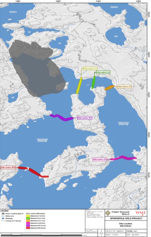
Source: Adapted from Springpole Gold project, Environmental Impact Statement, Figure 4.4-1.
Figure B-1: Dyke location alternatives - Text version
A map depicting the geographic locations of the dyke alternatives for the Springpole Gold Project. Alternatives E1, E2, and E3 are located southeast of the open pit within close proximity of one another while alternative E4 is located further southeast. Alternative W1 is located south of the open pit Lake and alternative W2 is located further south of the open pit and alternative W1.
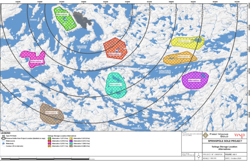
Source: Adapted from Springpole Gold Project, Environmental Impact Statement, Figure 4.6-1.
Figure B-2: Tailings storage location alternatives - Text version
A map depicting the geographic locations of the mine rock storage alternatives (Alternatives 1 and 2 only) and the tailings storage alternatives (Alternatives 1 through 8) for the Springpole Gold Project. Alternative 1 is located west of the open pit and adjacent to Birch Lake and Springpole Lake. Alternative 3 is located southwest of the open pit and Alternative 8 is located south of Alternative 3. Alternative 2 is located southeast of the open pit and alternative 7 is located south of Alternative 2. Alternatives 4, 5 and 6 are located further southeast of the open pit than Alternative 2.
Annex C: Environmental effects rating criteria
This annex sets out general definitions of the criteria used to describe the project's residual effects, as well as the definition of levels for extent, duration, frequency, reversibility, and timing applicable to all valued components (Table C-1), the definition of levels for magnitude specific to each valued component (Table C-2). Based on these criteria, IAAC considers whether the project is likely to cause significant residual environmental effects; in reaching its conclusions, IAAC takes into account the decision tree presented in Table C-3. In using this decision tree, IAAC considers whether the timing of the residual effect or the ecological and social context influence the other criteria, such as magnitude of reversibility.
General definitions of the criteria used to describe residual effects:
- Magnitude: The degree of change in a measurable parameter or variable relative to baseline conditions, defined for each valued component as low, moderate, high, or other qualifier deemed appropriate. Refer to Table C-2 for magnitude rating definitions specific to each valued component.
- Geographic Extent: The geographic or spatial boundaries within which the residual effect is expected to occur, defined for each valued component based on definitions of the project development area (PDA), local study area (LSA), and regional study area (RSA). Definitions for the spatial boundaries identified for each valued component are presented in Table C-1.
- Frequency: How often the residual effect would occur during a project phase or activity in a specified time period.
- Duration: The period of time over which the residual effect would occur, defined as short-term, medium-term, and long-term.
- Reversibility: Whether the residual effect on the valued component(s) can be returned to its previous condition or other target once the activity or component causing the disturbance ceases.
- Timing: Consideration of the periods of time during which a residual effect is expected to occur (e.g., species breeding season, Indigenous spiritual and cultural practices).
- Significance: The significance of the residual effect is determined by the combination of the levels assigned to each of the criteria above for each component and using thresholds of significance defined for each valued component.
- The ecological and social context within which potential environmental effects may occur should be taken into account when considering the key criteria above in relation to a particular valued component, as the context may help better characterize whether residual effects are significant. For example, information on the context is useful when it reveals a unique characteristic of the area (e.g., proximity to valuable heritage resources) or unique values or customs of a community that influence the perception of an environmental effect (including cultural factors).
|
Assessment criterion |
Low |
Moderate |
High |
|---|---|---|---|
|
Geographic Extent |
Project Development Area Effects that occur within the project development area, including a 250-metre buffer around the mine site, a 30-metre corridor for the mine access road, and a 40-metre corridor for the transmission line. The shared corridor for the transmission line and mine access road is 60 metres wide. |
Local Study Area Effects that occur within the local study area (as defined for each valued component). |
Regional Study Area Effects that occur within the regional study area (as defined for each valued component). |
|
Duration |
Short-term Effects that occur during the construction phase (over a period of less than 3 years) OR that occur within one generation or recovery cycle of the environmental component. |
Medium-term Effects that occur during the operations and decommissioning phases (over a period of 3 to 15 years) OR that extend to one or two generations or recovery cycles of the environmental component. |
Long-term Effects that occur during and after the abandonment phase (over a period of more than 15 years) OR that extend for more than two generations or recovery cycles of the environmental component. |
|
Frequency |
Once Occurs once during any phase of the project. |
Intermittent Occurs occasionally or at intermittent intervals during one or more phases of the project. |
Continuous Occurs continuously during one or more phases of the project. |
|
Reversibility |
Reversible The valued component will recover completely from the project's effects. |
Partially Reversible The valued component will partially recover from the project's effects. |
Irreversible The valued component will not recover from the project's effects. |
|
Timing |
Inconsequential Timing of the residual effects are not expected to affect sensitive activities. |
Moderate Timing of the residual effects may affect sensitive activities. |
Unfavourable Timing of the residual effects would affect sensitive activities. |
|
Valued Component |
Low |
Moderate |
High |
|---|---|---|---|
|
Fish and Fish Habitat |
Measurable effect on fish health or fish habitat in the receiving environment within the range of natural variability. |
Measurable effect on fish health or fish populations in the receiving environment but would not likely result in changes to the regional status of fish populations and health. |
Measurable effect on fish health or fish populations in the receiving environment which could result in changes to the regional status of fish populations and health. |
|
Migratory Birds |
Measurable effect to migratory birds or unique migratory bird habitats within the range of natural variability. |
Measurable effect to individual migratory birds or unique migratory bird habitats but would not likely change the status of regional populations or availability of unique habitats. |
Measurable effect on migratory birds or unique migratory bird habitats which could result in changes to the status of regional populations or availability of unique habitats. |
|
Indigenous Peoples: Health Conditions |
Health effects related to exposure would be negligible or low. Level of exposure does not approach health-based standards. |
Measurable health effects due to exposure. Level of exposure approaches health-based standards. |
Measurable health effects due to exposure. Level of exposure above health-based standards. |
|
Indigenous Peoples: Socio-economic Conditions |
Change in a current activity that would require little to no alteration in behaviour. |
Change in a current activity that would require some alteration in behaviour to carry out the activity. |
Change in a current activity that would mean the activity no longer can be carried out. |
|
Indigenous Peoples: Current Use of Lands and Resources for Traditional Purposes |
The effects would alter the conditions of traditional practices in a manner resulting in few changes to current use; OR The effects would involve few changes to behaviour, allowing current use of the practice to continue, in accordance with preferred ways or valued locations. |
The effects would alter the conditions of traditional practices without compromising current use; OR Some behaviours would be modified, but current use would not be compromised. |
The effects would alter the conditions of traditional practices in a manner resulting in changes that would compromise current use; OR Current use would no longer be possible in accordance with preferred ways or would be compromised in the only suitable, available, or most valued locations. |
|
Indigenous Peoples: Physical and Cultural Heritage and Sites of Significance |
The effect would slightly alter the characteristics of the unique nature of an element of the physical or cultural heritage and/or of a structure, site or thing of historical, archaeological, paleontological or architectural significance; OR Access to or use of an element of the physical or cultural heritage and/or of a structure, site or thing of importance would not be altered for users. |
The effect would alter some characteristics of the unique nature of an element of the physical or cultural heritage and/or of a structure, site or thing of historical, archaeological, paleontological or architectural significance, but would not compromise its integrity; OR Access to or use of an element of the physical or cultural heritage and/or of a structure, site or thing would be altered but would not be compromised for users. |
The effect would lead to the loss of characteristics of the unique nature of an element of the physical or cultural heritage or of a structure, site or thing of historical, archaeological, paleontological or architectural significance, such that its integrity would be compromised; OR The effect would prevent users from accessing or using an element of the physical or cultural heritage or a structure, site or thing of historical, archaeological, paleontological or architectural significance. |
|
Federal Decisions: Wetlands, Riparian Areas, and Wildlife |
Measurable effect on wetlands, riparian areas, and wildlife that depend on them in the receiving environment within the range of natural variability. |
Measurable effect on wetlands, riparian areas, and wildlife that depend on them in the receiving environment, but not likely to result in changes to the regional status of wildlife populations. |
Measurable effect on wetlands, riparian areas, and wildlife that depend on them in the receiving environment which could result in changes to the regional status of wetlands, riparian areas, and wildlife populations. |
|
Federal Decisions: Navigability, Recreational Fishing, and Bait Harvesting |
Change in current activity that would require little to no alteration in behaviour. |
Change in current activity that would require some alteration in behaviour to carry out the activity. |
Change in a current activity that would mean the activity no longer can be carried out. |
|
Federal Lands: Vegetation Communities |
Measurable effect on vegetation communities within the range of natural variability. |
Measurable effect on vegetation communities but would not likely result in changes to the regional status of vegetation populations and health. |
Measurable effect on vegetation communities which could result in changes to the regional status of vegetation populations and health. |
|
Federal Lands: Wildlife and Wildlife Habitat |
Measurable effect on wildlife and wildlife habitat within the range of natural variability. |
Measurable effect on wildlife and wildlife habitat but would not likely result in changes to the regional status of wildlife populations and health. |
Measurable effect on wildlife and wildlife habitat which could result in changes to the regional status of wildlife populations and health. |
|
Magnitude |
Geographic Extent |
Duration |
Frequency |
Reversibility |
Significance |
|---|---|---|---|---|---|
|
Low |
Any Extent |
Any Duration |
Any Level of Frequency |
Any Level of Reversibility |
Not Significant |
|
Moderate |
Project Development Area |
Short-term or medium-term |
Once or Intermittent |
Any Level of Reversibility |
Not Significant |
|
Continuous |
Fully or Partially Reversible |
Not Significant |
|||
|
Irreversible |
Not Significant |
||||
|
Long-term |
Any Level of Frequency |
Fully or Partially Reversible |
Not Significant |
||
|
Irreversible |
Significant |
||||
|
Local Study Area |
Short-term |
Once or Intermittent |
Any Level of Reversibility |
Not Significant |
|
|
Continuous |
Fully or Partially Reversible |
Not Significant |
|||
|
Irreversible |
Significant |
||||
|
Medium-term or Long-term |
Once |
Any Level of Reversibility |
Not Significant |
||
|
Intermittent or Continuous |
Fully or Partially Reversible |
Not Significant |
|||
|
Irreversible |
Significant |
||||
|
Regional Study Area |
Short-term |
Once or Intermittent |
Any Level of Reversibility |
Not Significant |
|
|
Continuous |
Any Level of Reversibility |
Significant |
|||
|
Medium-term |
Once |
Any Level of Reversibility |
Not Significant |
||
|
Intermittent or Continuous |
Any Level of Reversibility |
Significant |
|||
|
Long-term |
Any Level of Frequency |
Any Level of Reversibility |
Significant |
||
|
High |
Project Development Area |
Short-term or Medium-term |
Any Level of Frequency |
Any Level of Reversibility |
Not Significant |
|
Long-term |
Any Level of Frequency |
Fully or Partially Reversible |
Not Significant |
||
|
Irreversible |
Significant |
||||
|
Local Study Area |
Any Duration |
Any Level of Frequency |
Fully or Partially Reversible |
Not Significant |
|
|
Irreversible |
Significant |
||||
|
Regional Study Area |
Any Duration |
Any Level of Frequency |
Any Level of Reversibility |
Significant |